School nearby Helm's Skole
Denmark
School nearby Helm's Skole
Helm's Skole
Dahlsvej 8, Korsør Danmark
contacts phone
:
+45
Latitude:
55.3276197
, Longitude:
11.1436278
read more
nearest School
218 m
Musik og Rytmik
Skovvej 27, Korsør
School
read more
218 m
Music and Rhythm v / Toke Stryhn
Skovvej 27, Korsør
School
read more
250 m
Baggesenskolen
Birchnersgade 1, 4220 Korsør, Korsør
School
read more
279 m
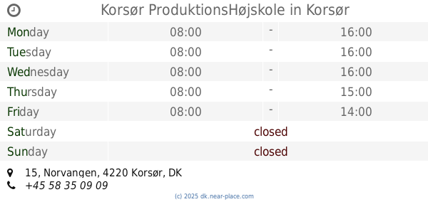
Korsør ProduktionsHøjskole
Norvangen 15, Korsør
School
read more
496 m
Børnehaven Mariehønen
Grevsensgade 6, Korsør
School
read more
1.035 km
Børnehaven Lilleskov
Lilleskovvej 3, Korsør
School
read more
1.237 km
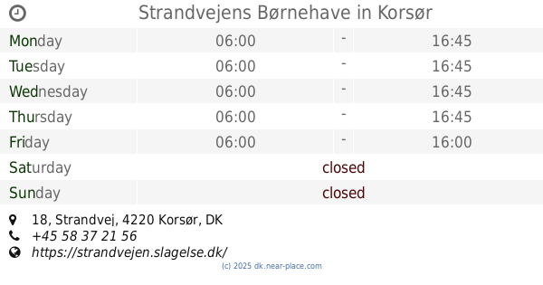
Strandvejens Børnehave
Strandvej 18, Korsør
School
read more
1.286 km
Studia.dk - Lær Italiensk med entusiasme
Suhrsvej 3 2 TV, Korsør
School
read more
1.484 km
Børnehuset Ved Noret
Nor Alleen 4, Korsør
School
read more
1.704 km
Sara budek
Mosevangen 16, Korsør
School
read more
1.962 km
Broskolen
Birkemosevej 11, Korsør
School
read more
2.76 km
Storebæltskolen
Storebælts Erhvervspark 1, Korsør
School
read more
4.241 km
Tårnborg Skole
Tjærebyvej 1, Korsør
School
read more
8.092 km
Boeslunde Skole
Borgbjergvej 13, Boeslunde
School
read more
13.412 km
Kies
Julius Andersens Vej 25, København SV
School
read more
14.071 km
Landsgrav Friskole
Bagervej 5, Slagelse
School
read more
14.697 km
Slagelse Gymnasium
Willemoesvej 2, Slagelse
School
read more
14.889 km
ZBC-Selandia
Bredahlsgade 1, Slagelse
School
read more
15.18 km
Rosenkilde Efterskole og STU-Kollegie
Anholtvej 3, Slagelse
School
read more
15.18 km
Rosenkilde School and STU Student
Anholtvej 3, Slagelse
School
read more
15.756 km
LOF Slagelse Korsør Skælskør
Gamle Torv 4A, Slagelse
School
read more
16.303 km
Børnehuset Nord
Kierulffsvej 2, Slagelse
School
read more
16.366 km
Kokke- & Tjenerskolen og Skolehjemmet, Selandia
Valbyvej 69 B, C, D, Slagelse
School
read more
16.376 km
Portnerboligen, Selandia
Valbyvej 69A, Slagelse
School
read more
16.622 km
Lindholm Dagskole ApS
Rosenkildevej 46, Slagelse
School
read more
📑
all categories
Accounting
Administrative area level 1
Administrative area level 2
Airport
Amusement park
Aquarium
Art gallery
Atm
Bakery
Bank
Bar
Beauty salon
Bicycle store
Book store
Bowling alley
Bus station
Cafe
Campground
Car dealer
Car rental
Car repair
Car wash
Casino
Cemetery
Church
City hall
Clothing store
Colloquial area
Convenience store
Country
Courthouse
Dentist
Department store
Doctor
Electrician
Electronics store
Embassy
Finance
Fire station
Florist
Food
Funeral home
Furniture store
Gas station
General contractor
Grocery or supermarket
Gym
Hair care
Hardware store
Health
Hindu Temple
Home goods store
Hospital
Insurance agency
Jewelry store
Laundry
Lawyer
Library
Light rail station
Liquor store
Local government office
Locality
Locksmith
Lodging
Meal delivery
Meal takeaway
Mosque
Movie rental
Movie theater
Moving company
Museum
Natural feature
Neighborhood
Night club
Painter
Park
Parking
Pet store
Pharmacy
Physiotherapist
Place of worship
Plumber
Point of interest
Police
Political
Post office
Premise
Real estate agency
Restaurant
Roofing contractor
Route
Rv park, camping
School
Shoe store
Shopping mall
Spa
Stadium
Storage
Store
Subpremise
Subway station
Supermarket
Synagogue
Taxi stand
Train station
Transit station
Travel agency
University
Veterinary care
Zoo
sublocality level 1
sublocality level 2
↑