School nearby Boeslunde Skole
Denmark
School nearby Boeslunde Skole
Boeslunde Skole
Borgbjergvej 13, Boeslunde Denmark
contacts phone
:
+45
Latitude:
55.298696
, Longitude:
11.260997
read more
nearest School
2.375 km
Lille Egede Friskole Selvej.inst.
Korsør Landevej 628, Boeslunde
School
read more
2.45 km
Fribørnehaven Ravnereden
Korsør Landevej 628, Boeslunde
School
read more
6.709 km
Børnehuset Ved Noret
Nor Alleen 4, Korsør
School
read more
7.096 km
Børnehaven Lilleskov
Lilleskovvej 3, Korsør
School
read more
7.961 km
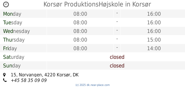
Korsør ProduktionsHøjskole
Norvangen 15, Korsør
School
read more
8.092 km
Helm's Skole
Dahlsvej 8, Korsør
School
read more
9.148 km
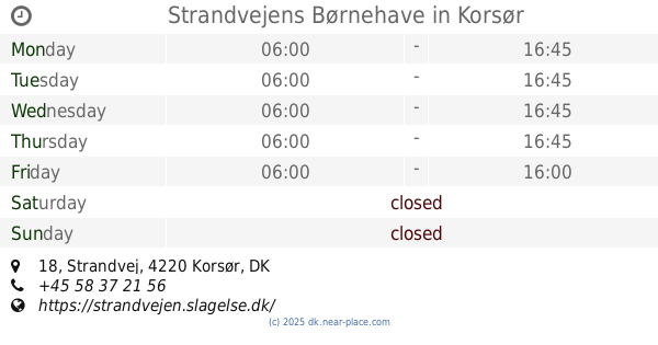
Strandvejens Børnehave
Strandvej 18, Korsør
School
read more
11.305 km
Kies
Julius Andersens Vej 25, København SV
School
read more
11.574 km
Landsgrav Friskole
Bagervej 5, Slagelse
School
read more
11.684 km
Børneinstitutionen Sydbyen
Fejøvej 1A, Slagelse
School
read more
12.061 km
Rosenkilde School and STU Student
Anholtvej 3, Slagelse
School
read more
12.061 km
Rosenkilde Efterskole og STU-Kollegie
Anholtvej 3, Slagelse
School
read more
12.079 km
Antvorskov Skole
Sejerøvej 1, Slagelse
School
read more
12.363 km
Slagelse Gymnasium
Willemoesvej 2, Slagelse
School
read more
12.618 km
ZBC-Selandia
Bredahlsgade 1, Slagelse
School
read more
13.021 km
LOF Slagelse Korsør Skælskør
Gamle Torv 4A, Slagelse
School
read more
13.021 km
FOF Syd- og Vestsjælland
1., Gamle Torv 4A, Slagelse
School
read more
13.104 km
Østre Skole
Skovsøgade 10, Slagelse
School
read more
13.248 km
Absalon
Ingemannsvej 17, Slagelse
School
read more
13.342 km
Frirumlab
Jernbanegade 10, Slagelse
School
read more
14.014 km
Lindholm Dagskole ApS
Rosenkildevej 46, Slagelse
School
read more
14.1 km
Børnehuset Nord
Kierulffsvej 2, Slagelse
School
read more
14.267 km
Portnerboligen, Selandia
Valbyvej 69A, Slagelse
School
read more
14.275 km
Kokke- & Tjenerskolen og Skolehjemmet, Selandia
Valbyvej 69 B, C, D, Slagelse
School
read more
14.925 km
Firkløveren
Skanderborgvej 9, Slagelse
School
read more
📑
all categories
Accounting
Administrative area level 1
Administrative area level 2
Airport
Amusement park
Aquarium
Art gallery
Atm
Bakery
Bank
Bar
Beauty salon
Bicycle store
Book store
Bowling alley
Bus station
Cafe
Campground
Car dealer
Car rental
Car repair
Car wash
Casino
Cemetery
Church
City hall
Clothing store
Colloquial area
Convenience store
Country
Courthouse
Dentist
Department store
Doctor
Electrician
Electronics store
Embassy
Finance
Fire station
Florist
Food
Funeral home
Furniture store
Gas station
General contractor
Grocery or supermarket
Gym
Hair care
Hardware store
Health
Hindu Temple
Home goods store
Hospital
Insurance agency
Jewelry store
Laundry
Lawyer
Library
Light rail station
Liquor store
Local government office
Locality
Locksmith
Lodging
Meal delivery
Meal takeaway
Mosque
Movie rental
Movie theater
Moving company
Museum
Natural feature
Neighborhood
Night club
Painter
Park
Parking
Pet store
Pharmacy
Physiotherapist
Place of worship
Plumber
Point of interest
Police
Political
Post office
Premise
Real estate agency
Restaurant
Roofing contractor
Route
Rv park, camping
School
Shoe store
Shopping mall
Spa
Stadium
Storage
Store
Subpremise
Subway station
Supermarket
Synagogue
Taxi stand
Train station
Transit station
Travel agency
University
Veterinary care
Zoo
sublocality level 1
sublocality level 2
↑