Supermarket nearby SuperBrugsen Glyngøre
Denmark
Supermarket nearby SuperBrugsen Glyngøre
SuperBrugsen Glyngøre
Bredgade 4, Roslev Danmark
contacts phone
:
+45
Latitude:
56.7618711
, Longitude:
8.8667184
read more
nearest Supermarket
2.272 km
Dagli'Brugsen
Faaruphusevej 1, Nykøbing Mors
Supermarket
read more
3.022 km
SPAR
Fruevej 37-41, Nykøbing Mors
Supermarket
read more
3.555 km
ALDI
Broen 2, Nykøbing Mors
Supermarket
read more
3.607 km
Netto Nykøbing mors
Vestergade 23, Nykøbing Mors
Supermarket
read more
3.639 km
Løvbjerg Supermarked A/S
Vestergade 15, Nykøbing Mors
Supermarket
read more
3.756 km
Fakta
Algade 5, Nykøbing Mors
Supermarket
read more
3.781 km
Min Købmand
Havnen 13, Nykøbing Mors
Supermarket
read more
3.848 km
LIDL
Grønnegade 12, Nykøbing Mors
Supermarket
read more
22.021 km
Fakta
Frugtparken 3, Skive
Supermarket
read more
23.002 km
REMA 1000
Holstebrovej 70, Skive
Supermarket
read more
23.066 km
Netto
Holstebrovej 91, Skive
Supermarket
read more
23.375 km
SPAR
Iversensvej 1, Thisted
Supermarket
read more
23.375 km
SPAR Thisted
Iversensvej 1, Thisted
Supermarket
read more
23.561 km
Rema 1000
Nørregade 40, Skive
Supermarket
read more
23.873 km
LIDL
Østerbakken 71, Thisted
Supermarket
read more
24.035 km
SuperBrugsen Thisted
Vestergade 15, Thisted
Supermarket
read more
24.075 km
Fakta
Kastet 39, Thisted
Supermarket
read more
24.173 km
Land og fritid Thisted
Tigervej 1, Thisted
Supermarket
read more
24.24 km
føtex Skive
Søndergade 19-21, Skive
Supermarket
read more
24.253 km
ALDI Thisted
Simons Bakke 70-74, Thisted
Supermarket
read more
24.32 km
Dagrofa S-Engros Thisted
Industrivej 8, Thisted
Supermarket
read more
25.264 km
REMA 1000
Brårupvej 58, Skive
Supermarket
read more
25.388 km
Fakta
Kirke Alle 92, Skive
Supermarket
read more
25.618 km
Superdøgneren
Dalgas Alle 36, Skive
Supermarket
read more
31.292 km
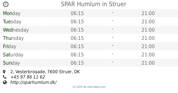
SPAR Humlum
Vesterbrogade 2, Struer
Supermarket
read more
📑
all categories
Accounting
Administrative area level 1
Administrative area level 2
Airport
Amusement park
Aquarium
Art gallery
Atm
Bakery
Bank
Bar
Beauty salon
Bicycle store
Book store
Bowling alley
Bus station
Cafe
Campground
Car dealer
Car rental
Car repair
Car wash
Casino
Cemetery
Church
City hall
Clothing store
Colloquial area
Convenience store
Country
Courthouse
Dentist
Department store
Doctor
Electrician
Electronics store
Embassy
Finance
Fire station
Florist
Food
Funeral home
Furniture store
Gas station
General contractor
Grocery or supermarket
Gym
Hair care
Hardware store
Health
Hindu Temple
Home goods store
Hospital
Insurance agency
Jewelry store
Laundry
Lawyer
Library
Light rail station
Liquor store
Local government office
Locality
Locksmith
Lodging
Meal delivery
Meal takeaway
Mosque
Movie rental
Movie theater
Moving company
Museum
Natural feature
Neighborhood
Night club
Painter
Park
Parking
Pet store
Pharmacy
Physiotherapist
Place of worship
Plumber
Point of interest
Police
Political
Post office
Premise
Real estate agency
Restaurant
Roofing contractor
Route
Rv park, camping
School
Shoe store
Shopping mall
Spa
Stadium
Storage
Store
Subpremise
Subway station
Supermarket
Synagogue
Taxi stand
Train station
Transit station
Travel agency
University
Veterinary care
Zoo
sublocality level 1
sublocality level 2
↑