Supermarket nearby Netto
Denmark
Supermarket nearby Netto
Netto
Roskildevej 294, Vipperød Dinamarca
contacts phone
:
+45
Latitude:
55.6701641
, Longitude:
11.7429509
read more
nearest Supermarket
422 m
Vipperød Og Omegns Brugsforening
Stationsvej 2, Vipperød
Supermarket
read more
438 m
Postkasse
Stationsvej 2, Vipperød
Supermarket
read more
438 m
Dagli'Brugsen Vipperød
Stationsvej 2-4, Vipperød
Supermarket
read more
3.091 km
REMA 1000
Roskildevej 201, Holbæk
Supermarket
read more
3.272 km
Dagrofa S-Engros Holbæk
Rørvangsvej 10, Holbæk
Supermarket
read more
4.387 km
Fakta
Tåstrup Møllevej 2, Holbæk
Supermarket
read more
4.389 km
Lidl
Tåstrup Møllevej 1, Holbæk
Supermarket
read more
4.483 km
REMA 1000
Halvmånen 61, Holbæk
Supermarket
read more
4.526 km
Netto
Spånnebæk 1, Holbæk
Supermarket
read more
4.568 km
Dansk Supermarked A/S
Gl.Ringstedvej 22, Holbæk
Supermarket
read more
4.568 km
Danish Supermarked A / S
Gl.Ringstedvej 22, Holbæk
Supermarket
read more
4.906 km
Dagli'Brugsen
Ladegårdsparken Vest 167, Holbæk
Supermarket
read more
4.906 km
Dagli'Brugsen Holbæk
Ladegårdsparken Vest 167, Holbæk
Supermarket
read more
5.086 km
ALDI Holbæk
Borgm N E Hansensvej 3, Holbæk
Supermarket
read more
5.155 km
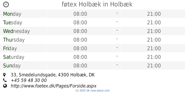
føtex Holbæk
Smedelundsgade 33, Holbæk
Supermarket
read more
5.155 km
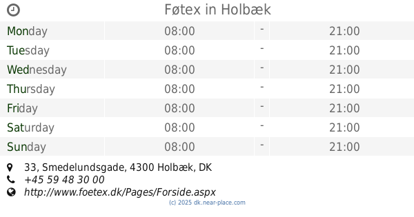
Føtex
Smedelundsgade 33, Holbæk
Supermarket
read more
5.224 km
MENY Holbæk
Smedelundsgade 24-26, Holbæk
Supermarket
read more
5.743 km
Netto
Søagervej 2, Holbæk
Supermarket
read more
6.576 km
SuperBrugsen
Vestergade 70, Tølløse
Supermarket
read more
6.576 km
SuperBrugsen Tølløse
Vestergade 70, Tølløse
Supermarket
read more
6.776 km
REMA 1000
Kalundborgvej 202, Holbæk
Supermarket
read more
7.817 km
Daglibrugsen Nr. Jernløse
Nørupvej 16, Regstrup
Supermarket
read more
8.568 km
Dagli'Brugsen Tuse
Butterupvej 2B, Holbæk
Supermarket
read more
14.125 km
Dagli'Brugsen Gislinge
Byvej 37, Gislinge
Supermarket
read more
18.803 km
DagliBrugsen Grevinge
Bytoften 2, Grevinge
Supermarket
read more
📑
all categories
Accounting
Administrative area level 1
Administrative area level 2
Airport
Amusement park
Aquarium
Art gallery
Atm
Bakery
Bank
Bar
Beauty salon
Bicycle store
Book store
Bowling alley
Bus station
Cafe
Campground
Car dealer
Car rental
Car repair
Car wash
Casino
Cemetery
Church
City hall
Clothing store
Colloquial area
Convenience store
Country
Courthouse
Dentist
Department store
Doctor
Electrician
Electronics store
Embassy
Finance
Fire station
Florist
Food
Funeral home
Furniture store
Gas station
General contractor
Grocery or supermarket
Gym
Hair care
Hardware store
Health
Hindu Temple
Home goods store
Hospital
Insurance agency
Jewelry store
Laundry
Lawyer
Library
Light rail station
Liquor store
Local government office
Locality
Locksmith
Lodging
Meal delivery
Meal takeaway
Mosque
Movie rental
Movie theater
Moving company
Museum
Natural feature
Neighborhood
Night club
Painter
Park
Parking
Pet store
Pharmacy
Physiotherapist
Place of worship
Plumber
Point of interest
Police
Political
Post office
Premise
Real estate agency
Restaurant
Roofing contractor
Route
Rv park, camping
School
Shoe store
Shopping mall
Spa
Stadium
Storage
Store
Subpremise
Subway station
Supermarket
Synagogue
Taxi stand
Train station
Transit station
Travel agency
University
Veterinary care
Zoo
sublocality level 1
sublocality level 2
↑