Supermarket nearby Netto
Denmark
Supermarket nearby Netto
Netto
50, Mølmarksvej, 5700, Svendborg, DK Dänemark
contacts phone
:
+45 87 78 78 11
website:
netto.dk
Latitude:
55.0682634
, Longitude:
10.6075734
larger map & directions
read more
nearest Supermarket
392 m
Købmand Spar
Mølmarksvej 101, Svendborg
Supermarket
read more
637 m
føtex Svendborg
Møllergade 92-96, Svendborg
Supermarket
read more
790 m
Fakta
Toldbodvej 15B, Svendborg
Supermarket
read more
820 m
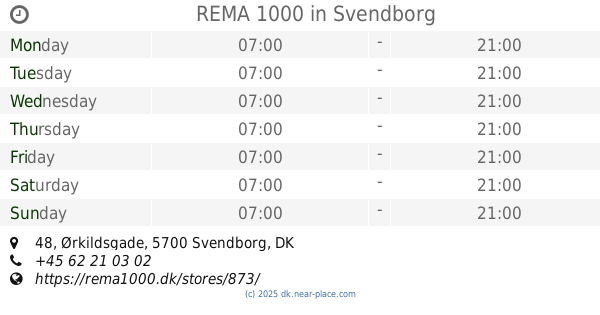
REMA 1000
52, Ørkildsgade 48, Svendborg
Supermarket
read more
958 m
ALDI Svendborg
Vestergade 115, Svendborg
Supermarket
read more
958 m
ALDI
Vestergade 115, Svendborg
Supermarket
read more
1.007 km
REMA 1000
75, Tvedvej 69, Svendborg
Supermarket
read more
1.137 km
Fakta
Vesterløkken 4, Svendborg
Supermarket
read more
1.15 km
Lidl
Mølmarksvej 185, Svendborg
Supermarket
read more
1.4 km
ALDI Svendborg
Nyborgvej 99, Svendborg
Supermarket
read more
1.4 km
ALDI
Nyborgvej 99, Svendborg
Supermarket
read more
1.4 km
ALDI Svendborg (Nyborgvej)
Nyborgvej 99, Svendborg
Supermarket
read more
1.491 km
Netto
Ørbækvej 11, Svendborg
Supermarket
read more
1.532 km
fakta Tved
Tvedvej 139A, Svendborg
Supermarket
read more
1.555 km
Fakta
Nyborgvej 134, Svendborg
Supermarket
read more
1.619 km
Netto
Ole Rømers Vej 65, Svendborg
Supermarket
read more
2.215 km
SPAR Tved
Tvedvej 201, Svendborg
Supermarket
read more
2.252 km
Dagrofa S-Engros Svendborg
Englandsvej 12, Svendborg
Supermarket
read more
2.252 km
Dagrofa S-Wholesale Svendborg
Englandsvej 12, Svendborg
Supermarket
read more
2.646 km
SPAR Svendborg, Wandallsvej
Wandallsvej 10, Svendborg
Supermarket
read more
3.081 km
REMA 1000
Bregningevej 58, Svendborg
Supermarket
read more
3.193 km
Dagli'Brugsen Vindeby
Solvej 1, Svendborg
Supermarket
read more
4.728 km
Dagli'Brugsen Rantzausminde
Rantzausmindevej 112, Svendborg
Supermarket
read more
4.913 km
SPAR Thurø
Bergmannsvej 112, Svendborg
Supermarket
read more
4.913 km
SPAR
Bergmannsvej 112, Svendborg
Supermarket
read more
📑
all categories
Accounting
Administrative area level 1
Administrative area level 2
Airport
Amusement park
Aquarium
Art gallery
Atm
Bakery
Bank
Bar
Beauty salon
Bicycle store
Book store
Bowling alley
Bus station
Cafe
Campground
Car dealer
Car rental
Car repair
Car wash
Casino
Cemetery
Church
City hall
Clothing store
Colloquial area
Convenience store
Country
Courthouse
Dentist
Department store
Doctor
Electrician
Electronics store
Embassy
Finance
Fire station
Florist
Food
Funeral home
Furniture store
Gas station
General contractor
Grocery or supermarket
Gym
Hair care
Hardware store
Health
Hindu Temple
Home goods store
Hospital
Insurance agency
Jewelry store
Laundry
Lawyer
Library
Light rail station
Liquor store
Local government office
Locality
Locksmith
Lodging
Meal delivery
Meal takeaway
Mosque
Movie rental
Movie theater
Moving company
Museum
Natural feature
Neighborhood
Night club
Painter
Park
Parking
Pet store
Pharmacy
Physiotherapist
Place of worship
Plumber
Point of interest
Police
Political
Post office
Premise
Real estate agency
Restaurant
Roofing contractor
Route
Rv park, camping
School
Shoe store
Shopping mall
Spa
Stadium
Storage
Store
Subpremise
Subway station
Supermarket
Synagogue
Taxi stand
Train station
Transit station
Travel agency
University
Veterinary care
Zoo
sublocality level 1
sublocality level 2
↑