Supermarket nearby Lidl
Denmark
Supermarket nearby Lidl
Lidl
3, Industrivej, 7600, Struer, DK Dinamarca
contacts phone
:
+45 80 70 27 02
website:
www.lidl.dk
Latitude:
56.486539
, Longitude:
8.5827956
larger map & directions
read more
nearest Supermarket
79 m
Netto
Industrivej 1B, Struer
Supermarket
read more
178 m
Løvbjerg Supermarked
Søndergårdsvej 2, Struer
Supermarket
read more
536 m
ALDI Struer
Holstebrovej 21-25, Struer
Supermarket
read more
536 m
ALDI
Holstebrovej 21-25, Struer
Supermarket
read more
593 m
MENY Struer
Ølbyvej 30, Struer
Supermarket
read more
708 m
Fakta
Bredgade 61, Struer
Supermarket
read more
746 m
REMA 1000
Vestergade 11, Struer
Supermarket
read more
6.191 km
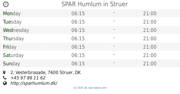
SPAR Humlum
Vesterbrogade 2, Struer
Supermarket
read more
12.221 km
Dagrofa S-Engros Holstebro
Niels Peter Thomsens Vej 9, Holstebro
Supermarket
read more
12.266 km
REMA 1000
Ellebækcentret, Beethovensvej 10, Holstebro
Supermarket
read more
12.266 km
Rema 1000 Ellebækcentret
Ellebækcentret, Beethovensvej 10, Holstebro
Supermarket
read more
12.287 km
MENY Holstebro
Beethovensvej 10, Holstebro
Supermarket
read more
12.287 km
Meny Ellebæk
Beethovensvej 10, Holstebro
Supermarket
read more
12.382 km
Bilka Holstebro
Nyholmvej 20, Holstebro
Supermarket
read more
12.503 km
Netto
Lavhedevej 54, Holstebro
Supermarket
read more
12.954 km
SPAR Holstebro, Døesvej
Døesvej 109, Holstebro
Supermarket
read more
13.642 km
REMA 1000
Døesvej 11, Holstebro
Supermarket
read more
13.644 km
ALDI Holstebro (Døesvej)
Døesvej 9, Holstebro
Supermarket
read more
13.644 km
ALDI Holstebro
Døesvej 9, Holstebro
Supermarket
read more
13.679 km
Netto
Banetoften 2, Holstebro
Supermarket
read more
13.793 km
Land & Fritid
Mads Bjerres Vej 2, Holstebro
Supermarket
read more
13.948 km
REMA 1000
Nørreport Centret, Holstebro
Supermarket
read more
14.435 km
Fakta
Enghaven 12, Holstebro
Supermarket
read more
14.436 km
Netto
Vestergade 7, Holstebro
Supermarket
read more
15.106 km
Dagli'Brugsen Mejrup
Viborgvej 111, Holstebro
Supermarket
read more
📑
all categories
Accounting
Administrative area level 1
Administrative area level 2
Airport
Amusement park
Aquarium
Art gallery
Atm
Bakery
Bank
Bar
Beauty salon
Bicycle store
Book store
Bowling alley
Bus station
Cafe
Campground
Car dealer
Car rental
Car repair
Car wash
Casino
Cemetery
Church
City hall
Clothing store
Colloquial area
Convenience store
Country
Courthouse
Dentist
Department store
Doctor
Electrician
Electronics store
Embassy
Finance
Fire station
Florist
Food
Funeral home
Furniture store
Gas station
General contractor
Grocery or supermarket
Gym
Hair care
Hardware store
Health
Hindu Temple
Home goods store
Hospital
Insurance agency
Jewelry store
Laundry
Lawyer
Library
Light rail station
Liquor store
Local government office
Locality
Locksmith
Lodging
Meal delivery
Meal takeaway
Mosque
Movie rental
Movie theater
Moving company
Museum
Natural feature
Neighborhood
Night club
Painter
Park
Parking
Pet store
Pharmacy
Physiotherapist
Place of worship
Plumber
Point of interest
Police
Political
Post office
Premise
Real estate agency
Restaurant
Roofing contractor
Route
Rv park, camping
School
Shoe store
Shopping mall
Spa
Stadium
Storage
Store
Subpremise
Subway station
Supermarket
Synagogue
Taxi stand
Train station
Transit station
Travel agency
University
Veterinary care
Zoo
sublocality level 1
sublocality level 2
↑