Supermarket nearby Føtex
Denmark
Supermarket nearby Føtex
Føtex
6, Stiholmsvej, 3460, Birkerød, DK Dinamarca
contacts phone
:
+45 45 17 90 00
website:
www.foetex.dk
Latitude:
55.8389923
, Longitude:
12.4305628
larger map & directions
read more
nearest Supermarket
83 m
Netto
Teglporten 25, Birkerød
Supermarket
read more
105 m
Irma
Hovedgaden 42, Birkerød
Supermarket
read more
649 m
ALDI Birkerød
Birkerød Kongevej 102, Birkerød
Supermarket
read more
868 m
REMA 1000
Bistrupvej 82, Birkerød
Supermarket
read more
1.099 km
SPAR Birkerød
Nørrevang 2A, Birkerød
Supermarket
read more
1.3 km
MENY Bistrup
Vasevej 119A, Birkerød
Supermarket
read more
1.312 km
Netto
Vasevej 111-115, Birkerød
Supermarket
read more
3.287 km
Stengårdens økologiske gårdbutik
Høveltevej 40, Birkerød
Supermarket
read more
3.974 km
REMA 1000
Kongevejen 15, Lillerød
Supermarket
read more
4.138 km
Lidl
Farum Bytorv 76, Farum
Supermarket
read more
4.396 km
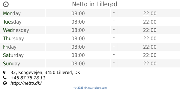
Netto
Kongevejen 32, Lillerød
Supermarket
read more
4.633 km
Lokalbrugsen Parcelvej
Parcelvej 71, Virum
Supermarket
read more
5.534 km
Fakta
Virum Torv 5, Virum
Supermarket
read more
5.576 km
MENY Virum
Geels Plads 20, Virum
Supermarket
read more
5.614 km
Netto
Akacietorvet 1, Farum
Supermarket
read more
5.649 km
ALDI Farum
Akacietorvet 2, Farum
Supermarket
read more
5.649 km
ALDI
Akacietorvet 2, Farum
Supermarket
read more
5.905 km
Netto
Allerød Stationsvej 11, Lillerød
Supermarket
read more
5.917 km
REMA 1000
Lilledal 18, Lillerød
Supermarket
read more
6.03 km
Ik-Refusion v/Irene Kratz
Gl Hovedgade 12, Hørsholm
Supermarket
read more
6.135 km
Netto
Hovedgaden 31, Hørsholm
Supermarket
read more
6.295 km
SuperBrugsen Hørsholm
Hørsholm Midtpunkt 37, Hørsholm
Supermarket
read more
6.295 km
SuperBrugsen
Hørsholm Midtpunkt 37, Hørsholm
Supermarket
read more
6.328 km
Irma
Hørsholm Midtpunkt 71, Hørsholm
Supermarket
read more
6.809 km
Netto
Lystoftevej 52
Supermarket
read more
📑
all categories
Accounting
Administrative area level 1
Administrative area level 2
Airport
Amusement park
Aquarium
Art gallery
Atm
Bakery
Bank
Bar
Beauty salon
Bicycle store
Book store
Bowling alley
Bus station
Cafe
Campground
Car dealer
Car rental
Car repair
Car wash
Casino
Cemetery
Church
City hall
Clothing store
Colloquial area
Convenience store
Country
Courthouse
Dentist
Department store
Doctor
Electrician
Electronics store
Embassy
Finance
Fire station
Florist
Food
Funeral home
Furniture store
Gas station
General contractor
Grocery or supermarket
Gym
Hair care
Hardware store
Health
Hindu Temple
Home goods store
Hospital
Insurance agency
Jewelry store
Laundry
Lawyer
Library
Light rail station
Liquor store
Local government office
Locality
Locksmith
Lodging
Meal delivery
Meal takeaway
Mosque
Movie rental
Movie theater
Moving company
Museum
Natural feature
Neighborhood
Night club
Painter
Park
Parking
Pet store
Pharmacy
Physiotherapist
Place of worship
Plumber
Point of interest
Police
Political
Post office
Premise
Real estate agency
Restaurant
Roofing contractor
Route
Rv park, camping
School
Shoe store
Shopping mall
Spa
Stadium
Storage
Store
Subpremise
Subway station
Supermarket
Synagogue
Taxi stand
Train station
Transit station
Travel agency
University
Veterinary care
Zoo
sublocality level 1
sublocality level 2
↑