Store nearby Top Print International
Denmark
Store nearby Top Print International
Top Print International
Ringbakken 11, Stenløse Danmark
contacts phone
:
+45
Latitude:
55.7841858
, Longitude:
12.2707658
read more
nearest Store
302 m
LejDetHer.dk - Afd. NORD
Lerbakken 4, Stenløse
Store
read more
302 m
LejDetHer.dk - GAD = Get And Drop Station - 3660 Stenløse
Lerbakken 4, Stenløse
Store
read more
811 m
Frugtfarmen
Toppevadvej 17, Stenløse
Store
read more
942 m
Laserpro.dk ApS
Bygaden 15, Stenløse
Store
read more
1.134 km
Dan Høns & Dyrefoder ApS
Farumvej 12, Stenløse
Store
read more
1.134 km
Dan Hens & Animal Feed ApS
Farumvej 12, Stenløse
Store
read more
1.412 km
Track The Stars ApS
Enghøjvej 17, Stenløse
Store
read more
1.482 km
Brudekjole udlejning
Knardrup Bygade 57, Stenløse
Store
read more
2.43 km
Gårdbutik: Møllehøj kartofler & grønt, v/Stig Sørensen
Brunhøjvej 6, Veksø
Store
read more
3.409 km
Campen Skilte v/John Campen
Bringevej 151, Måløv
Store
read more
3.431 km
ORIGIO
Knardrupvej, Måløv
Store
read more
3.57 km
Tengo Danmark I/S
Lejrvej 19, Værløse
Store
read more
4.006 km
Formula A/S
Måløv Værkstedsby 1, Måløv
Store
read more
4.276 km
Holmstrøm Værktøj/HSV Industri
Måløv Værkstedsby 88, Måløv
Store
read more
4.364 km
Kalkgaarden
Farumvej 137, Farum
Store
read more
4.467 km
Tryk 10
Frydensbergvej 31, Stenløse
Store
read more
4.469 km
Otkshop.dk
Frydensbergvej 22, Stenløse
Store
read more
4.551 km
Danish pharmaceutically Industri A / S
Dam Enge 4, Stenløse
Store
read more
4.651 km
HaveMekka.dk
Dam Enge 10, Stenløse
Store
read more
4.796 km
gufhuset
Måløv Hovedgade 69, Måløv
Store
read more
4.872 km
Storprint
Dam Holme 11, Stenløse
Store
read more
5.059 km
Røde Kors Butik Egedal
Damgårdsvej 15, Stenløse
Store
read more
5.202 km
Centerslagteren V/søren Jensen
Egedal Centret 28, Stenløse
Store
read more
5.233 km
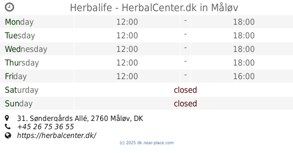
Herbalife - HerbalCenter.dk
Søndergårds Allé 31, Måløv
Store
read more
5.475 km
www.alun.dk
Hestetangsvej 58, Farum
Store
read more
📑
all categories
Accounting
Administrative area level 1
Administrative area level 2
Airport
Amusement park
Aquarium
Art gallery
Atm
Bakery
Bank
Bar
Beauty salon
Bicycle store
Book store
Bowling alley
Bus station
Cafe
Campground
Car dealer
Car rental
Car repair
Car wash
Casino
Cemetery
Church
City hall
Clothing store
Colloquial area
Convenience store
Country
Courthouse
Dentist
Department store
Doctor
Electrician
Electronics store
Embassy
Finance
Fire station
Florist
Food
Funeral home
Furniture store
Gas station
General contractor
Grocery or supermarket
Gym
Hair care
Hardware store
Health
Hindu Temple
Home goods store
Hospital
Insurance agency
Jewelry store
Laundry
Lawyer
Library
Light rail station
Liquor store
Local government office
Locality
Locksmith
Lodging
Meal delivery
Meal takeaway
Mosque
Movie rental
Movie theater
Moving company
Museum
Natural feature
Neighborhood
Night club
Painter
Park
Parking
Pet store
Pharmacy
Physiotherapist
Place of worship
Plumber
Point of interest
Police
Political
Post office
Premise
Real estate agency
Restaurant
Roofing contractor
Route
Rv park, camping
School
Shoe store
Shopping mall
Spa
Stadium
Storage
Store
Subpremise
Subway station
Supermarket
Synagogue
Taxi stand
Train station
Transit station
Travel agency
University
Veterinary care
Zoo
sublocality level 1
sublocality level 2
↑