Store nearby The Church Army Recycling
Denmark
Store nearby The Church Army Recycling
The Church Army Recycling
Kochsgade 120, 5000 Odense, Odense C Dania
contacts phone
:
+45
Latitude:
55.410747
, Longitude:
10.408416
read more
nearest Store
Kirkens Korshær Genbrug
Kochsgade 120, 5000 Odense, Odense C
Store
read more
519 m
SimpleConcept
Vinkældervej 1, Odense C
Store
read more
521 m
SimpleEntrance
Vinkældervej 1, Odense C
Store
read more
528 m
Påskeløkkens Købmand
Paaskeløkkevej 11, Odense C
Store
read more
823 m
Kiosk Etteren
Skibhusvej 169, Odense C
Store
read more
827 m
The mobile hearing clinic v / Danny Knudsen
Skibhusvej 171, Odense C
Store
read more
827 m
Den Mobile Høreklinik v/Danny Knudsen
Skibhusvej 171, Odense C
Store
read more
852 m
Hipstory
Annasholmsgade 27, Odense C
Store
read more
860 m
Sportsmentality
Skibhusvej 155, Odense C
Store
read more
866 m
KP Cykler
Odense
Store
read more
879 m
Rosticceria
Skibhusvej 140, Odense C
Store
read more
903 m
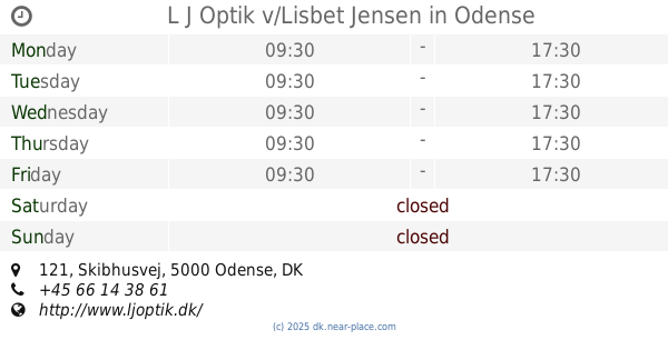
L J Optik v/Lisbet Jensen
Skibhusvej 121, Odense C
Store
read more
924 m
Odense Modeljernbanecenter
Kochsgade 35 B, Odense C
Store
read more
932 m
Anne's Smørrebrød
Skibhusvej 104, Odense C
Store
read more
966 m
Fabrikken
Østerbro 21, Odense C
Store
read more
975 m
XL-BYG Grønfeldt, Odense C. (for håndværkere)
Risingsvej 47, Odense C
Store
read more
980 m
Skibhusslagteren
Skibhusvej 92, Odense C
Store
read more
993 m
Genbrug-Xl v/ Ilse Juul Klausen
Østerbro 38, Odense C
Store
read more
1.001 km
fit 4 run
Skibhusvej 82, Odense C
Store
read more
1.001 km
Fit 4 Run v/ Brian Flemming
Skibhusvej 82, Odense C
Store
read more
1.008 km
Ting & Tøj
Skibhusvej 73, c/o Tina Hansen, Odense
Store
read more
1.031 km
Quick Order ApS
Kochsgade 31D, Odense C
Store
read more
1.05 km
Skibhus Optik
Skibhusvej 61, Odense C
Store
read more
1.053 km
Normann Optik
Skibhusvej 61, Odense C
Store
read more
1.219 km
Danske Stenhuggerier A/S - Odense
Østergade 50, Odense C
Store
read more
📑
all categories
Accounting
Administrative area level 1
Administrative area level 2
Airport
Amusement park
Aquarium
Art gallery
Atm
Bakery
Bank
Bar
Beauty salon
Bicycle store
Book store
Bowling alley
Bus station
Cafe
Campground
Car dealer
Car rental
Car repair
Car wash
Casino
Cemetery
Church
City hall
Clothing store
Colloquial area
Convenience store
Country
Courthouse
Dentist
Department store
Doctor
Electrician
Electronics store
Embassy
Finance
Fire station
Florist
Food
Funeral home
Furniture store
Gas station
General contractor
Grocery or supermarket
Gym
Hair care
Hardware store
Health
Hindu Temple
Home goods store
Hospital
Insurance agency
Jewelry store
Laundry
Lawyer
Library
Light rail station
Liquor store
Local government office
Locality
Locksmith
Lodging
Meal delivery
Meal takeaway
Mosque
Movie rental
Movie theater
Moving company
Museum
Natural feature
Neighborhood
Night club
Painter
Park
Parking
Pet store
Pharmacy
Physiotherapist
Place of worship
Plumber
Point of interest
Police
Political
Post office
Premise
Real estate agency
Restaurant
Roofing contractor
Route
Rv park, camping
School
Shoe store
Shopping mall
Spa
Stadium
Storage
Store
Subpremise
Subway station
Supermarket
Synagogue
Taxi stand
Train station
Transit station
Travel agency
University
Veterinary care
Zoo
sublocality level 1
sublocality level 2
↑