Store nearby Intersport
Denmark
Store nearby Intersport
Intersport
Cityringen 2, Taastrup Dania
contacts phone
:
+45
Latitude:
55.6435171
, Longitude:
12.27578
read more
nearest Store
16 m
Telia
Hveen Boulevard, Taastrup
Store
read more
31 m
Flying Tiger Copenhagen
Lejemål 1258, Hveen Boulevard, City 2, Taastrup
Store
read more
63 m
Panduro Hobby Taastrup
City 2, Hveen Blvd., Taastrup
Store
read more
104 m
BR
Cityringen 2, Taastrup
Store
read more
123 m
Normal City2
City2, Taastrup
Store
read more
123 m
Søstrene Grene - City 2
Cityringen 4, Taastrup
Store
read more
204 m
Thiele Briller & Kontaktlinser
Copenhagen Designer Outlet, Hveen Boulevard 1, Taastrup
Store
read more
214 m
Kings & Queens Outlet
6, Høje, Cityringen, Taastrup
Store
read more
231 m
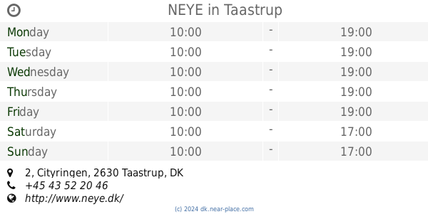
NEYE
City2, Cityringen 2, 328, Taastrup
Store
read more
516 m
AudioNova Hørecenter
Høje Taastrup Boulevard 76B, Taastrup
Store
read more
531 m
Heidemann graphic ApS
Høje Taastrup Boulevard 51, Taastrup
Store
read more
559 m
Tayyiber Food
Høje Taastrup Boulevard 68, Taastrup
Store
read more
575 m
REMA 1000
Høje, Tåstrup Boulevard 41, Taastrup
Store
read more
667 m
Banegårdens Frugt Og Grønt V/issam El-haj Hassan
Høje Taastrup Boulevard 42, Taastrup
Store
read more
747 m
Kontormøbler Brugte Køb og salg
Vandmestervej 20, Taastrup
Store
read more
763 m
7-Eleven Høje Taastrup Station
Banestrøget 1, Taastrup
Store
read more
839 m
Lef Thygesen Biler A/S
Vandmestervej 38, Taastrup
Store
read more
846 m
Auto Aid
Rugvænget 56, Taastrup
Store
read more
877 m
Stenby Tryk A/S
Husmandsvej 13 (indgang fra malervej 1), Taastrup
Store
read more
947 m
Zacho Food
Kuldyssen 12, Taastrup
Store
read more
973 m
Fitness Engros A/S
Snedkervej 4-6, Taastrup
Store
read more
983 m
Emborg Auto
Kuldyssen, Ved, Rugvænget 23, Taastrup
Store
read more
1.029 km
Johnny Juhl
Rugvænget 23, Taastrup
Store
read more
1.089 km
Taastrup Gravstensforretning & Stenhuggeri
Husmandsvej 2, Taastrup
Store
read more
1.26 km
L&C Diesel Power ApS
Bygaden 51B, Taastrup
Store
read more
📑
all categories
Accounting
Administrative area level 1
Administrative area level 2
Airport
Amusement park
Aquarium
Art gallery
Atm
Bakery
Bank
Bar
Beauty salon
Bicycle store
Book store
Bowling alley
Bus station
Cafe
Campground
Car dealer
Car rental
Car repair
Car wash
Casino
Cemetery
Church
City hall
Clothing store
Colloquial area
Convenience store
Country
Courthouse
Dentist
Department store
Doctor
Electrician
Electronics store
Embassy
Finance
Fire station
Florist
Food
Funeral home
Furniture store
Gas station
General contractor
Grocery or supermarket
Gym
Hair care
Hardware store
Health
Hindu Temple
Home goods store
Hospital
Insurance agency
Jewelry store
Laundry
Lawyer
Library
Light rail station
Liquor store
Local government office
Locality
Locksmith
Lodging
Meal delivery
Meal takeaway
Mosque
Movie rental
Movie theater
Moving company
Museum
Natural feature
Neighborhood
Night club
Painter
Park
Parking
Pet store
Pharmacy
Physiotherapist
Place of worship
Plumber
Point of interest
Police
Political
Post office
Premise
Real estate agency
Restaurant
Roofing contractor
Route
Rv park, camping
School
Shoe store
Shopping mall
Spa
Stadium
Storage
Store
Subpremise
Subway station
Supermarket
Synagogue
Taxi stand
Train station
Transit station
Travel agency
University
Veterinary care
Zoo
sublocality level 1
sublocality level 2
↑