Store nearby Dalbro Porcelænsbrænderi
Denmark
Store nearby Dalbro Porcelænsbrænderi
Dalbro Porcelænsbrænderi
Røde Mellemvej 28, København S Danmark
contacts phone
:
+45
Latitude:
55.6509962
, Longitude:
12.5924462
read more
nearest Store
412 m
Best Forever
Urmagerstien 4, København S
Store
read more
596 m
Accessories.DK
Hf. Sundbyvester, København S
Store
read more
691 m
Damperen
kld 58 Peder Lykkes Vej København S, København
Store
read more
706 m
sabaru forhandler
Englandsvej 51, København S
Store
read more
803 m
Koncerthusets Kundecenter
Ørestads Boulevard 13, København S
Store
read more
834 m
Kiosk 119
Røde Mellemvej 119, København S
Store
read more
1.031 km
ABC Modeljernbane
Sundholmsvej 56, København S
Store
read more
1.061 km
Bandagist Jan Nielsen A / S
Sundholmsvej 73, København S
Store
read more
1.061 km
Bandagist Jan Nielsen A/S
Sundholmsvej 73, København S
Store
read more
1.152 km
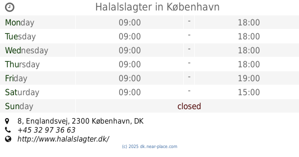
Halalslagter
Englandsvej 8, København S
Store
read more
1.229 km
Design and Print
Englandsvej 1, København S
Store
read more
1.229 km
Design og Tryk
Englandsvej 1, København S
Store
read more
1.231 km
Merco Print A/S
Englandsvej 1, København S
Store
read more
1.231 km
Regnbue Slik
st tv s, Amagerbrogade 128, København S
Store
read more
1.237 km
Leanbodies
Amagerbrogade 122, København S
Store
read more
1.259 km
Flying Tiger Copenhagen
Amagerbrogade 117, København S
Store
read more
1.263 km
Slagterbutik Amager ApS
Amagerbrogade 102, København S
Store
read more
1.264 km
Replenish
Øresundsvej 1, tv, København S
Store
read more
1.264 km
Replenish
Øresundsvej 1, København S
Store
read more
1.28 km
Bambi Slik
Lyongade 2, København S
Store
read more
1.28 km
Bambi Slik
Lyongade 2, København
Store
read more
1.294 km
Mondila market
Amagerbrogade 89, København S
Store
read more
1.302 km
Down Under Tattoo
Amagerbrogade 87, København S
Store
read more
1.302 km
Red Cross Op Shop
Amagerbrogade 87, København S
Store
read more
1.302 km
Røde Kors Butik - København S
Amagerbrogade 87, København S
Store
read more
📑
all categories
Accounting
Administrative area level 1
Administrative area level 2
Airport
Amusement park
Aquarium
Art gallery
Atm
Bakery
Bank
Bar
Beauty salon
Bicycle store
Book store
Bowling alley
Bus station
Cafe
Campground
Car dealer
Car rental
Car repair
Car wash
Casino
Cemetery
Church
City hall
Clothing store
Colloquial area
Convenience store
Country
Courthouse
Dentist
Department store
Doctor
Electrician
Electronics store
Embassy
Finance
Fire station
Florist
Food
Funeral home
Furniture store
Gas station
General contractor
Grocery or supermarket
Gym
Hair care
Hardware store
Health
Hindu Temple
Home goods store
Hospital
Insurance agency
Jewelry store
Laundry
Lawyer
Library
Light rail station
Liquor store
Local government office
Locality
Locksmith
Lodging
Meal delivery
Meal takeaway
Mosque
Movie rental
Movie theater
Moving company
Museum
Natural feature
Neighborhood
Night club
Painter
Park
Parking
Pet store
Pharmacy
Physiotherapist
Place of worship
Plumber
Point of interest
Police
Political
Post office
Premise
Real estate agency
Restaurant
Roofing contractor
Route
Rv park, camping
School
Shoe store
Shopping mall
Spa
Stadium
Storage
Store
Subpremise
Subway station
Supermarket
Synagogue
Taxi stand
Train station
Transit station
Travel agency
University
Veterinary care
Zoo
sublocality level 1
sublocality level 2
↑