Restaurant nearby WokAmok Køge
Denmark
Restaurant nearby WokAmok Køge
WokAmok Køge
Københavnsvej 116A, Køge Dinamarca
contacts phone
:
+45
Latitude:
55.4840712
, Longitude:
12.1877478
read more
nearest Restaurant
219 m
Sandwich 4600 (Krohns Køkken Aps)
Gammel Lyngvej 2, Køge
Restaurant
read more
257 m
Lyngen´s Pizza & Grill v/Sulaiman Nawabi
Københavnsvej 138, Køge
Restaurant
read more
257 m
Lyngens Pizza Grill
Københavnsvej 138, Køge
Restaurant
read more
962 m
Masa Køge
Ølbycenter 10, Køge
Restaurant
read more
975 m
Little Italy Restaurant
Ølbycenter 10, Køge
Restaurant
read more
975 m
La Piccola Italia
Ølbycenter 10, Køge
Restaurant
read more
1.183 km
Frokosthytten v/ Niels Knudsen
Tangmosevej 104, Køge
Restaurant
read more
1.522 km
Stacy's Diner
Bådehavnen 1, Køge
Restaurant
read more
1.597 km
Fru Klitgaard
Bådehavnen 8, Køge
Restaurant
read more
1.6 km
Gastronomia Italiana
Københavnsvej 68, Køge
Restaurant
read more
1.6 km
Gastronomia Italiana Køge
Københavnsvej 68, Køge
Restaurant
read more
1.612 km
Restaurant Arken
Bådehavnen 21, Køge
Restaurant
read more
1.651 km
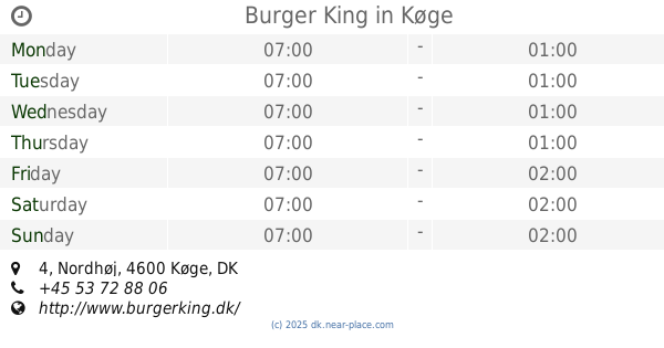
Burger King
Nordhøj 4, Køge
Restaurant
read more
1.954 km
7 Møllens Grill Køge
Nørre Boulevard 116, Køge
Restaurant
read more
2.115 km
Kinesisk Grill
Østre Sandmarksvej 14, Køge
Restaurant
read more
2.473 km
King of French Chicken v/Eyup Turan
Nørre Boulevard 55, Køge
Restaurant
read more
2.798 km
Shawarma Hus
Nørregade 33, Køge
Restaurant
read more
2.927 km
Xpress Kebab
Stationspladsen 3, Køge
Restaurant
read more
2.927 km
Xpress Kebab I/S
Stationspladsen 3, Køge
Restaurant
read more
2.95 km
Sct. Gertrud Køge ApS
Vestergade 34, Køge
Restaurant
read more
2.953 km
Café Liyana
Nørregade 9, Køge
Restaurant
read more
2.969 km
Odd Fellowgaarden
Jernbanegade 10, Køge
Restaurant
read more
2.984 km
Restaurant Zhou
Vestergade 20, Køge
Restaurant
read more
2.986 km
Restaurant Azuma
Vestergade 30, Køge
Restaurant
read more
3.03 km
Pappa's Juice & Sandwich
Vestergade 18, Køge
Restaurant
read more
📑
all categories
Accounting
Administrative area level 1
Administrative area level 2
Airport
Amusement park
Aquarium
Art gallery
Atm
Bakery
Bank
Bar
Beauty salon
Bicycle store
Book store
Bowling alley
Bus station
Cafe
Campground
Car dealer
Car rental
Car repair
Car wash
Casino
Cemetery
Church
City hall
Clothing store
Colloquial area
Convenience store
Country
Courthouse
Dentist
Department store
Doctor
Electrician
Electronics store
Embassy
Finance
Fire station
Florist
Food
Funeral home
Furniture store
Gas station
General contractor
Grocery or supermarket
Gym
Hair care
Hardware store
Health
Hindu Temple
Home goods store
Hospital
Insurance agency
Jewelry store
Laundry
Lawyer
Library
Light rail station
Liquor store
Local government office
Locality
Locksmith
Lodging
Meal delivery
Meal takeaway
Mosque
Movie rental
Movie theater
Moving company
Museum
Natural feature
Neighborhood
Night club
Painter
Park
Parking
Pet store
Pharmacy
Physiotherapist
Place of worship
Plumber
Point of interest
Police
Political
Post office
Premise
Real estate agency
Restaurant
Roofing contractor
Route
Rv park, camping
School
Shoe store
Shopping mall
Spa
Stadium
Storage
Store
Subpremise
Subway station
Supermarket
Synagogue
Taxi stand
Train station
Transit station
Travel agency
University
Veterinary care
Zoo
sublocality level 1
sublocality level 2
↑