Restaurant nearby Skyttehuset
Denmark
Restaurant nearby Skyttehuset
Skyttehuset
Tirsbæk Strandvej 2, Vejle Denmark
contacts phone
:
+45
Latitude:
55.7086636
, Longitude:
9.566265
read more
nearest Restaurant
672 m
Restaurant Remouladen
Stævnen 55, Vejle
Restaurant
read more
1.168 km
Mad & Brød
Valløesgade 14, Vejle
Restaurant
read more
1.337 km
Merlot
Skyttehusgade 42, Vejle
Restaurant
read more
1.5 km
Highway 51 Diner Vejle
Toldbodvej 13B, Vejle
Restaurant
read more
1.544 km
Burger King
Horsensvej 121, Vejle
Restaurant
read more
1.784 km
Restaurant Sømærket
Havnegade 9, Vejle
Restaurant
read more
1.861 km
Mohira
Dæmningen 42C, Vejle
Restaurant
read more
1.861 km
Restaurant Toscana v/Araz Tofek
Banegårdspladsen 1, Vejle
Restaurant
read more
1.866 km
Industriens Gadekøkken
Dæmningen 42E, Vejle
Restaurant
read more
1.868 km
Indisk
Dæmningen 42E, Vejle
Restaurant
read more
1.869 km
MOW asiatisk fusionskøkken
Dæmningen 42E, Vejle
Restaurant
read more
1.89 km
Tortilla Flats Vejle ApS
Dæmningen 44, Vejle
Restaurant
read more
1.892 km
Bone's Vejle
Nørretorv 9, Vejle
Restaurant
read more
1.907 km
Restaurant Zhou
Dæmningen 37, Vejle
Restaurant
read more
1.91 km
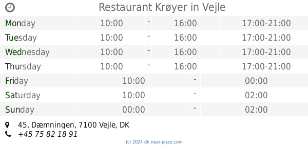
Restaurant Krøyer
Dæmningen 45, Vejle
Restaurant
read more
1.912 km
Indian Hut
Vestergade 34, Vejle
Restaurant
read more
1.913 km
Casa Argentina
Vestergade 11D, Vejle
Restaurant
read more
1.925 km
Istanbul Pizza
Nørregade 28, Vejle
Restaurant
read more
1.935 km
Delicious - Sandwich & Juice Vejle
Vestergade 45D, Vejle
Restaurant
read more
1.953 km
Mad Rick
Nørregade 55, Vejle
Restaurant
read more
1.957 km
Åbner 16 August
Nørregade 61, Vejle
Restaurant
read more
1.963 km
Carl's Jr
Solkilde Alle 2, Vejle
Restaurant
read more
1.971 km
Ristorante Daccapo
Tønnesgade 4, Vejle
Restaurant
read more
1.993 km
Moldevej markedsplads
Moldevej 85, Vejle
Restaurant
read more
2.027 km
Nr 41 v/Kirsten Prüsse
Staldgaardsgade 41, Vejle
Restaurant
read more
📑
all categories
Accounting
Administrative area level 1
Administrative area level 2
Airport
Amusement park
Aquarium
Art gallery
Atm
Bakery
Bank
Bar
Beauty salon
Bicycle store
Book store
Bowling alley
Bus station
Cafe
Campground
Car dealer
Car rental
Car repair
Car wash
Casino
Cemetery
Church
City hall
Clothing store
Colloquial area
Convenience store
Country
Courthouse
Dentist
Department store
Doctor
Electrician
Electronics store
Embassy
Finance
Fire station
Florist
Food
Funeral home
Furniture store
Gas station
General contractor
Grocery or supermarket
Gym
Hair care
Hardware store
Health
Hindu Temple
Home goods store
Hospital
Insurance agency
Jewelry store
Laundry
Lawyer
Library
Light rail station
Liquor store
Local government office
Locality
Locksmith
Lodging
Meal delivery
Meal takeaway
Mosque
Movie rental
Movie theater
Moving company
Museum
Natural feature
Neighborhood
Night club
Painter
Park
Parking
Pet store
Pharmacy
Physiotherapist
Place of worship
Plumber
Point of interest
Police
Political
Post office
Premise
Real estate agency
Restaurant
Roofing contractor
Route
Rv park, camping
School
Shoe store
Shopping mall
Spa
Stadium
Storage
Store
Subpremise
Subway station
Supermarket
Synagogue
Taxi stand
Train station
Transit station
Travel agency
University
Veterinary care
Zoo
sublocality level 1
sublocality level 2
↑