Parking nearby Enghavens parkeringsplads
Denmark
Parking nearby Enghavens parkeringsplads
Enghavens parkeringsplads
7500 Holstebro, Dänemark
contacts phone
:
+45
Latitude:
56.3589222
, Longitude:
8.6195067
larger map & directions
read more
nearest Parking
176 m
Faerch Torvets parking
Færch Torv, Holstebro
Parking
read more
176 m
Færch Torvets parkeringsplads
Færch Torv, Holstebro
Parking
read more
283 m
Q-Park
Bisgårdgade 11, Holstebro
Parking
read more
290 m
Parkering
Holstebro
Parking
read more
292 m
Free Parking Lot
Nellikestræde 3, Holstebro
Parking
read more
292 m
Parkeringsanlæg med gratis parkering
Nellikestræde 3, Holstebro
Parking
read more
306 m
Parkeringsplads Ved Sct. Jørgen Bakke
Sct Jørgens Gade 17, Holstebro
Parking
read more
306 m
Parking by Sct. Jørgen Bakke
Sct Jørgens Gade 17, Holstebro
Parking
read more
316 m
Parkeringsplads
Holstebro
Parking
read more
325 m
Nørreportcenterets parkeringsanlæg
Holstebro
Parking
read more
357 m
P-huset Skolegade
Skolegade 26, Holstebro
Parking
read more
376 m
Parkeringshus Skolegade
Skoleparken 24, Holstebro
Parking
read more
495 m
Nørreport
Stationsvej 2, Herning
Parking
read more
499 m
Parkering
Schaumburgvej 10, Holstebro
Parking
read more
532 m
Parkeringsplads ved Regionshospitalet Holstebro
Holstebro
Parking
read more
532 m
Car park at the Regional Hospital Holstebro
Holstebro
Parking
read more
808 m
Parking by Holstebro Train Station
Stationsvej 19, Holstebro
Parking
read more
808 m
Parkeringsplads ved Holstebro Togstation
Stationsvej 19, Holstebro
Parking
read more
813 m
Holstebro Station
Stationsvej 15, Herning
Parking
read more
1.369 km
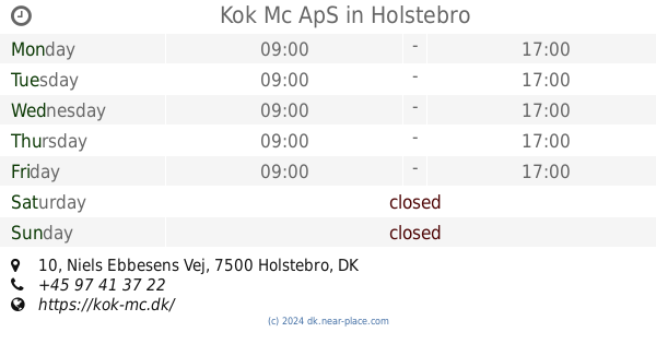
Kok Mc ApS
Niels Ebbesens Vej 10, Holstebro
Parking
read more
1.369 km
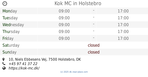
Kok MC
Niels Ebbesens Vej 10, Holstebro
Parking
read more
1.371 km
Parking spot By Lyksborgvej
Holstebro
Parking
read more
1.371 km
Parkingsplads Ved Lyksborgvej
Holstebro
Parking
read more
1.593 km
Parkeringsplads ved Gråkjær Arena
Hostrupsvej 23, Holstebro
Parking
read more
1.78 km
Fabersvej
Fabersvej, Holstebro
Parking
read more
📑
all categories
Accounting
Administrative area level 1
Administrative area level 2
Airport
Amusement park
Aquarium
Art gallery
Atm
Bakery
Bank
Bar
Beauty salon
Bicycle store
Book store
Bowling alley
Bus station
Cafe
Campground
Car dealer
Car rental
Car repair
Car wash
Casino
Cemetery
Church
City hall
Clothing store
Colloquial area
Convenience store
Country
Courthouse
Dentist
Department store
Doctor
Electrician
Electronics store
Embassy
Finance
Fire station
Florist
Food
Funeral home
Furniture store
Gas station
General contractor
Grocery or supermarket
Gym
Hair care
Hardware store
Health
Hindu Temple
Home goods store
Hospital
Insurance agency
Jewelry store
Laundry
Lawyer
Library
Light rail station
Liquor store
Local government office
Locality
Locksmith
Lodging
Meal delivery
Meal takeaway
Mosque
Movie rental
Movie theater
Moving company
Museum
Natural feature
Neighborhood
Night club
Painter
Park
Parking
Pet store
Pharmacy
Physiotherapist
Place of worship
Plumber
Point of interest
Police
Political
Post office
Premise
Real estate agency
Restaurant
Roofing contractor
Route
Rv park, camping
School
Shoe store
Shopping mall
Spa
Stadium
Storage
Store
Subpremise
Subway station
Supermarket
Synagogue
Taxi stand
Train station
Transit station
Travel agency
University
Veterinary care
Zoo
sublocality level 1
sublocality level 2
↑