Park nearby Ogrody Królewskie Rosenborg
Denmark
Park nearby Ogrody Królewskie Rosenborg
Ogrody Królewskie Rosenborg
Gothersgade, København K Danmark
contacts phone
:
+45
Latitude:
55.6844371
, Longitude:
12.5790245
read more
nearest Park
99 m
Drengen med svanen
København
Park
read more
99 m
The boy with the swan
København
Park
read more
108 m
The King's Garden
Øster Voldgade 4A, København
Park
read more
193 m
Rosenhaven
Øster Voldgade 4A, København K
Park
read more
301 m
Vand og Landskab v/Maja Møller Nikolajew
Møntergade 14, København K
Park
read more
368 m
Botanisk Have
Gothersgade 128, København
Park
read more
368 m
Botanical Garden
Gothersgade 128, København
Park
read more
394 m
Parkering
Borgergade 16, København K
Park
read more
458 m
Botanical Garden
Copenhagen
Park
read more
506 m
Klatretræ
Øster Voldgade 9, København K
Park
read more
507 m
Botanisk Have
Øster Farimagsgade 2C, København K
Park
read more
516 m
Christiansen / Ib E
Kongens Nytorv 24, København K
Park
read more
592 m
Sankt Pauls Kirke Hundegård
Sankt Pauls Plads 2, København K
Park
read more
610 m
Østre Anlæg park
Stockholmsgade 20, København Ø
Park
read more
615 m
Kongens Nytorv
Kongens Nytorv, København K
Park
read more
615 m
King's New Square
Kongens Nytorv, København K
Park
read more
624 m
Amagertorv
Amagertorv 1F, København K
Park
read more
624 m
Storkespringvandet
Amagertorv 6, København K
Park
read more
822 m
Caritasbrønden
Vestergade, København
Park
read more
847 m
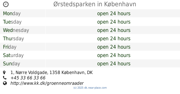
Ørstedsparken
Nørre Voldgade 1, København K
Park
read more
847 m
Ørsteds Park
Nørre Voldgade 1, København K
Park
read more
1.091 km
Regnbuepladsen
Regnbuepladsen 5, København V
Park
read more
1.133 km
City Hall Square
Copenhagen
Park
read more
1.133 km
Rådhuspladsen
København
Park
read more
1.178 km
Fredens Park
København
Park
read more
📑
all categories
Accounting
Administrative area level 1
Administrative area level 2
Airport
Amusement park
Aquarium
Art gallery
Atm
Bakery
Bank
Bar
Beauty salon
Bicycle store
Book store
Bowling alley
Bus station
Cafe
Campground
Car dealer
Car rental
Car repair
Car wash
Casino
Cemetery
Church
City hall
Clothing store
Colloquial area
Convenience store
Country
Courthouse
Dentist
Department store
Doctor
Electrician
Electronics store
Embassy
Finance
Fire station
Florist
Food
Funeral home
Furniture store
Gas station
General contractor
Grocery or supermarket
Gym
Hair care
Hardware store
Health
Hindu Temple
Home goods store
Hospital
Insurance agency
Jewelry store
Laundry
Lawyer
Library
Light rail station
Liquor store
Local government office
Locality
Locksmith
Lodging
Meal delivery
Meal takeaway
Mosque
Movie rental
Movie theater
Moving company
Museum
Natural feature
Neighborhood
Night club
Painter
Park
Parking
Pet store
Pharmacy
Physiotherapist
Place of worship
Plumber
Point of interest
Police
Political
Post office
Premise
Real estate agency
Restaurant
Roofing contractor
Route
Rv park, camping
School
Shoe store
Shopping mall
Spa
Stadium
Storage
Store
Subpremise
Subway station
Supermarket
Synagogue
Taxi stand
Train station
Transit station
Travel agency
University
Veterinary care
Zoo
sublocality level 1
sublocality level 2
↑