Night club nearby Cafe HOE
Denmark
Night club nearby Cafe HOE
Cafe HOE
3400, Slotsgade 47, Hillerød Dania
contacts phone
:
+45
Latitude:
55.9318263
, Longitude:
12.2988213
read more
nearest Night club
404 m
Downtown
Torvet 5A, Hillerød
Night club
read more
1.167 km
Caro-baby
Carlsbergvej 40, Hillerød
Night club
read more
11.018 km
cobra mc denmark
Nordkranvej 2, Lynge
Night club
read more
13.255 km
AL-Bank Lounge
Farum
Night club
read more
14.057 km
Billen Farum
Stavnsholtvej 5, Farum
Night club
read more
17.421 km
BallonService
Øverødvej 88, Holte
Night club
read more
19.418 km
Poptøsens Prinsessepalads
Rugvænget 2D, Stenløse
Night club
read more
19.62 km
Gorm klubben
Værløse
Night club
read more
21.953 km
Gladsaxe Jazzklub
Ulvebjerg 25, Bagsværd
Night club
read more
22.277 km
Rustik
Svingelport 1, Helsingør
Night club
read more
22.34 km
Gospelkor
Christian X's Alle 91, Kongens Lyngby
Night club
read more
22.598 km
Leos fylleparadis
Bjergegade 1, Helsingør
Night club
read more
23.352 km
K-one Studio
Sømoseparken 80, Ballerup
Night club
read more
24.474 km
Vangede Bygade 77
Ved Bommen 45, Gentofte
Night club
read more
24.574 km
Cubansk Salsadans
Telefonvej 8, Søborg
Night club
read more
24.853 km
Den Gule Stjerne
Gammel Køge Landevej, 650
Night club
read more
24.864 km
Ramp 32
A St, Mørkhøj Bygade 32, Søborg
Night club
read more
26.267 km
Underground Rock Centre
Dyssegård
Night club
read more
27.183 km
Yahyah
Korsager Allé 32, København
Night club
read more
27.412 km
The Tivoli - Bar, Mat & Live
Köpenhamnskajen 1, Helsingborg
Night club
read more
27.729 km
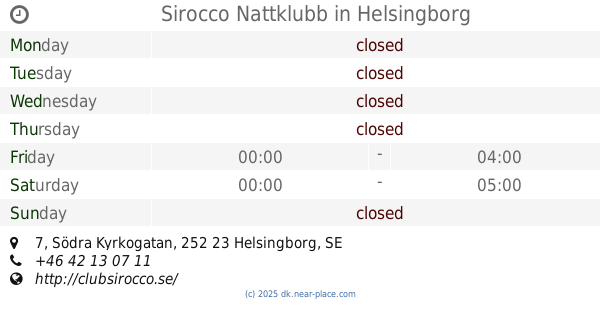
Sirocco Nattklubb
Södra Kyrkogatan 7, Helsingborg
Night club
read more
28.139 km
Utterslev Jazzcafé
Skoleholdervej 20, København NV
Night club
read more
28.48 km
Feddy Kouchstak
Copenhagen
Night club
read more
28.788 km
Meet - Restaurant / Bar / Lounge
Tuborg Havnevej 4, Hellerup
Night club
read more
30.045 km
Lauras lejlighed
Manøgade 3, København
Night club
read more
📑
all categories
Accounting
Administrative area level 1
Administrative area level 2
Airport
Amusement park
Aquarium
Art gallery
Atm
Bakery
Bank
Bar
Beauty salon
Bicycle store
Book store
Bowling alley
Bus station
Cafe
Campground
Car dealer
Car rental
Car repair
Car wash
Casino
Cemetery
Church
City hall
Clothing store
Colloquial area
Convenience store
Country
Courthouse
Dentist
Department store
Doctor
Electrician
Electronics store
Embassy
Finance
Fire station
Florist
Food
Funeral home
Furniture store
Gas station
General contractor
Grocery or supermarket
Gym
Hair care
Hardware store
Health
Hindu Temple
Home goods store
Hospital
Insurance agency
Jewelry store
Laundry
Lawyer
Library
Light rail station
Liquor store
Local government office
Locality
Locksmith
Lodging
Meal delivery
Meal takeaway
Mosque
Movie rental
Movie theater
Moving company
Museum
Natural feature
Neighborhood
Night club
Painter
Park
Parking
Pet store
Pharmacy
Physiotherapist
Place of worship
Plumber
Point of interest
Police
Political
Post office
Premise
Real estate agency
Restaurant
Roofing contractor
Route
Rv park, camping
School
Shoe store
Shopping mall
Spa
Stadium
Storage
Store
Subpremise
Subway station
Supermarket
Synagogue
Taxi stand
Train station
Transit station
Travel agency
University
Veterinary care
Zoo
sublocality level 1
sublocality level 2
↑