Lodging nearby Rønnede Kro
Denmark
Lodging nearby Rønnede Kro
Rønnede Kro
Vordingborgvej 530, Rønnede Danmark
contacts phone
:
+45
Latitude:
55.2589382
, Longitude:
12.0207361
read more
nearest Lodging
3.792 km
DET GAMLE APOTHEK
ULSEVEJ 17, Haslev
Lodging
read more
4.127 km
Edelsminde Bed & Breakfast
Nielstrupvej 2A, Haslev
Lodging
read more
4.241 km
Det Gamle Apothek
Ny Ulsevej 17, Haslev
Lodging
read more
4.845 km
Gartnerens Anneks anno 1879
Gisselfeldvej 3, Haslev
Lodging
read more
5.745 km
Dalby Hotel
Vordingborgvej 425, Haslev
Lodging
read more
6.478 km
Danhostel Faxe
Østervej 4, Faxe
Lodging
read more
7.139 km
Three-Bedroom Holiday Home in Tappernoje
Tappernøje
Lodging
read more
8.019 km
Emmaus Hostel
Højskolevej 9, Haslev
Lodging
read more
8.019 km
Galleri Emmaus
Højskolevej 9, Haslev
Lodging
read more
8.183 km
EUC - Kursushotel
Skolegade 21, Haslev
Lodging
read more
8.3 km
Lygten
Overdrevsvej 34, Karise
Lodging
read more
10.364 km
Skovvang Bed & Breakfast
Levetoftevej 2, Haslev
Lodging
read more
10.85 km
Frederiksberg Mansion B&B
Turebyholmslot, Tureby
Lodging
read more
11.415 km
Palads
Stationsvej 47, Holmegaard
Lodging
read more
13.71 km
Holmegaard Bed & Breakfast v/ Charlotte Mørch
Kildegårdsvej 37, Holmegaard
Lodging
read more
13.722 km
Holmegaard Bed & Breakfast
Kildegårdsvej 37, Holmegaard
Lodging
read more
13.949 km
Guesthouse Fensmark v/helge sahl
Kildedalsvej 36, Holmegaard
Lodging
read more
13.949 km
Bed & Breakfast Fensmark v / helge Sahl.
Kildedalsvej 36, Holmegaard
Lodging
read more
14.689 km
Hauge-Byg
Grøftestykkerne 39, Næstved
Lodging
read more
15.019 km
Kirsebærkroen v / Steinar Christensen Stoevring
Kirsebærvej 1, Præstø
Lodging
read more
16.052 km
Marielyst Bed and Breakfast
Borupvej 21, Næstved
Lodging
read more
17.433 km
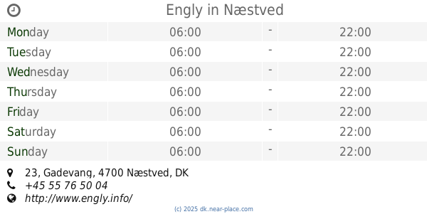
Engly
Gadevang 23, Næstved
Lodging
read more
18.535 km
Hulebækgård
Hjelmsømaglevej 61, Ringsted
Lodging
read more
19.776 km
Ellegaarden Bed and breakfast
5, Gårdrækken, Køge
Lodging
read more
20.059 km
Sørup Herregaard
Sørup Herregaard, Sørupvej 26, Ringsted
Lodging
read more
📑
all categories
Accounting
Administrative area level 1
Administrative area level 2
Airport
Amusement park
Aquarium
Art gallery
Atm
Bakery
Bank
Bar
Beauty salon
Bicycle store
Book store
Bowling alley
Bus station
Cafe
Campground
Car dealer
Car rental
Car repair
Car wash
Casino
Cemetery
Church
City hall
Clothing store
Colloquial area
Convenience store
Country
Courthouse
Dentist
Department store
Doctor
Electrician
Electronics store
Embassy
Finance
Fire station
Florist
Food
Funeral home
Furniture store
Gas station
General contractor
Grocery or supermarket
Gym
Hair care
Hardware store
Health
Hindu Temple
Home goods store
Hospital
Insurance agency
Jewelry store
Laundry
Lawyer
Library
Light rail station
Liquor store
Local government office
Locality
Locksmith
Lodging
Meal delivery
Meal takeaway
Mosque
Movie rental
Movie theater
Moving company
Museum
Natural feature
Neighborhood
Night club
Painter
Park
Parking
Pet store
Pharmacy
Physiotherapist
Place of worship
Plumber
Point of interest
Police
Political
Post office
Premise
Real estate agency
Restaurant
Roofing contractor
Route
Rv park, camping
School
Shoe store
Shopping mall
Spa
Stadium
Storage
Store
Subpremise
Subway station
Supermarket
Synagogue
Taxi stand
Train station
Transit station
Travel agency
University
Veterinary care
Zoo
sublocality level 1
sublocality level 2
↑