Gas station nearby Shell Ballerup
Denmark
Gas station nearby Shell Ballerup
Shell Ballerup
Hold-An Vej 2, Ballerup Danmark
contacts phone
:
+45
Latitude:
55.7355868
, Longitude:
12.3623267
read more
nearest Gas station
19 m
Tcb Retail ApS
Hold-An Vej 2, Ballerup
Gas station
read more
923 m
Circle K Ballerup Byvej
Ballerup Byvej 115, Ballerup
Gas station
read more
923 m
Circle K
Ballerup Byvej 115, Ballerup
Gas station
read more
1.006 km
INGO
Industriparken 2, Ballerup
Gas station
read more
1.278 km
Ok Benzin
Hold-An Vej 96, Ballerup
Gas station
read more
1.279 km
OK - Tankstation
Hold-An Vej 94, Ballerup
Gas station
read more
1.431 km
Q8 Tankstation
Vestbuen 159, Ballerup
Gas station
read more
1.691 km
Circle K Tempovej
Tempovej 25, Ballerup
Gas station
read more
1.691 km
Circle K
Tempovej 25, Ballerup
Gas station
read more
1.802 km
Ballerrup vandpost
Marbækvej 1, Ballerup
Gas station
read more
1.985 km
Shell/7-eleven, Ballerup
Hedeparken 49, Ballerup
Gas station
read more
2.007 km
Ballerup
Tempovej 1, Ballerup
Gas station
read more
2.008 km
Uno-X
Tempovej 1, Ballerup
Gas station
read more
2.642 km
F24 Tankstation
Måløv Hovedgade 1, Måløv
Gas station
read more
2.727 km
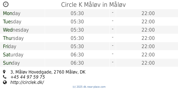
Circle K Måløv
Måløv Hovedgade 3, Måløv
Gas station
read more
3.088 km
SuperBrugsen Skovlunde
Bybjergvej 8, Skovlunde
Gas station
read more
3.092 km
OK - Tankstation
Bybjergvej 2, Skovlunde
Gas station
read more
3.092 km
OK - Tankstation
Tofthøjvej 7, Viby Sjælland
Gas station
read more
3.097 km
Circle K
Torvevej 50, Skovlunde
Gas station
read more
3.097 km
Circle K Torvevej
Torvevej 50, Skovlunde
Gas station
read more
3.109 km
Shell
Ring 4 50, Herlev
Gas station
read more
3.178 km
F24 Tankstation
Skovlunde Byvej 29, Skovlunde
Gas station
read more
3.534 km
Q8 Tankstation
Herlev Hovedgade 234-238, Herlev
Gas station
read more
3.662 km
OK - Tankstation
Tibberup Alle 67, Værløse
Gas station
read more
5.124 km
Lefre-energi ApS
Mileparken 37, Herlev
Gas station
read more
📑
all categories
Accounting
Administrative area level 1
Administrative area level 2
Airport
Amusement park
Aquarium
Art gallery
Atm
Bakery
Bank
Bar
Beauty salon
Bicycle store
Book store
Bowling alley
Bus station
Cafe
Campground
Car dealer
Car rental
Car repair
Car wash
Casino
Cemetery
Church
City hall
Clothing store
Colloquial area
Convenience store
Country
Courthouse
Dentist
Department store
Doctor
Electrician
Electronics store
Embassy
Finance
Fire station
Florist
Food
Funeral home
Furniture store
Gas station
General contractor
Grocery or supermarket
Gym
Hair care
Hardware store
Health
Hindu Temple
Home goods store
Hospital
Insurance agency
Jewelry store
Laundry
Lawyer
Library
Light rail station
Liquor store
Local government office
Locality
Locksmith
Lodging
Meal delivery
Meal takeaway
Mosque
Movie rental
Movie theater
Moving company
Museum
Natural feature
Neighborhood
Night club
Painter
Park
Parking
Pet store
Pharmacy
Physiotherapist
Place of worship
Plumber
Point of interest
Police
Political
Post office
Premise
Real estate agency
Restaurant
Roofing contractor
Route
Rv park, camping
School
Shoe store
Shopping mall
Spa
Stadium
Storage
Store
Subpremise
Subway station
Supermarket
Synagogue
Taxi stand
Train station
Transit station
Travel agency
University
Veterinary care
Zoo
sublocality level 1
sublocality level 2
↑