Gas station nearby OK - Tankstation
Denmark
Gas station nearby OK - Tankstation
OK - Tankstation
Vordingborgvej 208, Sædder, Tureby Danmark
contacts phone
:
+45
Latitude:
55.3953267
, Longitude:
12.1173969
read more
nearest Gas station
2.461 km
Shell Herfølge
Vordingborgvej 125A, Herfølge
Gas station
read more
3.506 km
Circle K Herfølge
Vordingborgvej 111, Herfølge
Gas station
read more
3.515 km
Shell
Vordingborgvej 111, Herfølge
Gas station
read more
3.518 km
Statoil Servicestation
Vordingborgvej 111, Herfølge
Gas station
read more
3.518 km
Shell Herfølge
Vordingborgvej 111, Herfølge
Gas station
read more
7.32 km
Ingo
Gymnasievej 25, Køge
Gas station
read more
7.32 km
Circle K Danmark A/S
Gymnasievej 25, Køge
Gas station
read more
8.697 km
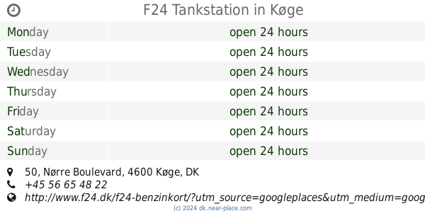
F24 Tankstation
Nørre Boulevard 50, Køge
Gas station
read more
10.252 km
OK-bz Ølbycentret
Ølbycenter, Køge
Gas station
read more
10.4 km
Circle K Københavnsvej, Køge
Københavnsvej 110, Køge
Gas station
read more
10.595 km
Shell
Københavnsvej 125, Gammel Lyngvej, Køge
Gas station
read more
10.743 km
Circle K Nordhøj, Køge
Nordhøj 4, Køge
Gas station
read more
10.915 km
OK - Tankstation
Centervej 4, Køge
Gas station
read more
11.016 km
tankpool24
Centervej 5, Køge
Gas station
read more
11.021 km
Ok A.m.b.a.
Centervej 5, Køge
Gas station
read more
11.685 km
OK - Tankstation
Ølsemaglevej 19, Køge
Gas station
read more
12.412 km
OK - Tankstation
Køgevej 1, Haslev
Gas station
read more
12.422 km
INGO Haslev
Ringstedvej 8, Haslev
Gas station
read more
12.428 km
Ok-Plus Haslev
Køgevej 1, Haslev
Gas station
read more
12.528 km
Uno-X
Gamle By 1, Haslev
Gas station
read more
12.534 km
Gamleby 1 ApS
Gamle By 1, Haslev
Gas station
read more
12.58 km
OK
Lysholm Alle 5, Haslev
Gas station
read more
13.415 km
Uno-X
Lysholm Alle 88, Haslev
Gas station
read more
13.417 km
Haslev Lysholm Allé
Lysholm Alle 88, Haslev
Gas station
read more
15.787 km
OK - Tankstation
Solrød Strandvej 150, Solrød Strand
Gas station
read more
📑
all categories
Accounting
Administrative area level 1
Administrative area level 2
Airport
Amusement park
Aquarium
Art gallery
Atm
Bakery
Bank
Bar
Beauty salon
Bicycle store
Book store
Bowling alley
Bus station
Cafe
Campground
Car dealer
Car rental
Car repair
Car wash
Casino
Cemetery
Church
City hall
Clothing store
Colloquial area
Convenience store
Country
Courthouse
Dentist
Department store
Doctor
Electrician
Electronics store
Embassy
Finance
Fire station
Florist
Food
Funeral home
Furniture store
Gas station
General contractor
Grocery or supermarket
Gym
Hair care
Hardware store
Health
Hindu Temple
Home goods store
Hospital
Insurance agency
Jewelry store
Laundry
Lawyer
Library
Light rail station
Liquor store
Local government office
Locality
Locksmith
Lodging
Meal delivery
Meal takeaway
Mosque
Movie rental
Movie theater
Moving company
Museum
Natural feature
Neighborhood
Night club
Painter
Park
Parking
Pet store
Pharmacy
Physiotherapist
Place of worship
Plumber
Point of interest
Police
Political
Post office
Premise
Real estate agency
Restaurant
Roofing contractor
Route
Rv park, camping
School
Shoe store
Shopping mall
Spa
Stadium
Storage
Store
Subpremise
Subway station
Supermarket
Synagogue
Taxi stand
Train station
Transit station
Travel agency
University
Veterinary care
Zoo
sublocality level 1
sublocality level 2
↑