Gas station nearby OK - Tankstation
Denmark
Gas station nearby OK - Tankstation
OK - Tankstation
Viborg Landevej 22, Sdr Onsild, Hobro Dänemark
contacts phone
:
+45
Latitude:
56.5863338
, Longitude:
9.7609153
read more
nearest Gas station
4.432 km
Go'on Hobro
Andrupvej 1, Hobro
Gas station
read more
5.363 km
INGO Hobro, Randersvej
Randersvej 56-58, Hobro
Gas station
read more
5.554 km
OK - Tankstation
Randersvej 20, Hobro
Gas station
read more
5.899 km
Q8 Tankstation
Markedsgade 9, Hobro
Gas station
read more
5.968 km
INGO Hobro Jyllandsvej
Jyllandsvej 11, Hobro
Gas station
read more
6.467 km
Go'on Hobro
Hostrupvej 6, Hobro
Gas station
read more
6.756 km
Uno-X
Hostrupvej 41, Hobro
Gas station
read more
7.359 km
Circle K
Aalborgvej 2, Hobro
Gas station
read more
7.364 km
Linde Terp ApS
Aalborgvej 2, Hobro
Gas station
read more
7.411 km
Go'on Benzin Fårup
Butikstorvet 3, Fårup
Gas station
read more
7.414 km
Go'on Fårup
Butikstorvet 3, Fårup
Gas station
read more
9.753 km
Uno-X Automat
Vestergade 70, Purhus, Fårup
Gas station
read more
11.218 km
Asferg Tanken v/ Asferg og Omegn Invest Aps
Vestergade 16, Fårup
Gas station
read more
11.219 km
Dagli'Brugsen Asferg
Vestergade 16,, Fårup
Gas station
read more
11.235 km
HK Benzin
Vestergade 16, Fårup
Gas station
read more
13.459 km
Shell
Terp, Hovedvejen 7, Randers
Gas station
read more
14.233 km
Go'on Råsted
Hobrovej 365, Randers NV
Gas station
read more
14.45 km
Dagli'Brugsen Bjerregrav
Bøsbrovej 1,, Randers
Gas station
read more
14.45 km
OK - Tankstation
Frederiksbergvej 1, Randers NV
Gas station
read more
15.678 km
tankpool24
Viborgvej 316, Randers NV
Gas station
read more
18.341 km
Shell
Hobrovej 181, Helsted, Randers
Gas station
read more
19.639 km
INGO
Viborgvej 100, Randers NV
Gas station
read more
20.068 km
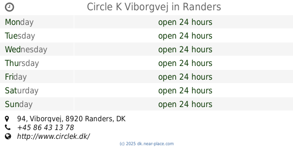
Circle K Viborgvej Randers
Viborgvej 94, Randers
Gas station
read more
20.068 km
Circle K Viborgvej
Viborgvej 94, Randers
Gas station
read more
20.068 km
Circle K Viborgvej
Viborgvej 94, Randers NV
Gas station
read more
📑
all categories
Accounting
Administrative area level 1
Administrative area level 2
Airport
Amusement park
Aquarium
Art gallery
Atm
Bakery
Bank
Bar
Beauty salon
Bicycle store
Book store
Bowling alley
Bus station
Cafe
Campground
Car dealer
Car rental
Car repair
Car wash
Casino
Cemetery
Church
City hall
Clothing store
Colloquial area
Convenience store
Country
Courthouse
Dentist
Department store
Doctor
Electrician
Electronics store
Embassy
Finance
Fire station
Florist
Food
Funeral home
Furniture store
Gas station
General contractor
Grocery or supermarket
Gym
Hair care
Hardware store
Health
Hindu Temple
Home goods store
Hospital
Insurance agency
Jewelry store
Laundry
Lawyer
Library
Light rail station
Liquor store
Local government office
Locality
Locksmith
Lodging
Meal delivery
Meal takeaway
Mosque
Movie rental
Movie theater
Moving company
Museum
Natural feature
Neighborhood
Night club
Painter
Park
Parking
Pet store
Pharmacy
Physiotherapist
Place of worship
Plumber
Point of interest
Police
Political
Post office
Premise
Real estate agency
Restaurant
Roofing contractor
Route
Rv park, camping
School
Shoe store
Shopping mall
Spa
Stadium
Storage
Store
Subpremise
Subway station
Supermarket
Synagogue
Taxi stand
Train station
Transit station
Travel agency
University
Veterinary care
Zoo
sublocality level 1
sublocality level 2
↑