Gas station nearby Go'on Holbæk
Denmark
Gas station nearby Go'on Holbæk
Go'on Holbæk
Springstrup 5, Holbæk Dänemark
contacts phone
:
+45
Latitude:
55.703435
, Longitude:
11.665323
read more
nearest Gas station
1.463 km
Retail Vestsjælland
Kalundborgvej 130, Holbæk
Gas station
read more
1.466 km
Circle K Kalundborgvej
Kalundborgvej 130, Holbæk
Gas station
read more
1.525 km
F24 Tankstation
Kalundborgvej 301, Holbæk
Gas station
read more
1.564 km
F24 Tankstation
Kalundborgvej 220, Holbæk
Gas station
read more
2.873 km
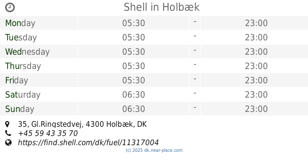
Shell
Gl.Ringstedvej 35, Holbæk
Gas station
read more
2.925 km
OK - Tankstation
Slotsvej 8, Holbæk
Gas station
read more
2.971 km
Cirkel K
Valdemar Sejrsvej 6, Holbæk
Gas station
read more
2.973 km
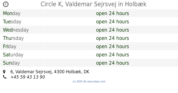
Circle K, Valdemar Sejrsvej
Valdemar Sejrsvej 6, Holbæk
Gas station
read more
2.988 km
Go'on Holbæk
Spånnebæk 1, Holbæk
Gas station
read more
2.989 km
Retail Vestsjælland
Valdemar Sejrsvej 6, Holbæk
Gas station
read more
3.14 km
INGO
L. C. Worsøesvej 1, Holbæk
Gas station
read more
3.151 km
Holbæk KP Danøsvej
K. P. Danøsvej 2, Holbæk
Gas station
read more
3.156 km
Bonus
K. P. Danøsvej 2, Holbæk
Gas station
read more
3.466 km
Uno-X
Roskildevej 21, Holbæk
Gas station
read more
3.469 km
Holbæk Roskildevej
Roskildevej 21, Holbæk
Gas station
read more
3.904 km
Circle K Roskildevej
Roskildevej 195, Holbæk
Gas station
read more
3.904 km
Circle K Roskildevej, Køge
Roskildevej 195, Holbæk
Gas station
read more
4.402 km
F24 Tankstation
Munkholmvej 53, Holbæk
Gas station
read more
4.839 km
Hydro Texaco Holbæk
Munkholmvej 107,, Holbæk
Gas station
read more
4.846 km
Bonus Tankstation
Munkholmvej 107, Holbæk
Gas station
read more
5.756 km
1-2-3 Vipperød
Roskildevej 268B, Vipperød
Gas station
read more
5.759 km
123 Benzin
Roskildevej 268, Vipperød
Gas station
read more
8.128 km
OK - Tankstation
Byvej 37, Gislinge
Gas station
read more
8.984 km
Dagli'Brugsen Kundby
Bygaden 32,, Svinninge
Gas station
read more
14.518 km
OK - Tankstation
Torvet 20, Ølgod
Gas station
read more
📑
all categories
Accounting
Administrative area level 1
Administrative area level 2
Airport
Amusement park
Aquarium
Art gallery
Atm
Bakery
Bank
Bar
Beauty salon
Bicycle store
Book store
Bowling alley
Bus station
Cafe
Campground
Car dealer
Car rental
Car repair
Car wash
Casino
Cemetery
Church
City hall
Clothing store
Colloquial area
Convenience store
Country
Courthouse
Dentist
Department store
Doctor
Electrician
Electronics store
Embassy
Finance
Fire station
Florist
Food
Funeral home
Furniture store
Gas station
General contractor
Grocery or supermarket
Gym
Hair care
Hardware store
Health
Hindu Temple
Home goods store
Hospital
Insurance agency
Jewelry store
Laundry
Lawyer
Library
Light rail station
Liquor store
Local government office
Locality
Locksmith
Lodging
Meal delivery
Meal takeaway
Mosque
Movie rental
Movie theater
Moving company
Museum
Natural feature
Neighborhood
Night club
Painter
Park
Parking
Pet store
Pharmacy
Physiotherapist
Place of worship
Plumber
Point of interest
Police
Political
Post office
Premise
Real estate agency
Restaurant
Roofing contractor
Route
Rv park, camping
School
Shoe store
Shopping mall
Spa
Stadium
Storage
Store
Subpremise
Subway station
Supermarket
Synagogue
Taxi stand
Train station
Transit station
Travel agency
University
Veterinary care
Zoo
sublocality level 1
sublocality level 2
↑