Gas station nearby Express Hjørring 2
Denmark
Gas station nearby Express Hjørring 2
Express Hjørring 2
40, Frederikshavnsvej, 9800, Hjørring, DK Danmark
contacts phone
:
+45 96 34 03 42
Latitude:
57.455611
, Longitude:
10.0040069
larger map & directions
read more
nearest Gas station
3 m
INGO
Frederikshavnsvej 40, Hjørring
Gas station
read more
36 m
OK Hjørring
Frederikshavnsvej 31,, Hjørring
Gas station
read more
40 m
OK - Tankstation
Frederikshavnsvej 31, Hjørring
Gas station
read more
182 m
Statoil Fr. Havnsvej.
Frederikshavnsvej 9, Hjørring
Gas station
read more
182 m
Circle K
Frederikshavnsvej 9, Hjørring
Gas station
read more
767 m
Circle K Ringvejen
Ringvejen 2, Hjørring
Gas station
read more
767 m
Circle K Ringvejen
Heerfordtsvej 2, Hjørring
Gas station
read more
784 m
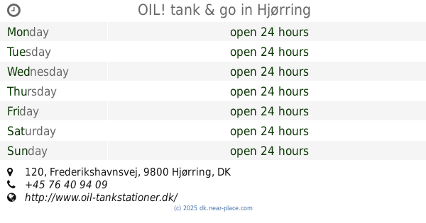
OIL! tank & go
Frederikshavnsvej 120, Hjørring
Gas station
read more
790 m
Shell Hjørring Ringvejen
Heerfordtsvej 2, Hjørring
Gas station
read more
811 m
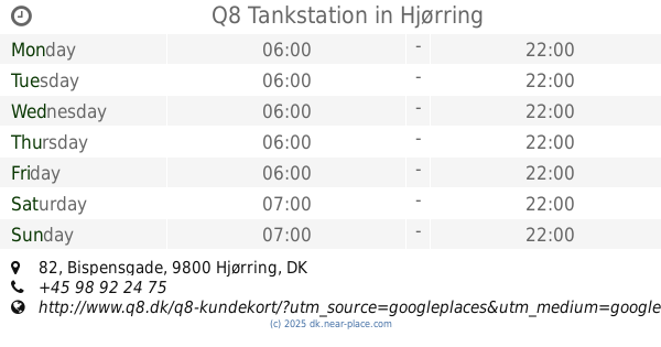
Q8 Tankstation
Bispensgade 82, Hjørring
Gas station
read more
903 m
1-2-3 Hjørring
Bispensgade 87, Hjørring
Gas station
read more
973 m
INGO
Bispensgade 97, Hjørring
Gas station
read more
991 m
INGO
A F Heidemanns Vej 3, Hjørring
Gas station
read more
996 m
Express Hjørring
A F Heidemanns Vej 3, Hjørring
Gas station
read more
1.429 km
Go'on Hjørring
Tørholmsvej 95, Hjørring
Gas station
read more
2.247 km
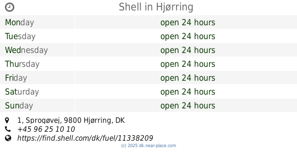
Shell
Sprogøvej 1, Hjørring
Gas station
read more
2.286 km
Uno-X - Hjørring
Hirtshalsvej 38,, Hjørring
Gas station
read more
2.287 km
Bonus
Hirtshalsvej 38, Hjørring
Gas station
read more
2.415 km
OK Tankstation
Nordbovej 2, Hjørring
Gas station
read more
2.455 km
Go'on Hjørring
Ålborgvej 88, Hjørring
Gas station
read more
3.051 km
Bonus
Skagensvej 201, Hjørring
Gas station
read more
3.099 km
Højene
Skagensvej 201, Hjørring
Gas station
read more
8.886 km
OK - Tankstation
Gl Landevej 7, Hirtshals
Gas station
read more
11.095 km
OK - Tankstation
Sigenvej 3, Vrå
Gas station
read more
11.981 km
F24 Tankstation
Nørregade 21, Sindal
Gas station
read more
📑
all categories
Accounting
Administrative area level 1
Administrative area level 2
Airport
Amusement park
Aquarium
Art gallery
Atm
Bakery
Bank
Bar
Beauty salon
Bicycle store
Book store
Bowling alley
Bus station
Cafe
Campground
Car dealer
Car rental
Car repair
Car wash
Casino
Cemetery
Church
City hall
Clothing store
Colloquial area
Convenience store
Country
Courthouse
Dentist
Department store
Doctor
Electrician
Electronics store
Embassy
Finance
Fire station
Florist
Food
Funeral home
Furniture store
Gas station
General contractor
Grocery or supermarket
Gym
Hair care
Hardware store
Health
Hindu Temple
Home goods store
Hospital
Insurance agency
Jewelry store
Laundry
Lawyer
Library
Light rail station
Liquor store
Local government office
Locality
Locksmith
Lodging
Meal delivery
Meal takeaway
Mosque
Movie rental
Movie theater
Moving company
Museum
Natural feature
Neighborhood
Night club
Painter
Park
Parking
Pet store
Pharmacy
Physiotherapist
Place of worship
Plumber
Point of interest
Police
Political
Post office
Premise
Real estate agency
Restaurant
Roofing contractor
Route
Rv park, camping
School
Shoe store
Shopping mall
Spa
Stadium
Storage
Store
Subpremise
Subway station
Supermarket
Synagogue
Taxi stand
Train station
Transit station
Travel agency
University
Veterinary care
Zoo
sublocality level 1
sublocality level 2
↑