Church nearby Kattrup Kirke
Denmark
Church nearby Kattrup Kirke
Kattrup Kirke
Danmark, Gl Tebstrupvej 2K, Hovedgård Dinamarca
contacts phone
:
+45
Latitude:
55.9522885
, Longitude:
9.9186395
read more
nearest Church
4.888 km
Hylke Kirche
Fårbjergvej 10, Skanderborg
Church
read more
4.888 km
Hylke Kirke
Fårbjergvej 10, Skanderborg
Church
read more
6.123 km
Serridslev Kirke
Serridslevvej 15, Horsens
Church
read more
7.295 km
Vær Nebel Kirkekontor
Værvej 48, Horsens
Church
read more
7.955 km
Hansted Church
Danmark, Stængervej 3B, Horsens
Church
read more
8.358 km
Skanderborg Schlosskirche
Slotsholmen 4, Skanderborg
Church
read more
8.766 km
Torrild Church
Bygaden 2, Odder
Church
read more
10.162 km
The Church of Jesus Christ of Latter-day Saints
Margrethevej 6, Horsens
Church
read more
10.813 km
Sct Josefs Kirke
Nørregade 19, Horsens
Church
read more
10.813 km
Sankt Josefs Kirke
Nørregade 19, Horsens
Church
read more
10.84 km
Kirkecenter Højvangen
Mallinggårdsvej 3, Skanderborg
Church
read more
10.85 km
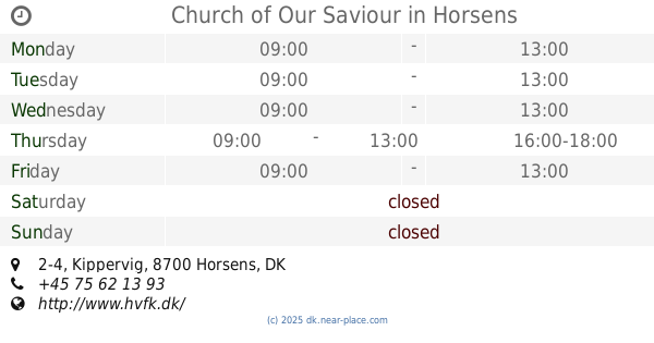
Church of Our Saviour
Kippervig 2-4, Horsens
Church
read more
12.482 km
Pinsekirken Elim
Sverigesvej 29, Horsens
Church
read more
13.918 km
Østerhåb Kirke
Gravengårdsvej 10, Horsens
Church
read more
14.287 km
Ørting Church
Bilsbækvej 36, Odder
Church
read more
14.304 km
Ørting Sognegård
Bilsbækvej 34B, Odder
Church
read more
14.515 km
Hatting Kirke
Kirkebakken 4, Horsens
Church
read more
14.568 km
Odder Freie Evangelische Gemeinde
Banegårdsgade 5, Odder
Church
read more
14.649 km
Astrup Kirke
Østergårdsvek 225, Solbjerg
Church
read more
14.731 km
Odder Church
Kirkesti 3, Odder
Church
read more
14.732 km
Odder Sognekirke
Kirkesti 1, Odder
Church
read more
15.14 km
Odder Grundtvigske Valgmenighed
Rørthvej 34, Odder
Church
read more
15.14 km
Odder Valgmenighedskirke
Rørthvej 34, Odder
Church
read more
16.59 km
Tiset Kirke
Ravnholtvej 2, Solbjerg
Church
read more
17.376 km
Ølsted Kirke
Ny Kirkevej 22, Løsning
Church
read more
📑
all categories
Accounting
Administrative area level 1
Administrative area level 2
Airport
Amusement park
Aquarium
Art gallery
Atm
Bakery
Bank
Bar
Beauty salon
Bicycle store
Book store
Bowling alley
Bus station
Cafe
Campground
Car dealer
Car rental
Car repair
Car wash
Casino
Cemetery
Church
City hall
Clothing store
Colloquial area
Convenience store
Country
Courthouse
Dentist
Department store
Doctor
Electrician
Electronics store
Embassy
Finance
Fire station
Florist
Food
Funeral home
Furniture store
Gas station
General contractor
Grocery or supermarket
Gym
Hair care
Hardware store
Health
Hindu Temple
Home goods store
Hospital
Insurance agency
Jewelry store
Laundry
Lawyer
Library
Light rail station
Liquor store
Local government office
Locality
Locksmith
Lodging
Meal delivery
Meal takeaway
Mosque
Movie rental
Movie theater
Moving company
Museum
Natural feature
Neighborhood
Night club
Painter
Park
Parking
Pet store
Pharmacy
Physiotherapist
Place of worship
Plumber
Point of interest
Police
Political
Post office
Premise
Real estate agency
Restaurant
Roofing contractor
Route
Rv park, camping
School
Shoe store
Shopping mall
Spa
Stadium
Storage
Store
Subpremise
Subway station
Supermarket
Synagogue
Taxi stand
Train station
Transit station
Travel agency
University
Veterinary care
Zoo
sublocality level 1
sublocality level 2
↑