Church nearby Engum Kirke
Denmark
Church nearby Engum Kirke
Engum Kirke
118, Engumvej, 7120, Vejle, DK Denmark
contacts phone
:
+45
Latitude:
55.740912
, Longitude:
9.658141
larger map & directions
read more
nearest Church
3.422 km
Vejlefjordkirken
Vejlefjordskolen, 27, Daugård
Church
read more
3.926 km
Daugård Kirke
Svends Møllevej 4, Daugård
Church
read more
4.032 km
Missionshuset i Bredballe
Bredballe Byvej 59, Vejle Ø
Church
read more
4.117 km
Frikirken En Åben Dør
Håndværkervej 1B, Vejle Ø
Church
read more
4.285 km
Bredballe Church and Cemeteries
Kirkebakken 46, Vejle Ø
Church
read more
4.285 km
Bredballe Kirke og Kirkegårde
Kirkebakken 46, Vejle Ø
Church
read more
4.298 km
Hedensted kirke
Kirkegade 1, Hedensted
Church
read more
4.3 km
Bredballe Church
Kirkebakken 32, Vejle Ø
Church
read more
5.408 km
Hedensted Valgmenighed
Kløvervej 13, Hedensted
Church
read more
5.441 km
Ørum Kirke
Kirkebuen 2, Daugård
Church
read more
5.93 km
Vejle Frimenighed
Niels Finsensvej 18, Vejle
Church
read more
7.886 km
Grejsdal Church
Grejsdalsvej 221, Vejle
Church
read more
8.245 km
Bykirken i Vejle
Grejsdalsvej 16, Vejle
Church
read more
8.438 km
Sct. Pouls Kirke - Metodistkirken Vejle
Vissingsgade 15A, Vejle
Church
read more
8.714 km
Sct. Norberts Kirke
Fjellegade 2, Vejle
Church
read more
8.714 km
Skt. Norberts Kirche
Fjellegade 2, Vejle
Church
read more
9.112 km
Sindbjerg kirke
Riberlundvej 1, Vejle
Church
read more
11.082 km
Stenderup Kirke
Hedenstedvej 1K, Stenderup
Church
read more
11.541 km
Vrigsted kirke
Koksfourt 1K, Stouby
Church
read more
14.249 km
Hatting Kirke
Kirkebakken 4, Horsens
Church
read more
14.733 km
Østerhåb Kirke
Gravengårdsvej 10, Horsens
Church
read more
15.096 km
Egeskov Kirke
Vejlby Kirkevej 55, Fredericia
Church
read more
18.108 km
Sankt Josefs Kirke
Nørregade 19, Horsens
Church
read more
18.108 km
Sct Josefs Kirke
Nørregade 19, Horsens
Church
read more
18.121 km
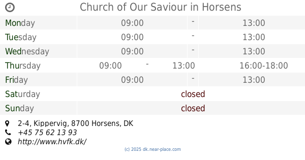
Church of Our Saviour
Kippervig 2-4, Horsens
Church
read more
📑
all categories
Accounting
Administrative area level 1
Administrative area level 2
Airport
Amusement park
Aquarium
Art gallery
Atm
Bakery
Bank
Bar
Beauty salon
Bicycle store
Book store
Bowling alley
Bus station
Cafe
Campground
Car dealer
Car rental
Car repair
Car wash
Casino
Cemetery
Church
City hall
Clothing store
Colloquial area
Convenience store
Country
Courthouse
Dentist
Department store
Doctor
Electrician
Electronics store
Embassy
Finance
Fire station
Florist
Food
Funeral home
Furniture store
Gas station
General contractor
Grocery or supermarket
Gym
Hair care
Hardware store
Health
Hindu Temple
Home goods store
Hospital
Insurance agency
Jewelry store
Laundry
Lawyer
Library
Light rail station
Liquor store
Local government office
Locality
Locksmith
Lodging
Meal delivery
Meal takeaway
Mosque
Movie rental
Movie theater
Moving company
Museum
Natural feature
Neighborhood
Night club
Painter
Park
Parking
Pet store
Pharmacy
Physiotherapist
Place of worship
Plumber
Point of interest
Police
Political
Post office
Premise
Real estate agency
Restaurant
Roofing contractor
Route
Rv park, camping
School
Shoe store
Shopping mall
Spa
Stadium
Storage
Store
Subpremise
Subway station
Supermarket
Synagogue
Taxi stand
Train station
Transit station
Travel agency
University
Veterinary care
Zoo
sublocality level 1
sublocality level 2
↑