Car repair nearby Autodoktoren
Denmark
Car repair nearby Autodoktoren
Autodoktoren
Kollerød Bygade 25, Lillerød Dänemark
contacts phone
:
+45
Latitude:
55.8643705
, Longitude:
12.2952764
read more
nearest Car repair
1.534 km
Lynge Auto
Nørre-Herlevvej 3, Lynge
Car repair
read more
1.54 km
Tommis Auto
Nørre-Herlevvej 3, Lynge
Car repair
read more
2.969 km
Allerød Auto ApS
Gl Lyngevej 119, Lillerød
Car repair
read more
2.977 km
Martin Frank Reifling
Skolelodden 2, Lillerød
Car repair
read more
3.139 km
CC Auto Allerød
Høveltsvangsvej 31, Lillerød
Car repair
read more
3.152 km
Bilmaatten.dk
Enghavegårdsvej 16, Hillerød
Car repair
read more
3.248 km
Flemmings Autoservice
Gl Lyngevej 12, Lillerød
Car repair
read more
3.457 km
Elkjærs Autolakcenter ApS
Granlyet 2, Lynge
Car repair
read more
3.466 km
Wendts Auto
Vassingerød Bygade 46, Lynge
Car repair
read more
3.812 km
SPS AUTOOPHUG APS
Industriskellet 8, Lynge
Car repair
read more
3.812 km
SPS AUTOOPHUG
Industriskellet 8, Lynge
Car repair
read more
3.86 km
CP's Garage
Smedevangen 4, Lynge
Car repair
read more
4.049 km
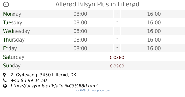
Allerød Bilsyn Plus
Gydevang 2, Lillerød
Car repair
read more
4.059 km
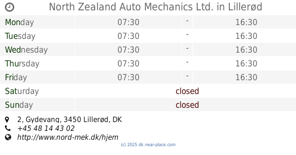
North Zealand Auto Mechanics Ltd.
Gydevang 2, Lillerød
Car repair
read more
4.159 km
Pwheels
Vassingerødvej 109, Lynge
Car repair
read more
4.262 km
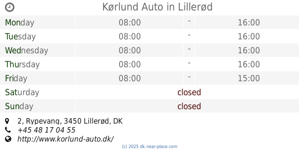
Kørlund Auto
Rypevang 2, Lillerød
Car repair
read more
4.46 km
Bilhuset Allerød ApS
Solvang 1-3, Lillerød
Car repair
read more
4.512 km
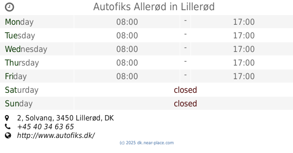
Autofiks Allerød
Solvang 2, Lillerød
Car repair
read more
4.516 km
Bilsyndanmark ApS
Solvang 2, Lillerød
Car repair
read more
4.89 km
Kentek Auto
Lindholmvej 13c, Slangerup
Car repair
read more
4.89 km
Protec Autoservice
Lindholmvej 13, Slangerup
Car repair
read more
6.358 km
Farum Synshal ApS
Farum Gydevej 89, Farum
Car repair
read more
6.382 km
Ivar Jensen Autogummi A/S
Farum Gydevej 91, Farum
Car repair
read more
6.587 km
Furesø Auto ApS
Hørmarken 8, Farum
Car repair
read more
6.663 km
Bagsværd - Farum Industrilakering V/alex Hindborg Jensen
Bygmarken 21 A, Farum
Car repair
read more
📑
all categories
Accounting
Administrative area level 1
Administrative area level 2
Airport
Amusement park
Aquarium
Art gallery
Atm
Bakery
Bank
Bar
Beauty salon
Bicycle store
Book store
Bowling alley
Bus station
Cafe
Campground
Car dealer
Car rental
Car repair
Car wash
Casino
Cemetery
Church
City hall
Clothing store
Colloquial area
Convenience store
Country
Courthouse
Dentist
Department store
Doctor
Electrician
Electronics store
Embassy
Finance
Fire station
Florist
Food
Funeral home
Furniture store
Gas station
General contractor
Grocery or supermarket
Gym
Hair care
Hardware store
Health
Hindu Temple
Home goods store
Hospital
Insurance agency
Jewelry store
Laundry
Lawyer
Library
Light rail station
Liquor store
Local government office
Locality
Locksmith
Lodging
Meal delivery
Meal takeaway
Mosque
Movie rental
Movie theater
Moving company
Museum
Natural feature
Neighborhood
Night club
Painter
Park
Parking
Pet store
Pharmacy
Physiotherapist
Place of worship
Plumber
Point of interest
Police
Political
Post office
Premise
Real estate agency
Restaurant
Roofing contractor
Route
Rv park, camping
School
Shoe store
Shopping mall
Spa
Stadium
Storage
Store
Subpremise
Subway station
Supermarket
Synagogue
Taxi stand
Train station
Transit station
Travel agency
University
Veterinary care
Zoo
sublocality level 1
sublocality level 2
↑