Cafe nearby Rytterknægten
Denmark
Cafe nearby Rytterknægten
Rytterknægten
Marienborgvej 28, Randers NØ Danmark
contacts phone
:
+45
Latitude:
56.4754203
, Longitude:
10.0460987
read more
nearest Cafe
1.14 km
Café Rusfri
Gammel Hadsundvej 3, Randers C
Cafe
read more
1.196 km
Frappeeze Café
Rådmands Boulevard 5, Randers C
Cafe
read more
1.196 km
Frappeeze Café
Rådmands Boulevard 5, Randers
Cafe
read more
1.472 km
Café Sven Dalsgaard
Mariagervej 6, Randers C
Cafe
read more
1.541 km
Frivillighuset Randers
C, Østergade 11-13, Randers C
Cafe
read more
1.602 km
Café Jens Otto
Stemannsgade 9C, Randers C
Cafe
read more
1.631 km
Cafe Toscana Randers
Østervold 21, Randers C
Cafe
read more
1.634 km
Randers Vandpibecafé
Stemannsgade 9, Randers C
Cafe
read more
1.693 km
Kulturcafeen v/Karen Margrethe Jensen
Stemannsgade 2, Randers C
Cafe
read more
1.741 km
Coiffeur N
Houmeden 2, Randers C
Cafe
read more
1.742 km
Lagkage Huset
Torvegade
Cafe
read more
1.757 km
Café Blicher ApS
Gråbrødrestræde 7, Randers C
Cafe
read more
1.764 km
Jørgens Café
Slotspladsen 8, Randers C
Cafe
read more
1.769 km
Café Borgen
Houmeden 10, Randers C
Cafe
read more
1.782 km
Cafe Hugo
Brødregade 8, Randers C
Cafe
read more
1.794 km
Cafe Corner
Houmeden 17, Randers C
Cafe
read more
1.811 km
Cafe Kræs
Kirketorvet 8, Randers C
Cafe
read more
1.833 km
Café von Hatten
Von Hattenstræde 7, Randers C
Cafe
read more
1.865 km
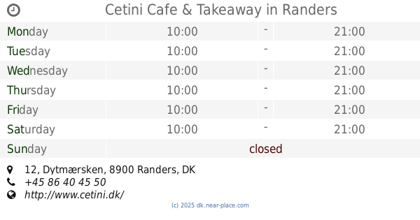
Cetini Cafe & Takeaway
Dytmærsken 12, Randers C
Cafe
read more
1.873 km
Vestergades Cafe V/ole Bjerg-jørgensen
Vestergade 8, Randers C
Cafe
read more
1.934 km
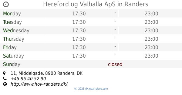
Hereford og Valhalla ApS
Middelgade 11, Randers C
Cafe
read more
1.988 km
Cafe K
Storegade 8, Randers C
Cafe
read more
4.968 km
Hos Anne Marie
Messingvej 74, Randers SV
Cafe
read more
5.176 km
JOE & THE JUICE
Merkurvej 55, Randers SØ
Cafe
read more
5.2 km
Café Fry Randers ApS
55 Merkurvej, Randers SØ
Cafe
read more
📑
all categories
Accounting
Administrative area level 1
Administrative area level 2
Airport
Amusement park
Aquarium
Art gallery
Atm
Bakery
Bank
Bar
Beauty salon
Bicycle store
Book store
Bowling alley
Bus station
Cafe
Campground
Car dealer
Car rental
Car repair
Car wash
Casino
Cemetery
Church
City hall
Clothing store
Colloquial area
Convenience store
Country
Courthouse
Dentist
Department store
Doctor
Electrician
Electronics store
Embassy
Finance
Fire station
Florist
Food
Funeral home
Furniture store
Gas station
General contractor
Grocery or supermarket
Gym
Hair care
Hardware store
Health
Hindu Temple
Home goods store
Hospital
Insurance agency
Jewelry store
Laundry
Lawyer
Library
Light rail station
Liquor store
Local government office
Locality
Locksmith
Lodging
Meal delivery
Meal takeaway
Mosque
Movie rental
Movie theater
Moving company
Museum
Natural feature
Neighborhood
Night club
Painter
Park
Parking
Pet store
Pharmacy
Physiotherapist
Place of worship
Plumber
Point of interest
Police
Political
Post office
Premise
Real estate agency
Restaurant
Roofing contractor
Route
Rv park, camping
School
Shoe store
Shopping mall
Spa
Stadium
Storage
Store
Subpremise
Subway station
Supermarket
Synagogue
Taxi stand
Train station
Transit station
Travel agency
University
Veterinary care
Zoo
sublocality level 1
sublocality level 2
↑