Bar nearby Louise og Per Stenberg
Denmark
Bar nearby Louise og Per Stenberg
Louise og Per Stenberg
35, Sikavej, 4623, Lille Skensved, DK Dania
contacts phone
:
+45 60 19 18 98
Latitude:
55.485539
, Longitude:
12.0749222
larger map & directions
read more
nearest Bar
19 m
wine-dine.dk
Sikavej 37, Lille Skensved
Bar
read more
4.902 km
Provstens Vinstue
Hovedgaden 20, Lille Skensved
Bar
read more
6.371 km
Mie's Cafe
Ølbycenter 13, Køge
Bar
read more
6.607 km
MC 19 Køge
Egedesvej 32, Lille Skensved
Bar
read more
6.91 km
Ellemarkens Bodega Drøvlen
Parkvej 26, Køge
Bar
read more
7.263 km
Vin-O
Vestergade 19A, Køge
Bar
read more
7.274 km
RICHTERs Ølstue
Vestergade 16, Køge
Bar
read more
7.287 km
Parquing
Vestergade 15D, Køge
Bar
read more
7.477 km
Bodega Slap A
Nørregade 34, Køge
Bar
read more
7.561 km
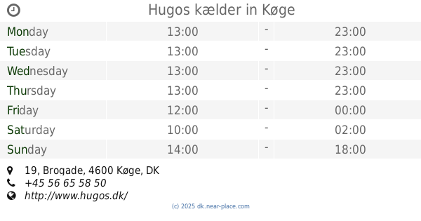
Hugos kælder
Brogade 19, Køge
Bar
read more
7.867 km
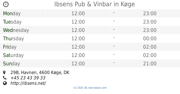
Ibsens Pub & Vinbar
Havnen 29B, Køge
Bar
read more
7.881 km
Old Irish Pub
Havnen 31, Køge
Bar
read more
8.945 km
Herfølge Bodega
Vordingborgvej 125B, Herfølge
Bar
read more
8.966 km
Herfølge Bodega
125, Vordingborgvej, Herfølge
Bar
read more
10.386 km
Solrød Center Pub ApS
Solrød Center 34, Solrød Strand
Bar
read more
13.143 km
Jesper Hansen
Karlslunde Centervej 25, Tune
Bar
read more
13.197 km
Olsens Bar
Stevnsvej 33, Køge
Bar
read more
13.389 km
Hos Olsens - Æbler, Bryggeri og Bistro
Hovedvejen 6, Roskilde
Bar
read more
18.27 km
Købmanden - SMØRREBRØD
Rønnedevej 13, Ringsted
Bar
read more
25.908 km
City Pub Albertslund
Bygangen 2, Albertslund
Bar
read more
26.916 km
Vinos Denmark
Vallensbækvej 6, Brøndbyvester
Bar
read more
27.41 km
HDCC MC - Motorcykel klub
Sydvestvej 81, Glostrup
Bar
read more
31.372 km
United MC
Nyholms Alle 40, Rødovre
Bar
read more
32.234 km
S BAR
Rødovre Parkvej 150, Rødovre
Bar
read more
33.436 km
Carl's Old Inn v/Leif Wistisen
Rødovrevej 260, Rødovre
Bar
read more
📑
all categories
Accounting
Administrative area level 1
Administrative area level 2
Airport
Amusement park
Aquarium
Art gallery
Atm
Bakery
Bank
Bar
Beauty salon
Bicycle store
Book store
Bowling alley
Bus station
Cafe
Campground
Car dealer
Car rental
Car repair
Car wash
Casino
Cemetery
Church
City hall
Clothing store
Colloquial area
Convenience store
Country
Courthouse
Dentist
Department store
Doctor
Electrician
Electronics store
Embassy
Finance
Fire station
Florist
Food
Funeral home
Furniture store
Gas station
General contractor
Grocery or supermarket
Gym
Hair care
Hardware store
Health
Hindu Temple
Home goods store
Hospital
Insurance agency
Jewelry store
Laundry
Lawyer
Library
Light rail station
Liquor store
Local government office
Locality
Locksmith
Lodging
Meal delivery
Meal takeaway
Mosque
Movie rental
Movie theater
Moving company
Museum
Natural feature
Neighborhood
Night club
Painter
Park
Parking
Pet store
Pharmacy
Physiotherapist
Place of worship
Plumber
Point of interest
Police
Political
Post office
Premise
Real estate agency
Restaurant
Roofing contractor
Route
Rv park, camping
School
Shoe store
Shopping mall
Spa
Stadium
Storage
Store
Subpremise
Subway station
Supermarket
Synagogue
Taxi stand
Train station
Transit station
Travel agency
University
Veterinary care
Zoo
sublocality level 1
sublocality level 2
↑