Bar nearby Bryggerkælderen
Denmark
Bar nearby Bryggerkælderen
Bryggerkælderen
36, Bryggertorvet, 3650, Ølstykke, DK Denmark
contacts phone
:
+45 47 17 63 44
Latitude:
55.7810671
, Longitude:
12.1741011
larger map & directions
read more
nearest Bar
1.934 km
Mikeys Pub
Egedal Centret 9, Stenløse
Bar
read more
3.149 km
emil høstbo
Ll Petersborgvej 1, Stenløse
Bar
read more
3.79 km
Søsum Bryghus
Brunhøjvej 5, Veksø
Bar
read more
5.379 km
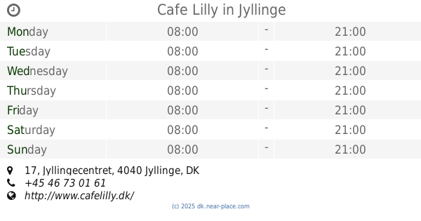
Cafe Lilly
Jyllingecentret 17, Jyllinge
Bar
read more
5.693 km
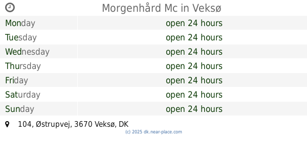
Morgenhård Mc
Østrupvej 104, Veksø
Bar
read more
7.045 km
Pub "På Hjørnet"
Stationsvej 5, Slangerup
Bar
read more
9.651 km
The British Pub
Østergade 12, Frederikssund
Bar
read more
11.646 km
Gørløse Pizza And Snack
Hovedvejen 21 B, Gørløse
Bar
read more
11.646 km
Gørløse Pizza Og Grillbar
Hovedvejen 21 B, Gørløse
Bar
read more
11.72 km
Ol'timers MC Ballerup
Råmosevej 62, Ballerup
Bar
read more
12.456 km
Værløse Center Pub v / Gert Christian Sluth
Bymidten 64, Værløse
Bar
read more
12.456 km
Værløse Center Pub
Bymidten 64, Værløse
Bar
read more
13.002 km
Ballerup Bodega
Sankt Jacobsvej 3, Ballerup
Bar
read more
14.144 km
Pink Panther MC Danmark
Borupvej 57B, Skævinge
Bar
read more
16.405 km
Residents tavern "The Wet Hen"
Morbærhaven 5, Albertslund
Bar
read more
16.405 km
Beboerværtshuset "Den Våde Høne"
Morbærhaven 5, Albertslund
Bar
read more
16.518 km
Kildedalen 65
Kildedalen 65, Hillerød
Bar
read more
16.58 km
Finn Inn
77, Taastrup Hovedgade, Taastrup
Bar
read more
16.587 km
Bowlerhatten
Jægerhusene 26, Albertslund
Bar
read more
16.821 km
Pinball Glostrup
Formervangen 6, Glostrup
Bar
read more
17.875 km
City Pub Albertslund
Bygangen 2, Albertslund
Bar
read more
17.896 km
Krostuen DIK
Vognporten 14, Albertslund
Bar
read more
18.361 km
Glostrup Kina Grill
Diget 26, Glostrup
Bar
read more
18.511 km
HDCC MC - Motorcykel klub
Sydvestvej 81, Glostrup
Bar
read more
18.82 km
Quickplay Danmark
Gadager 135, Glostrup
Bar
read more
📑
all categories
Accounting
Administrative area level 1
Administrative area level 2
Airport
Amusement park
Aquarium
Art gallery
Atm
Bakery
Bank
Bar
Beauty salon
Bicycle store
Book store
Bowling alley
Bus station
Cafe
Campground
Car dealer
Car rental
Car repair
Car wash
Casino
Cemetery
Church
City hall
Clothing store
Colloquial area
Convenience store
Country
Courthouse
Dentist
Department store
Doctor
Electrician
Electronics store
Embassy
Finance
Fire station
Florist
Food
Funeral home
Furniture store
Gas station
General contractor
Grocery or supermarket
Gym
Hair care
Hardware store
Health
Hindu Temple
Home goods store
Hospital
Insurance agency
Jewelry store
Laundry
Lawyer
Library
Light rail station
Liquor store
Local government office
Locality
Locksmith
Lodging
Meal delivery
Meal takeaway
Mosque
Movie rental
Movie theater
Moving company
Museum
Natural feature
Neighborhood
Night club
Painter
Park
Parking
Pet store
Pharmacy
Physiotherapist
Place of worship
Plumber
Point of interest
Police
Political
Post office
Premise
Real estate agency
Restaurant
Roofing contractor
Route
Rv park, camping
School
Shoe store
Shopping mall
Spa
Stadium
Storage
Store
Subpremise
Subway station
Supermarket
Synagogue
Taxi stand
Train station
Transit station
Travel agency
University
Veterinary care
Zoo
sublocality level 1
sublocality level 2
↑