Bakery nearby Brdr. Rask Bageri og Konditori
Denmark
Bakery nearby Brdr. Rask Bageri og Konditori
Brdr. Rask Bageri og Konditori
Banegaardsvej 29, Hobro Denmark
contacts phone
:
+45
Latitude:
56.6445837
, Longitude:
9.7871758
read more
nearest Bakery
1.519 km
MyBakery
Mariagervej 2, Hobro
Bakery
read more
2.769 km
Bæchs Conditori A/S
Langelandsvej 1, Hobro
Bakery
read more
21.947 km
Helsted Bageren
Helstedvej 1, Randers NV
Bakery
read more
23.633 km
Hornbæk Bageri Randers
Fladbrovej 21, Randers NV
Bakery
read more
23.633 km
Hornbæk Bakery Randers
Fladbrovej 21, Randers NV
Bakery
read more
23.733 km
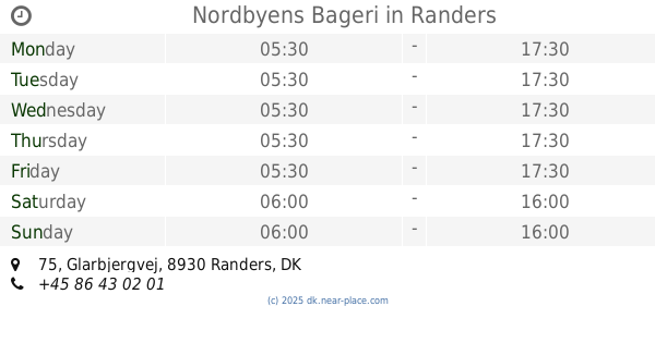
Nordbyens Bageri
Glarbjergvej 75, Randers NØ
Bakery
read more
24.282 km
Boulevardbageriet V/Henrik Sørensen
Hobrovej 63, Randers NV
Bakery
read more
24.282 km
The bakery Boulevard V / Henrik Sørensen
Hobrovej 63, Randers NV
Bakery
read more
25.673 km
Underværkets Bageri V/gafur Pervizaj
Stemannsgade 9 C, Randers
Bakery
read more
25.717 km
Brødværkstedet
Udbyhøjvej 85, Randers NØ
Bakery
read more
26.685 km
Frederiksberg Bageri
Bøsbrovej 7, Randers SV
Bakery
read more
26.898 km
Løgstørvejens Bageri
Løgstørvej 13, Randers SV
Bakery
read more
26.898 km
Guldbageren Randers
Løgstørvej 13, Randers SV
Bakery
read more
27.647 km
Vorup Bakery Ltd.
Skanderborggade 45, Randers SV
Bakery
read more
27.647 km
Vorup Bageri ApS
Skanderborggade 45, Randers SV
Bakery
read more
27.749 km
Vennelyst Bageri
Vennelystvej 56A, Randers SØ
Bakery
read more
29.07 km
Houlkær Bageri
Odshøjvej 1A, Viborg
Bakery
read more
30.632 km
Morgenbassen
Randersvej 11, Viborg
Bakery
read more
31.377 km
Bakery By Doktor
Farvervej 2, Viborg
Bakery
read more
31.575 km
Søster Lagkage
Gravene 43, Viborg
Bakery
read more
31.717 km
Hartvigs bageri
Vestergade 12, Viborg
Bakery
read more
32.046 km
Lagkagehuset
Jegstrupvej 16, Viborg
Bakery
read more
34.197 km
Søndermarkens Bager
Koldingvej 130, Viborg
Bakery
read more
34.2 km
Søndermarkens Bager Aps
Koldingvej 130, Viborg
Bakery
read more
45.05 km
Bogø Sandwich
Bogøgade 2, Aalborg
Bakery
read more
📑
all categories
Accounting
Administrative area level 1
Administrative area level 2
Airport
Amusement park
Aquarium
Art gallery
Atm
Bakery
Bank
Bar
Beauty salon
Bicycle store
Book store
Bowling alley
Bus station
Cafe
Campground
Car dealer
Car rental
Car repair
Car wash
Casino
Cemetery
Church
City hall
Clothing store
Colloquial area
Convenience store
Country
Courthouse
Dentist
Department store
Doctor
Electrician
Electronics store
Embassy
Finance
Fire station
Florist
Food
Funeral home
Furniture store
Gas station
General contractor
Grocery or supermarket
Gym
Hair care
Hardware store
Health
Hindu Temple
Home goods store
Hospital
Insurance agency
Jewelry store
Laundry
Lawyer
Library
Light rail station
Liquor store
Local government office
Locality
Locksmith
Lodging
Meal delivery
Meal takeaway
Mosque
Movie rental
Movie theater
Moving company
Museum
Natural feature
Neighborhood
Night club
Painter
Park
Parking
Pet store
Pharmacy
Physiotherapist
Place of worship
Plumber
Point of interest
Police
Political
Post office
Premise
Real estate agency
Restaurant
Roofing contractor
Route
Rv park, camping
School
Shoe store
Shopping mall
Spa
Stadium
Storage
Store
Subpremise
Subway station
Supermarket
Synagogue
Taxi stand
Train station
Transit station
Travel agency
University
Veterinary care
Zoo
sublocality level 1
sublocality level 2
↑