Store nearby Zibrand
Coronavirus disease (COVID-19) Situation
confirmed cases
3183756
deaths
8814
Denmark
Store nearby Zibrand
Zibrand
Lejrvej 25, Værløse Dania
contacts phone
:
+45
Latitude:
55.7812914
, Longitude:
12.3295955
read more
nearest Store
276 m
Tengo Danmark I/S
Lejrvej 19, Værløse
Store
read more
379 m
Rokkedyssegaard
Lejrvej 45, Værløse
Store
read more
1.865 km
Furesø Hørecenter
Kirke Værløsevej 38, Værløse
Store
read more
2.12 km
Ciampi
Kirke Værløsevej 26, Værløse
Store
read more
2.242 km
iCoverlicious
Kirke Værløsevej 18, Værløse
Store
read more
2.242 km
www.silleogsylvester.dk
Kirke Værløsevej 18C, Værløse
Store
read more
2.278 km
Værløse Pizza
Kirke Værløsevej 16, Værløse
Store
read more
2.477 km
Campen Skilte v/John Campen
Bringevej 151, Måløv
Store
read more
2.522 km
Scanteco ApS
Walgerholm 7, Værløse
Store
read more
2.61 km
Brudekjole udlejning
Knardrup Bygade 57, Stenløse
Store
read more
2.719 km
Basilur tea & Delikatesser
Bymidten 28, Værløse
Store
read more
2.741 km
Slagtermester Morten Lindhardt
Bymidten 8, Værløse
Store
read more
2.742 km
Værløse fisk
Bymidten 6, Værløse
Store
read more
2.761 km
Røde Kors Butik - Tøj/Møbler
Bymidten 37E, Værløse
Store
read more
2.761 km
Red Cross Shop - Clothing / Furniture
Bymidten 37E, Værløse
Store
read more
2.767 km
Synoptik
City center, Bymidten 84, Værløse
Store
read more
2.793 km
Normal Værløse Bymidte
Bymidten 90, Værløse
Store
read more
2.811 km
Hauge Sport
Inavej 35, Værløse
Store
read more
2.837 km
Vang
Bymidten 55, Værløse
Store
read more
2.845 km
Værløse Optik
Bymidten 108, Værløse
Store
read more
2.881 km
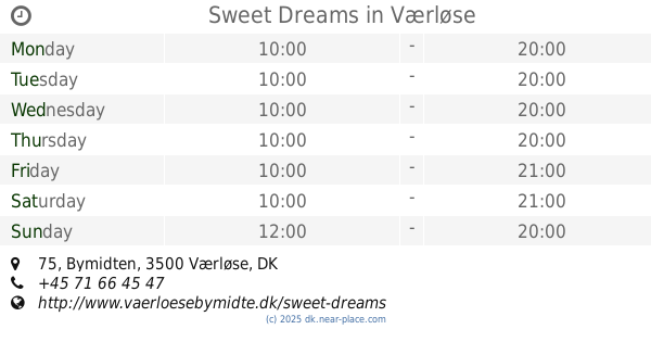
Sweet Dreams
Bymidten 75, Værløse
Store
read more
2.956 km
Overlevelsesgrej.DK
Hellevangen 32, Måløv
Store
read more
2.989 km
N.K.VVS og Gasteknik v/Niels Karner
Kratvej 61, Måløv
Store
read more
3.03 km
Preben Bech
Ved Gershøj 90, Måløv
Store
read more
3.884 km
ORIGIO
Knardrupvej, Måløv
Store
read more
📑
all categories
Accounting
Administrative area level 1
Administrative area level 2
Airport
Amusement park
Aquarium
Art gallery
Atm
Bakery
Bank
Bar
Beauty salon
Bicycle store
Book store
Bowling alley
Bus station
Cafe
Campground
Car dealer
Car rental
Car repair
Car wash
Casino
Cemetery
Church
City hall
Clothing store
Colloquial area
Convenience store
Country
Courthouse
Dentist
Department store
Doctor
Electrician
Electronics store
Embassy
Finance
Fire station
Florist
Food
Funeral home
Furniture store
Gas station
General contractor
Grocery or supermarket
Gym
Hair care
Hardware store
Health
Hindu Temple
Home goods store
Hospital
Insurance agency
Jewelry store
Laundry
Lawyer
Library
Light rail station
Liquor store
Local government office
Locality
Locksmith
Lodging
Meal delivery
Meal takeaway
Mosque
Movie rental
Movie theater
Moving company
Museum
Natural feature
Neighborhood
Night club
Painter
Park
Parking
Pet store
Pharmacy
Physiotherapist
Place of worship
Plumber
Point of interest
Police
Political
Post office
Premise
Real estate agency
Restaurant
Roofing contractor
Route
Rv park, camping
School
Shoe store
Shopping mall
Spa
Stadium
Storage
Store
Subpremise
Subway station
Supermarket
Synagogue
Taxi stand
Train station
Transit station
Travel agency
University
Veterinary care
Zoo
sublocality level 1
sublocality level 2
↑