Store nearby Minimarked
Coronavirus disease (COVID-19) Situation
confirmed cases
3183756
deaths
8814
Denmark
Store nearby Minimarked
Minimarked
Motalavej 57, Korsør Denmark
contacts phone
:
+45
Latitude:
55.3478027
, Longitude:
11.1345017
read more
nearest Store
554 m
MM Legetøj I/S
Tårnborgvej 95, Korsør
Store
read more
715 m
Anhalt Design v/Marius Peter Liljefeld Anhalt
Tovesvej 45, Korsør
Store
read more
955 m
Slikhjørnet
Halsskovvej 26, Korsør
Store
read more
983 m
Spil og vind
Halsskovvej 17, Korsør
Store
read more
983 m
Play and win
Halsskovvej 17, Korsør
Store
read more
984 m
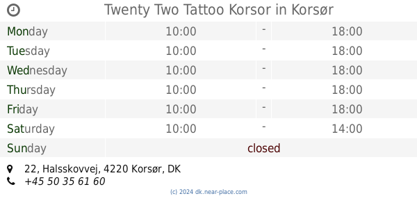
Twenty Two Tattoo Korsor
Halsskovvej 22, Korsør
Store
read more
1.008 km
Krakaus Genbrug og Cafe
Halsskovvej 13, Korsør
Store
read more
1.008 km
Krakaus Recycling and Cafe
Halsskovvej 13, Korsør
Store
read more
1.028 km
Moster K
Halsskovvej 11, Korsør
Store
read more
1.066 km
Mission Afrika Genbrug
Halsskovvej 12, Korsør
Store
read more
1.078 km
Herlighederne.DK v/Gert Jakobsen
Halsskovvej 3, Korsør
Store
read more
1.083 km
Herlighederne.dk Legetøj til store og små
Halsskovvej 3, Korsør
Store
read more
1.235 km
Hanne A Ceramics
Strandvej 32, Korsør
Store
read more
1.235 km
Hanne A Keramik
Strandvej 32, Korsør
Store
read more
1.259 km
CARTNEY Concierge Service
3TH,, Strandvej 29, Korsør
Store
read more
1.588 km
n'lock | Bicycle Lock
Lilleøvej 19, Korsør
Store
read more
1.693 km
Pro-Safe A/S
Møllevangen 60, Korsør
Store
read more
1.905 km
Kirkens Korshær
Brogade 5A, Korsør
Store
read more
1.916 km
Korsør MadMarked
Kirkepladsen 10, Korsør
Store
read more
1.916 km
Korsør Madmarked ApS
Kirkepladsen 10, Korsør
Store
read more
1.935 km
Høreklinikken Korsør
Kirkepladsen 4, st, Korsør
Store
read more
1.983 km
Johnsen Optik
Algade 56, Korsør
Store
read more
1.996 km
Red Cross Op Shop
Torvet 2, Korsør
Store
read more
1.996 km
Røde Kors genbrugsbutik - Korsør
Torvet 2, Korsør
Store
read more
2.022 km
Wilderness Outdoor
Caspar Brands Plads 1, Korsør
Store
read more
📑
all categories
Accounting
Administrative area level 1
Administrative area level 2
Airport
Amusement park
Aquarium
Art gallery
Atm
Bakery
Bank
Bar
Beauty salon
Bicycle store
Book store
Bowling alley
Bus station
Cafe
Campground
Car dealer
Car rental
Car repair
Car wash
Casino
Cemetery
Church
City hall
Clothing store
Colloquial area
Convenience store
Country
Courthouse
Dentist
Department store
Doctor
Electrician
Electronics store
Embassy
Finance
Fire station
Florist
Food
Funeral home
Furniture store
Gas station
General contractor
Grocery or supermarket
Gym
Hair care
Hardware store
Health
Hindu Temple
Home goods store
Hospital
Insurance agency
Jewelry store
Laundry
Lawyer
Library
Light rail station
Liquor store
Local government office
Locality
Locksmith
Lodging
Meal delivery
Meal takeaway
Mosque
Movie rental
Movie theater
Moving company
Museum
Natural feature
Neighborhood
Night club
Painter
Park
Parking
Pet store
Pharmacy
Physiotherapist
Place of worship
Plumber
Point of interest
Police
Political
Post office
Premise
Real estate agency
Restaurant
Roofing contractor
Route
Rv park, camping
School
Shoe store
Shopping mall
Spa
Stadium
Storage
Store
Subpremise
Subway station
Supermarket
Synagogue
Taxi stand
Train station
Transit station
Travel agency
University
Veterinary care
Zoo
sublocality level 1
sublocality level 2
↑