Store nearby føtex
Coronavirus disease (COVID-19) Situation
confirmed cases
3183756
deaths
8814
Denmark
Store nearby føtex
føtex
10, Klosterparks Alle, 4100, Ringsted, DK Danmark
contacts phone
:
+45 57 68 50 00
website:
www.føtex.dk
Latitude:
55.4537003
, Longitude:
11.788095
larger map & directions
read more
nearest Store
11 m
Tvins
Klosterparks Alle 10, Ringsted
Store
read more
21 m
Thiele Glasses & Contact Lenses
Klosterparks Alle 10, Ringsted
Store
read more
21 m
Obi Sport Outlet (804)
Klosterparks Alle 10, Ringsted
Store
read more
47 m
Buddy Legetøj
Klosterparks Alle 10, Ringsted
Store
read more
49 m
Deko by Lind
Ringstedvej, Ringsted
Store
read more
78 m
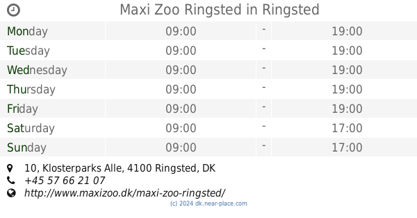
Maxi Zoo Ringsted
Klosterparks Alle 10, Ringsted
Store
read more
137 m
Sport Outlet
Ringstedvej, Ringsted
Store
read more
214 m
Samsonite
Klosterparks Alle 1, Ringsted
Store
read more
283 m
The Body Shop Ringsted
Klosterparks Alle 3, Ringsted
Store
read more
295 m
Villeroy & Boch
Kloster Center 8, Ringsted
Store
read more
377 m
Tattoos By Larsen
Nørretorv 22, Ringsted
Store
read more
519 m
Ringsted Monumentforretning
Bøllingsvej 51, Ringsted
Store
read more
654 m
Ringsted hobbycenter
Nørregade 29, Ringsted
Store
read more
710 m
Galaksi Cut & Trim
Nørregade 16, Ringsted
Store
read more
710 m
Galaksi Klip & Trim
Nørregade 16, Ringsted
Store
read more
710 m
BR-Legetøj
Nørregade 16, Ringsted
Store
read more
714 m
Benløse Spillehal
Fredensvej 7A, Ringsted
Store
read more
726 m
De Fries Sportsudstyr
Pilevangen 40, Ringsted
Store
read more
786 m
Flying Tiger Copenhagen
Nørregade 8, Ringsted
Store
read more
813 m
SuperPris
Nørregade 7, Ringsted
Store
read more
889 m
Kirkens Korshær Ringsted
Sct Knudsgade 3, Ringsted
Store
read more
979 m
Mission Afrika Genbrug
Benløseparken 2, Ringsted
Store
read more
983 m
Normal Ringsted
Torvet 1, Ringsted
Store
read more
1.108 km
Helseklubben.DK v/Timo Jensen
Anlægsvej 10, Ringsted
Store
read more
1.163 km
Benløse Slagteren
4100, Roskildevej 182, Ringsted
Store
read more
📑
all categories
Accounting
Administrative area level 1
Administrative area level 2
Airport
Amusement park
Aquarium
Art gallery
Atm
Bakery
Bank
Bar
Beauty salon
Bicycle store
Book store
Bowling alley
Bus station
Cafe
Campground
Car dealer
Car rental
Car repair
Car wash
Casino
Cemetery
Church
City hall
Clothing store
Colloquial area
Convenience store
Country
Courthouse
Dentist
Department store
Doctor
Electrician
Electronics store
Embassy
Finance
Fire station
Florist
Food
Funeral home
Furniture store
Gas station
General contractor
Grocery or supermarket
Gym
Hair care
Hardware store
Health
Hindu Temple
Home goods store
Hospital
Insurance agency
Jewelry store
Laundry
Lawyer
Library
Light rail station
Liquor store
Local government office
Locality
Locksmith
Lodging
Meal delivery
Meal takeaway
Mosque
Movie rental
Movie theater
Moving company
Museum
Natural feature
Neighborhood
Night club
Painter
Park
Parking
Pet store
Pharmacy
Physiotherapist
Place of worship
Plumber
Point of interest
Police
Political
Post office
Premise
Real estate agency
Restaurant
Roofing contractor
Route
Rv park, camping
School
Shoe store
Shopping mall
Spa
Stadium
Storage
Store
Subpremise
Subway station
Supermarket
Synagogue
Taxi stand
Train station
Transit station
Travel agency
University
Veterinary care
Zoo
sublocality level 1
sublocality level 2
↑