Store nearby FOAMGLAS
Coronavirus disease (COVID-19) Situation
confirmed cases
3183756
deaths
8814
Denmark
Store nearby FOAMGLAS
FOAMGLAS
Vejlby Vænge 115, Risskov Dinamarca
contacts phone
:
+45
Latitude:
56.2018144
, Longitude:
10.2151675
read more
nearest Store
256 m
IC-Result
8240, Vejlby Toften, Risskov
Store
read more
518 m
DALIAs Systue
Stenagervej 2, Risskov
Store
read more
518 m
DALIAs Systue & Skrædderi
Stenagervej 2, Risskov
Store
read more
770 m
Flexminds ApS
Sindalsvej 7, Risskov
Store
read more
775 m
D-top A/S
Nordlandsvej 90, Risskov
Store
read more
829 m
Anatomic SITT
Viengevej 4, Risskov
Store
read more
854 m
Frede Andersen VVS A / S
Sindalsvej 15, Risskov
Store
read more
854 m
Frede Andersen VVS A/S
Sindalsvej 15, Risskov
Store
read more
884 m
Mach01.com
Sindalsvej 42, Risskov
Store
read more
884 m
Keramiker Lene Eva Beier Heidmann
Dybbølvej 27, Risskov
Store
read more
885 m
MAULUND A/S
Sindalsvej 3, Risskov
Store
read more
885 m
MAULUND ApS
Sindalsvej 3, Risskov
Store
read more
885 m
MOBILCOVERS.DK
Sindalsvej 3, Risskov
Store
read more
903 m
TABLETCOVERS.DK
Sindalsvej 3, Risskov
Store
read more
919 m
Simply Tea Ltd.
Norddigesvej 4 st. tv., 8240, Risskov
Store
read more
919 m
Simply Tea ApS
Norddigesvej 4 st. tv., 8240, Risskov
Store
read more
930 m
LinusPro
Norddigesvej 2, Risskov
Store
read more
988 m
Bygma Risskov
Sindalsvej 4, Risskov
Store
read more
1.047 km
Gastech-Energi A/S
Sindalsvej 8, Risskov
Store
read more
1.078 km
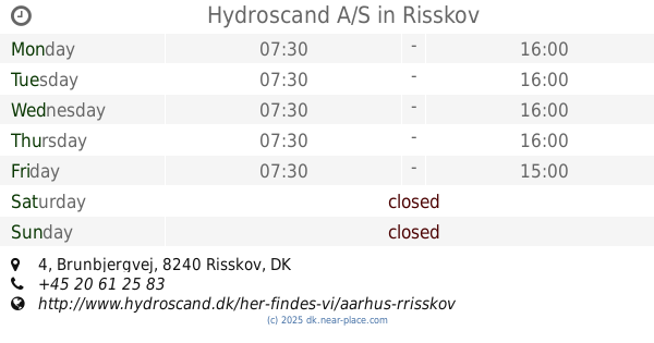
Hydroscand A/S
Brunbjergvej 4, Risskov
Store
read more
1.167 km
Dansk Marine Center A/S
Stokagervej 23, Risskov
Store
read more
1.167 km
Danish Marine Center A / S
Stokagervej 23, Risskov
Store
read more
1.287 km
Næringen Genbrug
Næringen 52, Risskov
Store
read more
1.306 km
Næringen lokal kiosk
Næringen, Risskov
Store
read more
1.453 km
Ostejyden
Frijsenborgvej 5, Risskov
Store
read more
📑
all categories
Accounting
Administrative area level 1
Administrative area level 2
Airport
Amusement park
Aquarium
Art gallery
Atm
Bakery
Bank
Bar
Beauty salon
Bicycle store
Book store
Bowling alley
Bus station
Cafe
Campground
Car dealer
Car rental
Car repair
Car wash
Casino
Cemetery
Church
City hall
Clothing store
Colloquial area
Convenience store
Country
Courthouse
Dentist
Department store
Doctor
Electrician
Electronics store
Embassy
Finance
Fire station
Florist
Food
Funeral home
Furniture store
Gas station
General contractor
Grocery or supermarket
Gym
Hair care
Hardware store
Health
Hindu Temple
Home goods store
Hospital
Insurance agency
Jewelry store
Laundry
Lawyer
Library
Light rail station
Liquor store
Local government office
Locality
Locksmith
Lodging
Meal delivery
Meal takeaway
Mosque
Movie rental
Movie theater
Moving company
Museum
Natural feature
Neighborhood
Night club
Painter
Park
Parking
Pet store
Pharmacy
Physiotherapist
Place of worship
Plumber
Point of interest
Police
Political
Post office
Premise
Real estate agency
Restaurant
Roofing contractor
Route
Rv park, camping
School
Shoe store
Shopping mall
Spa
Stadium
Storage
Store
Subpremise
Subway station
Supermarket
Synagogue
Taxi stand
Train station
Transit station
Travel agency
University
Veterinary care
Zoo
sublocality level 1
sublocality level 2
↑