Restaurant nearby Ferdinands Bøfhus ApS
Coronavirus disease (COVID-19) Situation
confirmed cases
3183756
deaths
8814
Denmark
Restaurant nearby Ferdinands Bøfhus ApS
Ferdinands Bøfhus ApS
Nørregade 31, Ringsted Dania
contacts phone
:
+45
Latitude:
55.4478749
, Longitude:
11.7888196
read more
nearest Restaurant
23 m
Kebab Huset
Nørregade 22, Ringsted
Restaurant
read more
85 m
KOKKEN OG TYREN
Nørregade 38, Ringsted
Restaurant
read more
85 m
Kokken & Tyren
Nørregade 38, Ringsted
Restaurant
read more
109 m
Dhaba Ringsted
Nørregade 13, Ringsted
Restaurant
read more
121 m
Fresh4you
Nørregade 47, Ringsted
Restaurant
read more
138 m
Minigrillen
Nørregade 6, Ringsted
Restaurant
read more
224 m
Raadhuskroen
Sct. Bendtsgade 8, Ringsted
Restaurant
read more
229 m
Western Sushi
Sct. Bendtsgade 10, Ringsted
Restaurant
read more
230 m
[M]eatery Ringsted
Sct Knudsgade 1, Ringsted
Restaurant
read more
338 m
Italy & Italy Ristorante
Torvet 1C, Ringsted
Restaurant
read more
395 m
Oishii
Tinggade 1, Ringsted
Restaurant
read more
483 m
The Burger
Klosterparks Alle 30, Ringsted
Restaurant
read more
519 m
Odd Fellow Logen Asger Ryg
Teglovnsvej 44, Ringsted
Restaurant
read more
575 m
Burger King
Klosterparks Alle 6, Ringsted
Restaurant
read more
584 m
LA RUSTICA - RINGSTED
Klosterparks Alle 11, Ringsted
Restaurant
read more
586 m
La Rustica, café & restaurant
Klosterparks Alle 10, Ringsted
Restaurant
read more
607 m
Café Aspendos
Møllegade 11, Ringsted
Restaurant
read more
629 m
Fashion Outlet
Klosterparks Alle 10, Ringsted
Restaurant
read more
657 m
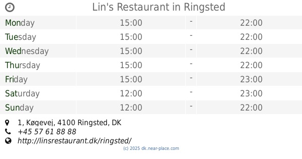
Lin's Restaurant
Køgevej 1, Ringsted
Restaurant
read more
735 m
Café Olympus
Tværalle 8, Ringsted
Restaurant
read more
875 m
Selskabslokalerne ApS
Dronningensgade 30, Ringsted
Restaurant
read more
893 m
Hua Yang
Køgevej 24, Ringsted
Restaurant
read more
984 m
El Castillos
Vestervej 2, Ringsted
Restaurant
read more
994 m
Quick Kebab
Vestervej 2, Ringsted
Restaurant
read more
1.004 km
El Castillo's Cantina
Vestervej 2, Ringsted
Restaurant
read more
📑
all categories
Accounting
Administrative area level 1
Administrative area level 2
Airport
Amusement park
Aquarium
Art gallery
Atm
Bakery
Bank
Bar
Beauty salon
Bicycle store
Book store
Bowling alley
Bus station
Cafe
Campground
Car dealer
Car rental
Car repair
Car wash
Casino
Cemetery
Church
City hall
Clothing store
Colloquial area
Convenience store
Country
Courthouse
Dentist
Department store
Doctor
Electrician
Electronics store
Embassy
Finance
Fire station
Florist
Food
Funeral home
Furniture store
Gas station
General contractor
Grocery or supermarket
Gym
Hair care
Hardware store
Health
Hindu Temple
Home goods store
Hospital
Insurance agency
Jewelry store
Laundry
Lawyer
Library
Light rail station
Liquor store
Local government office
Locality
Locksmith
Lodging
Meal delivery
Meal takeaway
Mosque
Movie rental
Movie theater
Moving company
Museum
Natural feature
Neighborhood
Night club
Painter
Park
Parking
Pet store
Pharmacy
Physiotherapist
Place of worship
Plumber
Point of interest
Police
Political
Post office
Premise
Real estate agency
Restaurant
Roofing contractor
Route
Rv park, camping
School
Shoe store
Shopping mall
Spa
Stadium
Storage
Store
Subpremise
Subway station
Supermarket
Synagogue
Taxi stand
Train station
Transit station
Travel agency
University
Veterinary care
Zoo
sublocality level 1
sublocality level 2
↑