Restaurant nearby Fasanen Pizza
Coronavirus disease (COVID-19) Situation
confirmed cases
3183756
deaths
8814
Denmark
Restaurant nearby Fasanen Pizza
Fasanen Pizza
Fasanvej 1, Køge Dinamarca
contacts phone
:
+45
Latitude:
55.4365612
, Longitude:
12.1601231
read more
nearest Restaurant
152 m
Kulturhuset Cafeen
Langelandsvej 32, Køge
Restaurant
read more
673 m
Elverhøi
Vordingborgvej 51, Køge
Restaurant
read more
1.285 km
Marios Pizza Bar & Grill
Marksvinget 21, Køge
Restaurant
read more
1.316 km
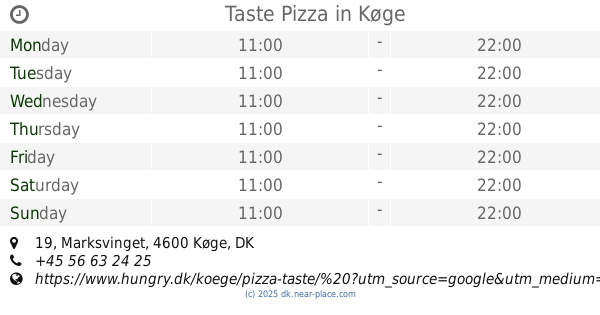
Taste Pizza
Marksvinget 19, Køge
Restaurant
read more
2.354 km
Restaurant Quintus
Toldbodvej 20, Køge
Restaurant
read more
2.447 km
Da Pino V/necmettin Inanc
Vordingborgvej 92, Herfølge
Restaurant
read more
2.524 km
Tapperiet
Søndre Badevej 1, Køge
Restaurant
read more
2.542 km
Café Hammershus
Brogade 7, Køge
Restaurant
read more
2.556 km
Slagter Stig & Co.
Carlsensvej 8, Køge
Restaurant
read more
2.557 km
Cafe Sapore
Køge
Restaurant
read more
2.585 km
Lucky Sushi
Carlsensvej 8, Køge
Restaurant
read more
2.587 km
Pappa's Juice & Sandwich
Vestergade 18, Køge
Restaurant
read more
2.607 km
Restaurant Azuma
Vestergade 30, Køge
Restaurant
read more
2.624 km
Det Sunde Køkken
Torvet 20B, Køge
Restaurant
read more
2.63 km
Restaurant Zhou
Vestergade 20, Køge
Restaurant
read more
2.689 km
Jenners Dockside
Havnen 21, Køge
Restaurant
read more
2.696 km
Chiang Mai Thai Cuisine Restaurant & Take Away
Havnen 23 b, Køge
Restaurant
read more
2.699 km
Restaurant Skipperkroen
Havnen 25, Køge
Restaurant
read more
2.707 km
Havnebistroen v/Mahmut Karabacak
Havnen 23B, Køge
Restaurant
read more
2.757 km
Café Liyana
Nørregade 9, Køge
Restaurant
read more
2.793 km
Odd Fellowgaarden
Jernbanegade 10, Køge
Restaurant
read more
2.839 km
Xpress Kebab
Stationspladsen 3, Køge
Restaurant
read more
2.839 km
Xpress Kebab I/S
Stationspladsen 3, Køge
Restaurant
read more
2.905 km
Shawarma Hus
Nørregade 33, Køge
Restaurant
read more
3.197 km
King of French Chicken v/Eyup Turan
Nørre Boulevard 55, Køge
Restaurant
read more
📑
all categories
Accounting
Administrative area level 1
Administrative area level 2
Airport
Amusement park
Aquarium
Art gallery
Atm
Bakery
Bank
Bar
Beauty salon
Bicycle store
Book store
Bowling alley
Bus station
Cafe
Campground
Car dealer
Car rental
Car repair
Car wash
Casino
Cemetery
Church
City hall
Clothing store
Colloquial area
Convenience store
Country
Courthouse
Dentist
Department store
Doctor
Electrician
Electronics store
Embassy
Finance
Fire station
Florist
Food
Funeral home
Furniture store
Gas station
General contractor
Grocery or supermarket
Gym
Hair care
Hardware store
Health
Hindu Temple
Home goods store
Hospital
Insurance agency
Jewelry store
Laundry
Lawyer
Library
Light rail station
Liquor store
Local government office
Locality
Locksmith
Lodging
Meal delivery
Meal takeaway
Mosque
Movie rental
Movie theater
Moving company
Museum
Natural feature
Neighborhood
Night club
Painter
Park
Parking
Pet store
Pharmacy
Physiotherapist
Place of worship
Plumber
Point of interest
Police
Political
Post office
Premise
Real estate agency
Restaurant
Roofing contractor
Route
Rv park, camping
School
Shoe store
Shopping mall
Spa
Stadium
Storage
Store
Subpremise
Subway station
Supermarket
Synagogue
Taxi stand
Train station
Transit station
Travel agency
University
Veterinary care
Zoo
sublocality level 1
sublocality level 2
↑