Park nearby The Rose Garden
Coronavirus disease (COVID-19) Situation
confirmed cases
3183756
deaths
8814
Denmark
Park nearby The Rose Garden
The Rose Garden
Hammelstrupvej 41, København SV Denmark
contacts phone
:
+45
Latitude:
55.6403021
, Longitude:
12.517569
read more
nearest Park
174 m
Valby Disc Golf Tee 1
Hammelstrupvej 98, København SV
Park
read more
271 m
Gryden - festivalpladsen
2450, København
Park
read more
558 m
Rollespil
Hammelstrupvej 75, København SV
Park
read more
601 m
Valby Park
Hammelstrupvej 98, København SV
Park
read more
989 m
Bjerget
Sdr Kystagervej 4, Hvidovre
Park
read more
1.104 km
Kystagerparken
Sdr Kystagervej 10, Hvidovre
Park
read more
1.139 km
Sydhavnstippen
Fragtvej 9, København SV
Park
read more
1.728 km
Hvidovre Strandpark
Hvidovre
Park
read more
1.737 km
Havemands Assistance
Bjeverskov Alle 62, Hvidovre
Park
read more
1.778 km
Lodsparken
Lodsvej 80, Hvidovre
Park
read more
1.8 km
Grønttorvsparken
Grønttorvet 30, Valby
Park
read more
1.815 km
Hvidovrestrand
Kalveboderne
Park
read more
2.305 km
Secret Garden
Strandvangsvej 47, Hvidovre
Park
read more
2.511 km
Mindesten - Brandstifteren Jens Nielsen
I G Smiths Alle 22, Hvidovre
Park
read more
2.594 km
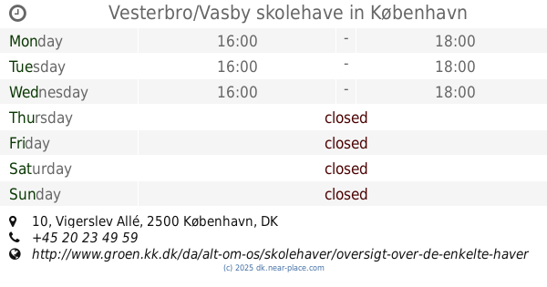
Vesterbro/Vasby skolehave
Vigerslev Allé 10, Valby
Park
read more
2.624 km
Have 160, sti 18 H/F Sønderbro
Hf. Sønderbro, København S
Park
read more
2.624 km
Garden 160 H / F Sønderbro
Hf. Sønderbro, København S
Park
read more
2.858 km
Hanging Gardens
Bohrsgade, København V
Park
read more
2.956 km
Vesterbros Nabopark
København V
Park
read more
2.963 km
Storbyhaven Gammel Valby
Gadekærvej, Valby
Park
read more
3.234 km
Østen for Humlen
Vesterfælledvej 66, København
Park
read more
3.35 km
Enghave Parken
Enghaveparken, København
Park
read more
3.566 km
HaveBo Anlægsgartner ApS
Vigerslevvej 66, Valby
Park
read more
3.747 km
Hundepark
Rødovre
Park
read more
3.794 km
Cykelslangen
Cykelslangen, København V
Park
read more
📑
all categories
Accounting
Administrative area level 1
Administrative area level 2
Airport
Amusement park
Aquarium
Art gallery
Atm
Bakery
Bank
Bar
Beauty salon
Bicycle store
Book store
Bowling alley
Bus station
Cafe
Campground
Car dealer
Car rental
Car repair
Car wash
Casino
Cemetery
Church
City hall
Clothing store
Colloquial area
Convenience store
Country
Courthouse
Dentist
Department store
Doctor
Electrician
Electronics store
Embassy
Finance
Fire station
Florist
Food
Funeral home
Furniture store
Gas station
General contractor
Grocery or supermarket
Gym
Hair care
Hardware store
Health
Hindu Temple
Home goods store
Hospital
Insurance agency
Jewelry store
Laundry
Lawyer
Library
Light rail station
Liquor store
Local government office
Locality
Locksmith
Lodging
Meal delivery
Meal takeaway
Mosque
Movie rental
Movie theater
Moving company
Museum
Natural feature
Neighborhood
Night club
Painter
Park
Parking
Pet store
Pharmacy
Physiotherapist
Place of worship
Plumber
Point of interest
Police
Political
Post office
Premise
Real estate agency
Restaurant
Roofing contractor
Route
Rv park, camping
School
Shoe store
Shopping mall
Spa
Stadium
Storage
Store
Subpremise
Subway station
Supermarket
Synagogue
Taxi stand
Train station
Transit station
Travel agency
University
Veterinary care
Zoo
sublocality level 1
sublocality level 2
↑