Night club nearby Søren og trolle
Coronavirus disease (COVID-19) Situation
confirmed cases
3183756
deaths
8814
Denmark
Night club nearby Søren og trolle
Søren og trolle
8700, Søndermarksvej 54, Horsens Danmark
contacts phone
:
+45
Latitude:
55.8143723
, Longitude:
9.9215411
read more
nearest Night club
6.649 km
Spirit Club Herning
Mindegade 5, Herning
Night club
read more
6.791 km
Onkels Vandpibe Cafe
Borgergade 3, Horsens
Night club
read more
7.065 km
Jagtbar Horsens
Nørregade 7, Horsens
Night club
read more
7.089 km
Zwei Grosse Bier Bar Horsens A/S
Graven 21, Horsens
Night club
read more
7.22 km
Hemingway's Horsens
Hejmdalsgade 4, Horsens
Night club
read more
7.224 km
Mad Americans
Rædersgade 5, Horsens
Night club
read more
7.224 km
Jin Bar og Natklub
Rædersgade 5, Horsens
Night club
read more
21.853 km
Klosterlundsvej
Ringklostervej 16, Skanderborg
Night club
read more
23.541 km
Camping Skanderborg
Vrold Tværvej 27A, Skanderborg
Night club
read more
23.743 km
Gartnerboligen
Villavej 25, Odder
Night club
read more
26.036 km
H Og M Invest
Skomagervej 1B, Vejle
Night club
read more
26.478 km
NOX Network Ltd.
Friis Hansens Vej 5, Vejle
Night club
read more
26.478 km
NOX Network ApS
Friis Hansens Vej 5, Vejle
Night club
read more
26.828 km
Tartan Pub
Dæmningen 40, Vejle
Night club
read more
26.847 km
temabar APS 23-05
Dæmningen 38, Vejle
Night club
read more
26.976 km
Thorben Pilfinger
Vedelsgade 55C, Vejle
Night club
read more
27.008 km
Lucky's Sports-bar
Borgvold 12C, Vejle
Night club
read more
41.768 km
Crystal Aarhus ApS Under Tvangsopløsning
Telefonsmøgen 6, Aarhus C
Night club
read more
42.083 km
Alberts
Store Torv 3, Aarhus C
Night club
read more
45.711 km
Discoteque Tordenskiold
Akseltorv 2B, Kolding
Night club
read more
52.148 km
Stige Swingerne
Skippervej 56, Odense
Night club
read more
53.327 km
The Worlds End
Windelsvej 8, Odense C
Night club
read more
54.276 km
Slagteriet Natklub & Eventhus
Rugårdsvej 5, Odense C
Night club
read more
54.877 km
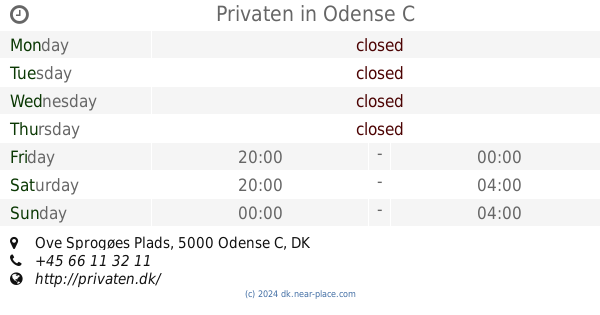
Privaten
Ove Sprogøes Plads, Odense C
Night club
read more
62.053 km
Crazy Daisy Vejen
Søndergade 10, Vejen
Night club
read more
📑
all categories
Accounting
Administrative area level 1
Administrative area level 2
Airport
Amusement park
Aquarium
Art gallery
Atm
Bakery
Bank
Bar
Beauty salon
Bicycle store
Book store
Bowling alley
Bus station
Cafe
Campground
Car dealer
Car rental
Car repair
Car wash
Casino
Cemetery
Church
City hall
Clothing store
Colloquial area
Convenience store
Country
Courthouse
Dentist
Department store
Doctor
Electrician
Electronics store
Embassy
Finance
Fire station
Florist
Food
Funeral home
Furniture store
Gas station
General contractor
Grocery or supermarket
Gym
Hair care
Hardware store
Health
Hindu Temple
Home goods store
Hospital
Insurance agency
Jewelry store
Laundry
Lawyer
Library
Light rail station
Liquor store
Local government office
Locality
Locksmith
Lodging
Meal delivery
Meal takeaway
Mosque
Movie rental
Movie theater
Moving company
Museum
Natural feature
Neighborhood
Night club
Painter
Park
Parking
Pet store
Pharmacy
Physiotherapist
Place of worship
Plumber
Point of interest
Police
Political
Post office
Premise
Real estate agency
Restaurant
Roofing contractor
Route
Rv park, camping
School
Shoe store
Shopping mall
Spa
Stadium
Storage
Store
Subpremise
Subway station
Supermarket
Synagogue
Taxi stand
Train station
Transit station
Travel agency
University
Veterinary care
Zoo
sublocality level 1
sublocality level 2
↑