Night club nearby KJ's bodel
Coronavirus disease (COVID-19) Situation
confirmed cases
3183756
deaths
8814
Denmark
Night club nearby KJ's bodel
KJ's bodel
Torvet 4, Nyborg Dania
contacts phone
:
+45
Latitude:
55.3130478
, Longitude:
10.7902095
read more
nearest Night club
214 m
Borgerforeningens Hus
Nørrevoldgade, Nyborg
Night club
read more
22.115 km
Pcads
Algade 26, Korsør
Night club
read more
22.249 km
Dance Odense, Funen Square Dance Club
Hjulets Kvarter 119, Odense SØ
Night club
read more
22.249 km
Dans Odense: Fyn Square Dance Club
Hjulets Kvarter 119, Odense SØ
Night club
read more
26.05 km
DevilsDen
Odense
Night club
read more
26.079 km
Devil'sDenmark
Kræmmermarken, Havek, Odense C
Night club
read more
26.733 km
Benny's blowj0bs
Ryttergade 8-4, Odense
Night club
read more
26.772 km
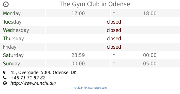
The Gym Club
Overgade 45, Odense C
Night club
read more
26.772 km
Nunchi
Overgade 45, Odense C
Night club
read more
27.062 km
Boogie Dance Café
Nørregade 21, Odense C
Night club
read more
27.066 km
AYA Club
Klingenberg 14, Odense C
Night club
read more
27.124 km
Color Bar
Mageløs 1, Odense C
Night club
read more
27.164 km
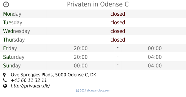
Privaten
Ove Sprogøes Plads, Odense C
Night club
read more
27.166 km
Dansebar Odense
Jernbanegade 3, Odense C
Night club
read more
27.172 km
Privaten
Jernbanegade 3, 1 sal, Odense
Night club
read more
27.279 km
Stige Swingerne
Skippervej 56, Odense
Night club
read more
27.675 km
The Worlds End
Windelsvej 8, Odense C
Night club
read more
27.839 km
Slagteriet Natklub & Eventhus
Rugårdsvej 5, Odense C
Night club
read more
30.31 km
Harmoni
Møllergade 27, Svendborg
Night club
read more
30.364 km
Loca Daisy
Frederiksgade 6, Svendborg
Night club
read more
30.364 km
Crazy Daisy
Frederiksgade 6, Svendborg
Night club
read more
30.43 km
The Blue Farm
Frederiksgade 11F, Svendborg
Night club
read more
37.026 km
Nattoget
Gamle Torv 8, Slagelse
Night club
read more
37.07 km
Gammeltorv
Gamle Torv 2, Slagelse
Night club
read more
37.176 km
Jazzmin Swing Band
Klostergade 41, Slagelse
Night club
read more
📑
all categories
Accounting
Administrative area level 1
Administrative area level 2
Airport
Amusement park
Aquarium
Art gallery
Atm
Bakery
Bank
Bar
Beauty salon
Bicycle store
Book store
Bowling alley
Bus station
Cafe
Campground
Car dealer
Car rental
Car repair
Car wash
Casino
Cemetery
Church
City hall
Clothing store
Colloquial area
Convenience store
Country
Courthouse
Dentist
Department store
Doctor
Electrician
Electronics store
Embassy
Finance
Fire station
Florist
Food
Funeral home
Furniture store
Gas station
General contractor
Grocery or supermarket
Gym
Hair care
Hardware store
Health
Hindu Temple
Home goods store
Hospital
Insurance agency
Jewelry store
Laundry
Lawyer
Library
Light rail station
Liquor store
Local government office
Locality
Locksmith
Lodging
Meal delivery
Meal takeaway
Mosque
Movie rental
Movie theater
Moving company
Museum
Natural feature
Neighborhood
Night club
Painter
Park
Parking
Pet store
Pharmacy
Physiotherapist
Place of worship
Plumber
Point of interest
Police
Political
Post office
Premise
Real estate agency
Restaurant
Roofing contractor
Route
Rv park, camping
School
Shoe store
Shopping mall
Spa
Stadium
Storage
Store
Subpremise
Subway station
Supermarket
Synagogue
Taxi stand
Train station
Transit station
Travel agency
University
Veterinary care
Zoo
sublocality level 1
sublocality level 2
↑