Gas station nearby Uno-X Automat
Denmark
Gas station nearby Uno-X Automat
Uno-X Automat
Loftbrovej, Nørresundby Danmark
contacts phone
:
+45
Latitude:
57.0891449
, Longitude:
9.9714446
read more
nearest Gas station
2 m
Uno-X
Loftbrovej 2, Nørresundby
Gas station
read more
316 m
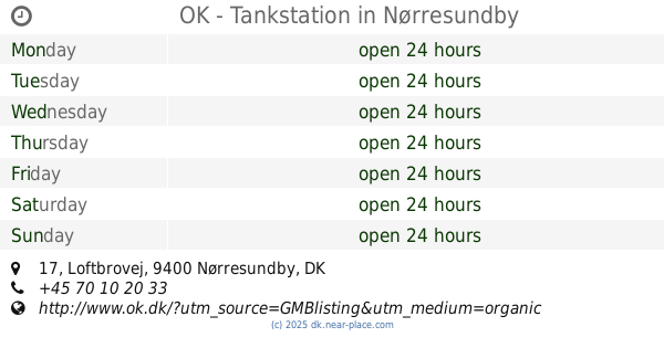
OK - Tankstation
Loftbrovej 17, Nørresundby
Gas station
read more
2.633 km
OK - Tankstation
Forbindelsesvejen 148, Nørresundby
Gas station
read more
2.797 km
INGO Nørresundby Hjørringvej
Hjørringvej 52-54, Nørresundby
Gas station
read more
2.924 km
F24 Tankstation
Hjørringvej 59, Nørresundby
Gas station
read more
3.19 km
Statoil A/S
Rørdalsvej 38, Aalborg Øst
Gas station
read more
3.356 km
Circle K Nørresundby
Løvbakken 2, Nørresundby
Gas station
read more
3.482 km
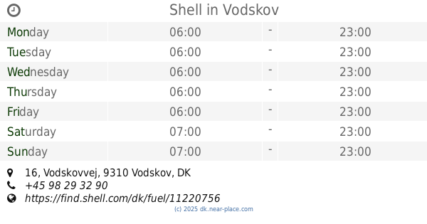
Shell
Vodskovvej 16, Vodskov
Gas station
read more
3.82 km
Shell
Olievej 7, Aalborg Øst
Gas station
read more
3.82 km
Shell
Olievej 7, Aalborg
Gas station
read more
4.031 km
Ingo
Østergade 41, Nørresundby
Gas station
read more
4.257 km
Shell/7-Eleven Nørresundby
Østergade 27-29
Gas station
read more
4.257 km
Shell
Nørresundby, Østergade 27-29
Gas station
read more
4.257 km
Shell
Østergade 27-29
Gas station
read more
4.684 km
OIL! tank & go
Thistedvej 1A, Nørresundby
Gas station
read more
4.684 km
Haarh Benzin Thistedvej 1 B
Thistedvej 1, Nørresundby
Gas station
read more
4.832 km
INGO
Thistedvej 60, Nørresundby
Gas station
read more
4.982 km
Uno-X
Thistedvej 103, Nørresundby
Gas station
read more
5.111 km
Shell
Østerbro 75, Aalborg
Gas station
read more
5.502 km
OK benzin, Vestbyen Aalborg
Dannebrogsgade 64, Aalborg
Gas station
read more
5.503 km
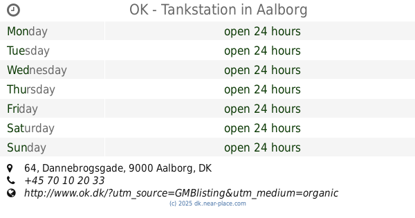
OK - Tankstation
Dannebrogsgade 64, Aalborg
Gas station
read more
5.504 km
Kvickly Vestbyen
Dannebrogsgade 63, Aalborg
Gas station
read more
6.176 km
Shell
Engtoftevej 41, Aalborg
Gas station
read more
6.183 km
Tj Retail ApS
Engtoftevej 41, Aalborg
Gas station
read more
6.432 km
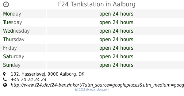
F24 Tankstation
Hasserisvej 102, Aalborg
Gas station
read more
📑
all categories
Accounting
Administrative area level 1
Administrative area level 2
Airport
Amusement park
Aquarium
Art gallery
Atm
Bakery
Bank
Bar
Beauty salon
Bicycle store
Book store
Bowling alley
Bus station
Cafe
Campground
Car dealer
Car rental
Car repair
Car wash
Casino
Cemetery
Church
City hall
Clothing store
Colloquial area
Convenience store
Country
Courthouse
Dentist
Department store
Doctor
Electrician
Electronics store
Embassy
Finance
Fire station
Florist
Food
Funeral home
Furniture store
Gas station
General contractor
Grocery or supermarket
Gym
Hair care
Hardware store
Health
Hindu Temple
Home goods store
Hospital
Insurance agency
Jewelry store
Laundry
Lawyer
Library
Light rail station
Liquor store
Local government office
Locality
Locksmith
Lodging
Meal delivery
Meal takeaway
Mosque
Movie rental
Movie theater
Moving company
Museum
Natural feature
Neighborhood
Night club
Painter
Park
Parking
Pet store
Pharmacy
Physiotherapist
Place of worship
Plumber
Point of interest
Police
Political
Post office
Premise
Real estate agency
Restaurant
Roofing contractor
Route
Rv park, camping
School
Shoe store
Shopping mall
Spa
Stadium
Storage
Store
Subpremise
Subway station
Supermarket
Synagogue
Taxi stand
Train station
Transit station
Travel agency
University
Veterinary care
Zoo
sublocality level 1
sublocality level 2
↑