Gas station nearby Shell
Denmark
Gas station nearby Shell
Shell
Ørbækvej 87, Odense SØ Dania
contacts phone
:
+45
Latitude:
55.38224
, Longitude:
10.430827
read more
nearest Gas station
477 m
OK - Tankstation
Ballerumvej 113, Thisted
Gas station
read more
479 m
OK - Tankstation
Ørbækvej 75, Odense SØ
Gas station
read more
503 m
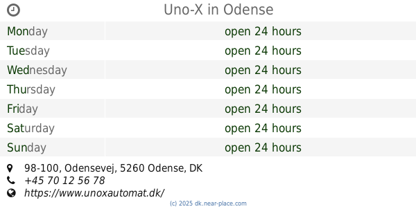
Uno-X
Ørbækvej 60, Odense SØ
Gas station
read more
651 m
METAX station
Niels Bohrs Alle 148,, Odense M
Gas station
read more
653 m
Shell Express
Niels Bohrs Alle 148, Odense M
Gas station
read more
653 m
Shell
Niels Bohrs Alle 148, Odense M
Gas station
read more
1.249 km
Shell Express
248, Nyborgvej 240, Odense SØ
Gas station
read more
1.249 km
Shell
Nyborgvej 240-248, Vildrosevej, Odense
Gas station
read more
1.249 km
Shell Express
Nyborgvej 240-248, Vildrosevej, Odense
Gas station
read more
1.503 km
Odense M Munkerisvej
Munkerisvej 50, Odense M
Gas station
read more
1.505 km
Uno-X
Munkerisvej 50, Odense M
Gas station
read more
1.614 km
Circle K Nyborgvej
Nyborgvej 121, Odense C
Gas station
read more
1.614 km
Circle K Nyborgvej
Nyborgvej 121, Odense
Gas station
read more
1.882 km
OK - Tankstation
Nyborgvej 100, Odense C
Gas station
read more
2.25 km
Q8 Tankstation
Hjallesevej 135, Odense
Gas station
read more
2.369 km
Circlek Hjallesevej
Hjallesevej 25, Odense Municipality, Odense C
Gas station
read more
2.369 km
Circle K
Odense C
Gas station
read more
2.373 km
Circle K
Hjallesevej 25, Odense C
Gas station
read more
2.487 km
Shell
Hjallesevej 240B, Odense
Gas station
read more
2.675 km
Harpsøe ApS
Valmuemarken 4, Odense S
Gas station
read more
2.761 km
Hydro Texaco Odense S
Odensevej 98-100,, Odense S
Gas station
read more
2.762 km
Uno-X
Odensevej 98-100, Odense S
Gas station
read more
3.367 km
Circle K Hjallese
Svendborgvej 1, Odense
Gas station
read more
3.789 km
OK - Tankstation
Odensevej 10, Dalum, Odense
Gas station
read more
3.902 km
INGO Odense, Buchwaldsgade
Buchwaldsgade 2B, Odense C
Gas station
read more
📑
all categories
Accounting
Administrative area level 1
Administrative area level 2
Airport
Amusement park
Aquarium
Art gallery
Atm
Bakery
Bank
Bar
Beauty salon
Bicycle store
Book store
Bowling alley
Bus station
Cafe
Campground
Car dealer
Car rental
Car repair
Car wash
Casino
Cemetery
Church
City hall
Clothing store
Colloquial area
Convenience store
Country
Courthouse
Dentist
Department store
Doctor
Electrician
Electronics store
Embassy
Finance
Fire station
Florist
Food
Funeral home
Furniture store
Gas station
General contractor
Grocery or supermarket
Gym
Hair care
Hardware store
Health
Hindu Temple
Home goods store
Hospital
Insurance agency
Jewelry store
Laundry
Lawyer
Library
Light rail station
Liquor store
Local government office
Locality
Locksmith
Lodging
Meal delivery
Meal takeaway
Mosque
Movie rental
Movie theater
Moving company
Museum
Natural feature
Neighborhood
Night club
Painter
Park
Parking
Pet store
Pharmacy
Physiotherapist
Place of worship
Plumber
Point of interest
Police
Political
Post office
Premise
Real estate agency
Restaurant
Roofing contractor
Route
Rv park, camping
School
Shoe store
Shopping mall
Spa
Stadium
Storage
Store
Subpremise
Subway station
Supermarket
Synagogue
Taxi stand
Train station
Transit station
Travel agency
University
Veterinary care
Zoo
sublocality level 1
sublocality level 2
↑