Gas station nearby Middelfart Assensvej
Coronavirus disease (COVID-19) Situation
confirmed cases
3183756
deaths
8814
Denmark
Gas station nearby Middelfart Assensvej
Middelfart Assensvej
Assensvej 105, Middelfart Danmark
contacts phone
:
+45
Latitude:
55.492835
, Longitude:
9.759694
read more
nearest Gas station
4 m
YX Bonus
Assensvej 105, Middelfart
Gas station
read more
5 m
Uno-X
Assensvej 105, Middelfart
Gas station
read more
12 m
Jakobsen Ingemann
Assensvej 105, Middelfart
Gas station
read more
605 m
OIL! tank & go
Brovejen 4, Middelfart
Gas station
read more
627 m
OIL! tank & go
Brovejen 18, Middelfart
Gas station
read more
793 m
Jytte Svendsen
Hovedvejen 11, Middelfart
Gas station
read more
804 m
Middelfart Hovedvejen
Hovedvejen 11, Middelfart
Gas station
read more
804 m
Uno-X
Hovedvejen 11, Middelfart
Gas station
read more
1.165 km
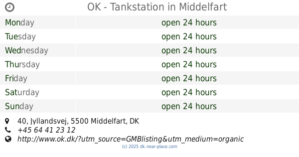
OK - Tankstation
Jyllandsvej 40, Middelfart
Gas station
read more
1.207 km
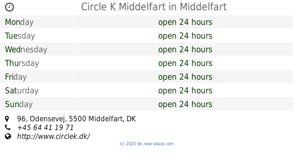
Circle K Middelfart
Odensevej 96, Middelfart
Gas station
read more
1.677 km
Kvickly Middelfart
Østergade 28, Middelfart
Gas station
read more
1.84 km
OK - Tankstation
Østergade 18, Middelfart
Gas station
read more
1.889 km
Shell
17, Stensgårdvej 15, Middelfart
Gas station
read more
1.933 km
F24
Nyvang 1, Middelfart
Gas station
read more
2.146 km
Go'on Middelfart
Skovsvinget 27C, Middelfart
Gas station
read more
2.217 km
Shell Express
Stensgårdvej 13, Middelfart
Gas station
read more
2.217 km
Shell
Stensgårdvej 13, Middelfart
Gas station
read more
2.335 km
INGO
Søndergade 60, Middelfart
Gas station
read more
4.617 km
SuperBrugsen Strib
Sofiendalvej 1, Middelfart
Gas station
read more
5.082 km
OK - Tankstation
Bødkervej 1, Fredericia
Gas station
read more
5.082 km
OK - Tankstation
Bødkervej 1, Snoghøj, Fredericia
Gas station
read more
5.519 km
INGO
Strevelinsvej 1A, Fredericia
Gas station
read more
5.592 km
Circle K Snaremosevej
Snaremosevej 180, Fredericia
Gas station
read more
5.592 km
Circle K Snaremosevej, Fredericia
Snaremosevej 180, Fredericia
Gas station
read more
13.606 km
OK - Tankstation
Søndergade 15, Hadsten
Gas station
read more
📑
all categories
Accounting
Administrative area level 1
Administrative area level 2
Airport
Amusement park
Aquarium
Art gallery
Atm
Bakery
Bank
Bar
Beauty salon
Bicycle store
Book store
Bowling alley
Bus station
Cafe
Campground
Car dealer
Car rental
Car repair
Car wash
Casino
Cemetery
Church
City hall
Clothing store
Colloquial area
Convenience store
Country
Courthouse
Dentist
Department store
Doctor
Electrician
Electronics store
Embassy
Finance
Fire station
Florist
Food
Funeral home
Furniture store
Gas station
General contractor
Grocery or supermarket
Gym
Hair care
Hardware store
Health
Hindu Temple
Home goods store
Hospital
Insurance agency
Jewelry store
Laundry
Lawyer
Library
Light rail station
Liquor store
Local government office
Locality
Locksmith
Lodging
Meal delivery
Meal takeaway
Mosque
Movie rental
Movie theater
Moving company
Museum
Natural feature
Neighborhood
Night club
Painter
Park
Parking
Pet store
Pharmacy
Physiotherapist
Place of worship
Plumber
Point of interest
Police
Political
Post office
Premise
Real estate agency
Restaurant
Roofing contractor
Route
Rv park, camping
School
Shoe store
Shopping mall
Spa
Stadium
Storage
Store
Subpremise
Subway station
Supermarket
Synagogue
Taxi stand
Train station
Transit station
Travel agency
University
Veterinary care
Zoo
sublocality level 1
sublocality level 2
↑