Gas station nearby F24 Tankstation
Coronavirus disease (COVID-19) Situation
confirmed cases
3183756
deaths
8814
Denmark
Gas station nearby F24 Tankstation
F24 Tankstation
Skolekrogen 2, Værløse Dänemark
contacts phone
:
+45
Latitude:
55.77868
, Longitude:
12.3947552
read more
nearest Gas station
1.55 km
Q8 Tankstation
Ballerupvej 20, Værløse
Gas station
read more
1.746 km
Statoil Værløse
Kirke Værløsevej 10, Værløse
Gas station
read more
1.746 km
Shell
10, Kirke Værløsevej, Værløse
Gas station
read more
1.746 km
Statoil Værløse
10, Kirke Værløsevej, Værløse
Gas station
read more
2.727 km
OK - Tankstation
Tibberup Alle 67, Værløse
Gas station
read more
3.094 km
Shell
Ring 4 50, Herlev
Gas station
read more
3.763 km
Circle K Farum
Frederiksborgvej 31, Farum
Gas station
read more
3.763 km
Cirkle K Farum
Frederiksborgvej 31, Farum
Gas station
read more
3.949 km
Q8 Tankstation
Frederiksborgvej 9, Farum
Gas station
read more
4.003 km
Q8 Tankstation
Vadstrupvej 55, Bagsværd
Gas station
read more
4.205 km
Go'on Virum
Frederiksdalsvej 194, Virum
Gas station
read more
4.211 km
Go'on
Østergade 24, Stoholm
Gas station
read more
4.211 km
Dk-benzin
Frederiksdalsvej 194, Virum
Gas station
read more
4.341 km
INGO
Rugmarken 1, Farum
Gas station
read more
4.345 km
METAX station
Rugmarken 1-3,, Farum
Gas station
read more
4.451 km
Circle K Bagsværd
Bagsværd Hovedgade 94, Bagsværd
Gas station
read more
5.127 km
Circle K Herlev
Hjortespringvej 115, Herlev
Gas station
read more
5.142 km
Circle K Danmark A/S
Hjortespringvej 115, Herlev
Gas station
read more
5.153 km
OK Benzin
Hørmarken 10, Farum
Gas station
read more
5.196 km
Tcb Retail ApS
Hold-An Vej 2, Ballerup
Gas station
read more
5.678 km
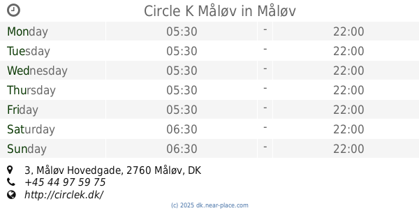
Circle K Måløv
Måløv Hovedgade 3, Måløv
Gas station
read more
6.384 km
Shell Holte
Kongevejen 394, Holte
Gas station
read more
6.384 km
Shell
Kongevejen 394, Holte
Gas station
read more
6.406 km
Q8 Tankstation
Dynamovej 2, Søborg
Gas station
read more
6.423 km
Tankstation fredag kl 7.10
Dynamovej 2, Herlev
Gas station
read more
📑
all categories
Accounting
Administrative area level 1
Administrative area level 2
Airport
Amusement park
Aquarium
Art gallery
Atm
Bakery
Bank
Bar
Beauty salon
Bicycle store
Book store
Bowling alley
Bus station
Cafe
Campground
Car dealer
Car rental
Car repair
Car wash
Casino
Cemetery
Church
City hall
Clothing store
Colloquial area
Convenience store
Country
Courthouse
Dentist
Department store
Doctor
Electrician
Electronics store
Embassy
Finance
Fire station
Florist
Food
Funeral home
Furniture store
Gas station
General contractor
Grocery or supermarket
Gym
Hair care
Hardware store
Health
Hindu Temple
Home goods store
Hospital
Insurance agency
Jewelry store
Laundry
Lawyer
Library
Light rail station
Liquor store
Local government office
Locality
Locksmith
Lodging
Meal delivery
Meal takeaway
Mosque
Movie rental
Movie theater
Moving company
Museum
Natural feature
Neighborhood
Night club
Painter
Park
Parking
Pet store
Pharmacy
Physiotherapist
Place of worship
Plumber
Point of interest
Police
Political
Post office
Premise
Real estate agency
Restaurant
Roofing contractor
Route
Rv park, camping
School
Shoe store
Shopping mall
Spa
Stadium
Storage
Store
Subpremise
Subway station
Supermarket
Synagogue
Taxi stand
Train station
Transit station
Travel agency
University
Veterinary care
Zoo
sublocality level 1
sublocality level 2
↑