Gas station nearby 1-2-3 Nyborg
Coronavirus disease (COVID-19) Situation
confirmed cases
3183756
deaths
8814
Denmark
Gas station nearby 1-2-3 Nyborg
1-2-3 Nyborg
15, Frisengårdsvej, 5800, Nyborg, DK Dinamarca
contacts phone
:
+45 70 10 11 01
website:
www.circlek.dk
Latitude:
55.3179165
, Longitude:
10.7907066
larger map & directions
read more
nearest Gas station
158 m
F24 Tankstation
Vestergade 18, Nyborg
Gas station
read more
561 m
Circle K Nyborg
Vestergade 33, Nyborg
Gas station
read more
676 m
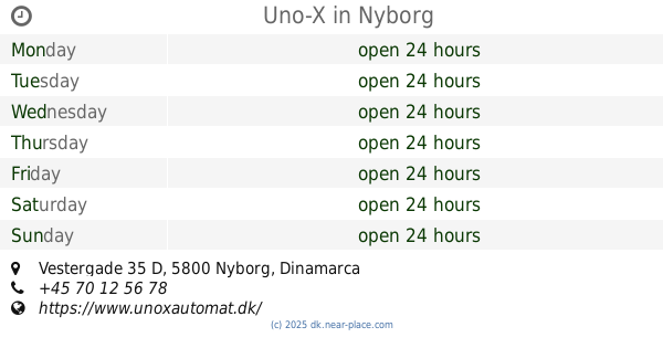
Uno-X
Vestergade 35 D, Nyborg
Gas station
read more
835 m
Go'on Nyborg
Broholm Kohavevej 1, Gudme
Gas station
read more
1.319 km
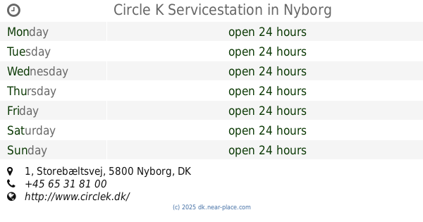
Circle K Servicestation
Storebæltsvej 1, Nyborg
Gas station
read more
1.45 km
OIL! tank & go
Storebæltsvej 5, Nyborg
Gas station
read more
1.466 km
Go'on Nyborg
Kohavevænget 1, Nyborg
Gas station
read more
1.486 km
YX
5800, Nyborg
Gas station
read more
1.627 km
OK - Tankstation
Slipshavnsvej 3, Nyborg
Gas station
read more
1.681 km
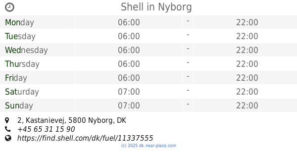
Shell
Kastanievej 2, Nyborg
Gas station
read more
3.837 km
Shell
Hjejlevej 110, Nyborg
Gas station
read more
9.143 km
OK - Tankstation
Lundsager 10, Ullerslev
Gas station
read more
9.546 km
Ullerslev
Odensevej 42, Ullerslev
Gas station
read more
9.55 km
Uno-X
Odensevej 42, Ullerslev
Gas station
read more
10.049 km
Shell
Hovedgaden 4, Ørbæk
Gas station
read more
10.28 km
OK - Gas Station
Hovedgaden 36, Ørbæk
Gas station
read more
13.982 km
Shell
Odensevej 35, Langeskov
Gas station
read more
22.241 km
1-2-3 Korsør
Tårnborgvej 31, Korsør
Gas station
read more
22.457 km
SuperBrugsen Højby
Byvænget 1, Højby
Gas station
read more
24.505 km
Shell
Nyborgvej 240-248, Vildrosevej, Odense
Gas station
read more
24.631 km
METAX station
Sivmosevænget 2,, Odense S
Gas station
read more
24.643 km
Shell Express
Sivmosevænget 2, Odense S
Gas station
read more
26.234 km
F24 Tankstation
Kochsgade 125, Odense C
Gas station
read more
26.283 km
OK - Tankstation
Kochsgade 120, Odense C
Gas station
read more
26.798 km
OK - Tankstation
Sandhusvej 19, Odense C
Gas station
read more
📑
all categories
Accounting
Administrative area level 1
Administrative area level 2
Airport
Amusement park
Aquarium
Art gallery
Atm
Bakery
Bank
Bar
Beauty salon
Bicycle store
Book store
Bowling alley
Bus station
Cafe
Campground
Car dealer
Car rental
Car repair
Car wash
Casino
Cemetery
Church
City hall
Clothing store
Colloquial area
Convenience store
Country
Courthouse
Dentist
Department store
Doctor
Electrician
Electronics store
Embassy
Finance
Fire station
Florist
Food
Funeral home
Furniture store
Gas station
General contractor
Grocery or supermarket
Gym
Hair care
Hardware store
Health
Hindu Temple
Home goods store
Hospital
Insurance agency
Jewelry store
Laundry
Lawyer
Library
Light rail station
Liquor store
Local government office
Locality
Locksmith
Lodging
Meal delivery
Meal takeaway
Mosque
Movie rental
Movie theater
Moving company
Museum
Natural feature
Neighborhood
Night club
Painter
Park
Parking
Pet store
Pharmacy
Physiotherapist
Place of worship
Plumber
Point of interest
Police
Political
Post office
Premise
Real estate agency
Restaurant
Roofing contractor
Route
Rv park, camping
School
Shoe store
Shopping mall
Spa
Stadium
Storage
Store
Subpremise
Subway station
Supermarket
Synagogue
Taxi stand
Train station
Transit station
Travel agency
University
Veterinary care
Zoo
sublocality level 1
sublocality level 2
↑