Cafe nearby Momo's Kaffebar
Coronavirus disease (COVID-19) Situation
confirmed cases
3183756
deaths
8814
Denmark
Cafe nearby Momo's Kaffebar
Momo's Kaffebar
26, Torvegade, 1400, København, DK Denmark
contacts phone
:
+45 31 37 39 50
website:
www.momo.dk
Latitude:
55.6731484
, Longitude:
12.5896222
larger map & directions
read more
nearest Cafe
24 m
Kafferiet
Wildersgade 26, København K
Cafe
read more
29 m
Cibi E Vini
Torvegade 28, København K
Cafe
read more
32 m
Emmerys
Torvegade 25, København K
Cafe
read more
150 m
Cafe Sand Wish
Sankt Annæ Gade 3B, København K
Cafe
read more
346 m
Cafe B
Prinsessegade 52, København K
Cafe
read more
446 m
Cafe Loppen
Sydområdet 4E, København K
Cafe
read more
701 m
Alice Ice Cream & Coffee
Markmandsgade 1, København S
Cafe
read more
709 m
The Corner
Strandgade 108, København
Cafe
read more
758 m
Riccos kaffebar
2.sal, Kongens Nytorv 13, København K
Cafe
read more
889 m
Cafe Ermamo
Store Strandstræde 11, København K
Cafe
read more
899 m
Cafe Fremtiden ApS
Denmark
Cafe
read more
900 m
Café Diamanten og ølhalle
Gammel Strand 50, København K
Cafe
read more
936 m
Cafe Ultimo I Tivoli v/Torben Bo Olsen
Hovedvagtsgade 8, København K
Cafe
read more
956 m
Bertel Coffee and Cake
Kompagnistræde 5, København K
Cafe
read more
978 m
Cafe Grabz
Kompagnistræde 14, København
Cafe
read more
982 m
Cafe Grabow
1201 K, Kompagnistræde 10, København
Cafe
read more
991 m
Coffee Room
Silkegade 1, København K
Cafe
read more
1.018 km
Cafe Maroc/Køkkenet
Gyldenløvesgade 4, København K
Cafe
read more
1.043 km
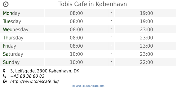
Tobis Cafe
Leifsgade 3, København S
Cafe
read more
1.044 km
Foodys Cafe
Kronprinsensgade 10, København K
Cafe
read more
1.053 km
Sonny
Rådhusstræde 5, København K
Cafe
read more
1.107 km
Depanneur Deli
Ny Østergade 25, København
Cafe
read more
1.15 km
Espresso House
Skoubogade 5-1, 1159, København
Cafe
read more
1.187 km
Hansel & Gretel Custom Cakes
Skindergade 21, København K
Cafe
read more
1.336 km
Boheme
Holmbladsgade 22, København S
Cafe
read more
📑
all categories
Accounting
Administrative area level 1
Administrative area level 2
Airport
Amusement park
Aquarium
Art gallery
Atm
Bakery
Bank
Bar
Beauty salon
Bicycle store
Book store
Bowling alley
Bus station
Cafe
Campground
Car dealer
Car rental
Car repair
Car wash
Casino
Cemetery
Church
City hall
Clothing store
Colloquial area
Convenience store
Country
Courthouse
Dentist
Department store
Doctor
Electrician
Electronics store
Embassy
Finance
Fire station
Florist
Food
Funeral home
Furniture store
Gas station
General contractor
Grocery or supermarket
Gym
Hair care
Hardware store
Health
Hindu Temple
Home goods store
Hospital
Insurance agency
Jewelry store
Laundry
Lawyer
Library
Light rail station
Liquor store
Local government office
Locality
Locksmith
Lodging
Meal delivery
Meal takeaway
Mosque
Movie rental
Movie theater
Moving company
Museum
Natural feature
Neighborhood
Night club
Painter
Park
Parking
Pet store
Pharmacy
Physiotherapist
Place of worship
Plumber
Point of interest
Police
Political
Post office
Premise
Real estate agency
Restaurant
Roofing contractor
Route
Rv park, camping
School
Shoe store
Shopping mall
Spa
Stadium
Storage
Store
Subpremise
Subway station
Supermarket
Synagogue
Taxi stand
Train station
Transit station
Travel agency
University
Veterinary care
Zoo
sublocality level 1
sublocality level 2
↑