Bar nearby Warpigs Brewpub
Coronavirus disease (COVID-19) Situation
confirmed cases
3183756
deaths
8814
Denmark
Bar nearby Warpigs Brewpub
Warpigs Brewpub
Flæsketorvet 25, København V Denmark
contacts phone
:
+45
Latitude:
55.6684002
, Longitude:
12.5601468
read more
nearest Bar
136 m
Jolene Bar
Flæsketorvet 81-85, København V
Bar
read more
242 m
Fermentoren
Halmtorvet 29C, København V
Bar
read more
283 m
Lades Kælder ApS
Kødboderne 18, København V
Bar
read more
310 m
Høker Caféen
Skelbækgade 40, København V
Bar
read more
345 m
Café Sommersted
Sønder Boulevard 39, København V
Bar
read more
406 m
Matcha Bar
Kld., Helgolandsgade 13, København V
Bar
read more
423 m
Mikkeller Bar
Viktoriagade 8C
Bar
read more
486 m
Vela Gay Club
2-4 Viktoriagade København V, København
Bar
read more
493 m
Rbabarrab Ølbar
Sønder Boulevard 53, København V
Bar
read more
510 m
City Pub
Vesterbrogade 19, København V
Bar
read more
600 m
Lounge Bar Blasé
Bernstorffsgade, København
Bar
read more
619 m
Driftselskabet Af 1. sept. 2009 ApS
Trommesalen 5, København V
Bar
read more
647 m
Biergarten Tivoli
Bernstorffsgade 7, København V
Bar
read more
693 m
The First Lady
20 c 1560 v, Kalvebod Brygge 59, 20c, København V
Bar
read more
699 m
Nimb Bar
Bernstorffsgade 5, København V
Bar
read more
703 m
NImb Vinotek
Bernstorffsgade 5, København V
Bar
read more
729 m
Scandic Copenhagen
Vester Søgade 6, København V
Bar
read more
767 m
Sommerhuset
Vesterbrogade 3, København V
Bar
read more
839 m
Cafe Larsens Plaz
Gammel Kongevej 43, København V
Bar
read more
909 m
The Shamrock Inn - Irish Craft Beer Bar
Axeltorv 7, København V
Bar
read more
912 m
Vesterbro Bryghus
2B, Vesterbrogade, København
Bar
read more
998 m
Visit carlsberg
Rådhuspladsen 3, København V
Bar
read more
1.139 km
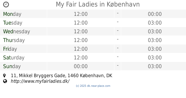
My Fair Ladies
Mikkel Bryggers Gade 11, København K
Bar
read more
1.232 km
Underbar
Vandkunsten 5, København K
Bar
read more
1.277 km
Analog Bar
Rådhusstræde 13, København K
Bar
read more
📑
all categories
Accounting
Administrative area level 1
Administrative area level 2
Airport
Amusement park
Aquarium
Art gallery
Atm
Bakery
Bank
Bar
Beauty salon
Bicycle store
Book store
Bowling alley
Bus station
Cafe
Campground
Car dealer
Car rental
Car repair
Car wash
Casino
Cemetery
Church
City hall
Clothing store
Colloquial area
Convenience store
Country
Courthouse
Dentist
Department store
Doctor
Electrician
Electronics store
Embassy
Finance
Fire station
Florist
Food
Funeral home
Furniture store
Gas station
General contractor
Grocery or supermarket
Gym
Hair care
Hardware store
Health
Hindu Temple
Home goods store
Hospital
Insurance agency
Jewelry store
Laundry
Lawyer
Library
Light rail station
Liquor store
Local government office
Locality
Locksmith
Lodging
Meal delivery
Meal takeaway
Mosque
Movie rental
Movie theater
Moving company
Museum
Natural feature
Neighborhood
Night club
Painter
Park
Parking
Pet store
Pharmacy
Physiotherapist
Place of worship
Plumber
Point of interest
Police
Political
Post office
Premise
Real estate agency
Restaurant
Roofing contractor
Route
Rv park, camping
School
Shoe store
Shopping mall
Spa
Stadium
Storage
Store
Subpremise
Subway station
Supermarket
Synagogue
Taxi stand
Train station
Transit station
Travel agency
University
Veterinary care
Zoo
sublocality level 1
sublocality level 2
↑