Bar nearby Sydvest Bodega
Coronavirus disease (COVID-19) Situation
confirmed cases
3183756
deaths
8814
Denmark
Bar nearby Sydvest Bodega
Sydvest Bodega
27, P. Knudsens Gade, 2450, København, DK Danmark
contacts phone
:
+45 52 52 02 94
Latitude:
55.6522814
, Longitude:
12.5350994
larger map & directions
read more
nearest Bar
360 m
ePizzeria
Scandiagade 76, København SV
Bar
read more
432 m
Scandic Sydhavnen
Sydhavns Plads 15, København
Bar
read more
482 m
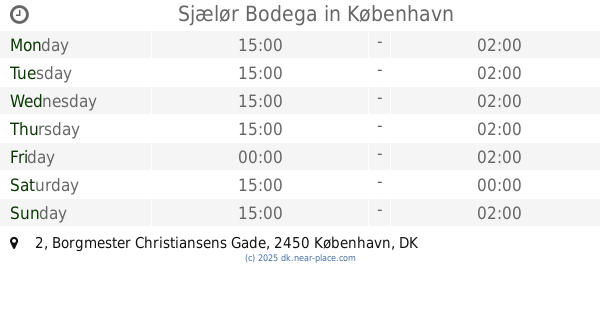
Sjælør Bodega
Borgmester Christiansens Gade 2, København SV
Bar
read more
540 m
Slusen
Frederikskaj 12, København SV
Bar
read more
583 m
Mozarts Bodega
Mozartsvej 21, København SV
Bar
read more
709 m
Café Kiki
Johan Kellers Vej 1, København SV
Bar
read more
941 m
Cafe Fremforalt
Hammelstrupvej 33, København
Bar
read more
1.367 km
Den Gylden Blonde
Vigerslev Allé 5B, Valby
Bar
read more
1.583 km
Atze Peng Bar
Enghavevej 56, København V
Bar
read more
1.587 km
Benis Bar
Enghavevej 61, København V
Bar
read more
1.921 km
Guinness Pub
Valby Langgade 43, Valby
Bar
read more
1.94 km
Rbabarrab Ølbar
Sønder Boulevard 53, København V
Bar
read more
1.964 km
Bobs Hytte
Vesterfælledvej 5, København V
Bar
read more
2.027 km
Cafe Erik
Valdemarsgade, København
Bar
read more
2.079 km
Høker Caféen
Skelbækgade 40, København V
Bar
read more
2.089 km
The First Lady
20 c 1560 v, Kalvebod Brygge 59, 20c, København V
Bar
read more
2.092 km
Bodega Det Lille Øresund
Oehlenschlægersgade 41, København V
Bar
read more
2.093 km
Café Sommersted
Sønder Boulevard 39, København V
Bar
read more
2.1 km
Kødbyens Rosébar
Kødboderne 1, København V
Bar
read more
2.11 km
Riesen Bar ApS
Oehlenschlægersgade 36, København V
Bar
read more
2.127 km
Lades Kælder ApS
Kødboderne 18, København V
Bar
read more
2.188 km
Fermentoren
Halmtorvet 29C, København V
Bar
read more
2.218 km
Restaurant MANGAL
Flæsketorvet 50, København V
Bar
read more
2.343 km
Jolene Bar
Flæsketorvet 81-85, København V
Bar
read more
2.444 km
1656
Denmark, Gasværksvej 33, København V
Bar
read more
📑
all categories
Accounting
Administrative area level 1
Administrative area level 2
Airport
Amusement park
Aquarium
Art gallery
Atm
Bakery
Bank
Bar
Beauty salon
Bicycle store
Book store
Bowling alley
Bus station
Cafe
Campground
Car dealer
Car rental
Car repair
Car wash
Casino
Cemetery
Church
City hall
Clothing store
Colloquial area
Convenience store
Country
Courthouse
Dentist
Department store
Doctor
Electrician
Electronics store
Embassy
Finance
Fire station
Florist
Food
Funeral home
Furniture store
Gas station
General contractor
Grocery or supermarket
Gym
Hair care
Hardware store
Health
Hindu Temple
Home goods store
Hospital
Insurance agency
Jewelry store
Laundry
Lawyer
Library
Light rail station
Liquor store
Local government office
Locality
Locksmith
Lodging
Meal delivery
Meal takeaway
Mosque
Movie rental
Movie theater
Moving company
Museum
Natural feature
Neighborhood
Night club
Painter
Park
Parking
Pet store
Pharmacy
Physiotherapist
Place of worship
Plumber
Point of interest
Police
Political
Post office
Premise
Real estate agency
Restaurant
Roofing contractor
Route
Rv park, camping
School
Shoe store
Shopping mall
Spa
Stadium
Storage
Store
Subpremise
Subway station
Supermarket
Synagogue
Taxi stand
Train station
Transit station
Travel agency
University
Veterinary care
Zoo
sublocality level 1
sublocality level 2
↑