Bar nearby King's Pub
Coronavirus disease (COVID-19) Situation
confirmed cases
3183756
deaths
8814
Denmark
Bar nearby King's Pub
King's Pub
Kordilgade 10, Kalundborg Dänemark
contacts phone
:
+45
Latitude:
55.6803095
, Longitude:
11.088467
read more
nearest Bar
89 m
Kontoret
Skibbrogade 44, Kalundborg
Bar
read more
250 m
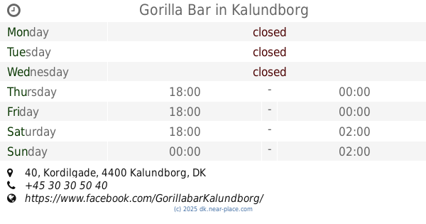
Gorilla Bar
Kordilgade 40, Kalundborg
Bar
read more
263 m
Høvlen
Skibbrogade 13, Kalundborg
Bar
read more
287 m
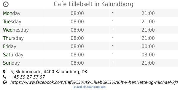
Cafe Lillebælt
Skibbrogade 5, Kalundborg
Bar
read more
293 m
Havkatten
Skibbrogade 3, Kalundborg
Bar
read more
351 m
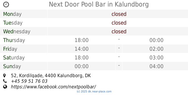
Next Door Pool Bar
Kordilgade 52, Kalundborg
Bar
read more
34.523 km
The Red Rubin
Absalonsgade 28, Slagelse
Bar
read more
34.523 km
Den Røde Rubin
Absalonsgade 28, Slagelse
Bar
read more
34.583 km
Cafe 23
Sankt Mikkelsgade 23, Slagelse
Bar
read more
35.112 km
Cozy Loungebar
Skovsøgade 1A, Slagelse
Bar
read more
51.991 km
Købmanden - SMØRREBRØD
Rønnedevej 13, Ringsted
Bar
read more
53.167 km
Pool Caféen
Skibhusvej 83, Odense C
Bar
read more
53.253 km
Østens grill Nansensgade
Nansensgade 2, Odense C
Bar
read more
53.705 km
Andersens Bodega
Georgsgade 1, Odense C
Bar
read more
53.829 km
Blomsten og Bien
Overgade 45, Odense C
Bar
read more
54.028 km
VUC Fredagsbar
Kottesgade 6, Odense
Bar
read more
54.267 km
Dunkbar
Jernbanegade 24A, Odense C
Bar
read more
54.494 km
Old Irish Pub
Vintapperstræde 4, Odense C
Bar
read more
54.56 km
Mose Boden - Burger, Hotdog, Toast, Pita og Durum
Munke Mose Allé 94, Odense C
Bar
read more
54.628 km
The Australian Bar
Brandts Passage 10, Odense C
Bar
read more
54.907 km
Dania Trading Odense ApS
Vesterbro 26, Odense C
Bar
read more
54.999 km
Billarden 93 ApS
Vesterbro 60, Odense C
Bar
read more
55.904 km
Center Pub Tarup Center
Odense
Bar
read more
56.716 km
Lunds Bodega
Middelfartvej 155, Odense V
Bar
read more
65.439 km
Konrad Næstved
Ramsherred 5, Næstved
Bar
read more
📑
all categories
Accounting
Administrative area level 1
Administrative area level 2
Airport
Amusement park
Aquarium
Art gallery
Atm
Bakery
Bank
Bar
Beauty salon
Bicycle store
Book store
Bowling alley
Bus station
Cafe
Campground
Car dealer
Car rental
Car repair
Car wash
Casino
Cemetery
Church
City hall
Clothing store
Colloquial area
Convenience store
Country
Courthouse
Dentist
Department store
Doctor
Electrician
Electronics store
Embassy
Finance
Fire station
Florist
Food
Funeral home
Furniture store
Gas station
General contractor
Grocery or supermarket
Gym
Hair care
Hardware store
Health
Hindu Temple
Home goods store
Hospital
Insurance agency
Jewelry store
Laundry
Lawyer
Library
Light rail station
Liquor store
Local government office
Locality
Locksmith
Lodging
Meal delivery
Meal takeaway
Mosque
Movie rental
Movie theater
Moving company
Museum
Natural feature
Neighborhood
Night club
Painter
Park
Parking
Pet store
Pharmacy
Physiotherapist
Place of worship
Plumber
Point of interest
Police
Political
Post office
Premise
Real estate agency
Restaurant
Roofing contractor
Route
Rv park, camping
School
Shoe store
Shopping mall
Spa
Stadium
Storage
Store
Subpremise
Subway station
Supermarket
Synagogue
Taxi stand
Train station
Transit station
Travel agency
University
Veterinary care
Zoo
sublocality level 1
sublocality level 2
↑